|
|
| 1. INTRODUCTION |
|
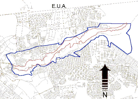
The Instituto Municipal de Planeación (IMPlan), Tijuana, Baja California, has among its current projects the rehabilitation of Arroyo Alamar, a tributary of the Tijuana river. The main objective of the project is to rehabilitate the Arroyo Alamar and its flood plain to encourage planned land use and preserve primary hydroecological functions. The project will satisfy a host of urban-planning needs, including the preservation of riparian areas, flood management, planned land use, recreation, landscaping, a green corridor, replenishment of groundwater, improvement of water quality, and compliance with federal stream zoning regulations. The project encompasses the 10-km reach of Arroyo Alamar, located between the bridge on the toll road to Tecate to the east, and the channelized reach near the confluence with the Tijuana river to the west (Fig. 1).
|
|
| To perform the hydrological and hydroecological design of the rehabilitated channel includes the determination of flood discharges for selected design frequencies, and the calculation of water-surface profiles. The U.S. Army Corps of Engineers HEC-RAS (Hydraulic Engineering Center - River Analysis System) model was used to calculate the water-surface profiles. |
| 2. DESIGN FLOOD DISCHARGES |
|
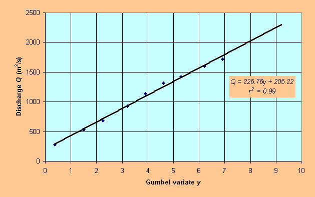
A hydrological study to determine design flood discharges for 2 to 1000-yr frequencies has been performed by Ponce (2000). Herein, the Gumbel method was used to calculate the 5000-yr and 10000-yr flood discharges, based on the previous findings. Fig. 2 shows the Gumbel fitting and Table 1 shows the estimated discharges.
|
|
|
Table 1. Estimated discharges
using Gumbel method.
|
| Return period (yr) |
Gumbel variate y |
Flood discharge Q (m3/s) |
| 5000 | 8.52 | 2140 |
| 10000 | 9.21 | 2290 |
| 3. HEC-RAS MODELING |
|
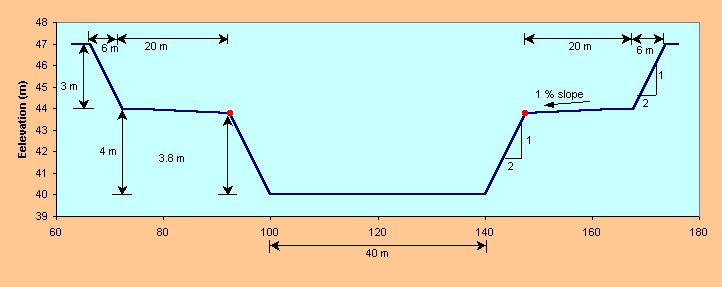
The HEC-RAS model calculates the water-surface profile of a channel system, when presented with appropriate upstream and downstream boundary conditions. 3.1 Length and elevation data The Alamar Project has established a tentative project alignment with a total channel length of 9880.849 m. The upstream point, with invert elevation 80 m, is at the bridge on the toll road to Tecate. The downstream point, with invert elevation 40 m, is at the confluence with the channelized reach near the confluence with the Tijuana river. This provides an average channel slope of 0.004048. 3.2 River-system schematic The river-system schematic is developed by drawing and connecting the various reaches of the system within the geometric data editor. The project reach, of length 9880.849 m, was subdivided into reaches at an equidistance of 20 m, for a total of 494 reaches and 495 cross sections. The small reach interval (20 m) was adopted to ensure the accuracy of the water-surface profile computation. River stations are numbered from 001 to 495. 3.3 Cross-section geometry A prismatic channel of a chosen cross-sectional geometry was adopted for design. The channel consists of a main channel and left and right overbank channels (flood plains). The bottom width of the main channel is 40 m, and the main channel depth is 3.8 m. The side slopes of the main channel are 2 horizontal to 1 vertical. The overbank channels are 20 m wide each, with channel depth 3.0 m. and side slopes 2 H:1 V. The overbank channels drain into the main channel with a 1% transversal slope. Figure 3 shows the channel design. |
|
|
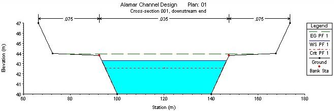
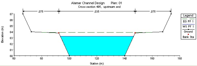
In HEC-RAS, cross-sectional data is entered from left to right, looking in the downstream direction.
The left channel bottom x-coordinate was specified as 100 m, and the corresponding cross-sectional coordinates
were calculated using a spreadsheet. The x-coordinate left overbank limit is 92.4 m, and the x-coordinate right overbank limit is
147.6 m.
Figure 4 shows typical cross sections generated by HEC-RAS for the discharge of 550 m3/sec, at cross section 001 (downstream end) and cross section 495 (upstream end). |
|
|
3.4 Energy loss coefficients Several types of loss coefficients are utilized by HEC-RAS to evaluate energy losses. These are the Manning's n for friction (boundary) loss, contraction and expansion coefficients to evaluate transition loss, and bridge and culvert loss coefficients. At the present level of approximation, all secondary energy-loss coefficients have been neglected. Appropriate values of Manning's n are significant to the accuracy of the calculated water surface profiles. The Manning's n value depends on a number of factors, including surface roughness, amount and type of vegetation, channel irregularities, channel alignment, scour and deposition, presence of obstructions, size and shape of channel, stage and discharge, seasonal changes, temperature, and bed material load. Manning's n values for inbank channel flow was estimated at 0.035, and for overbank flow at 0.075. These values are consistent with established practice. The values of Manning's n recommended by HEC-RAS are shown in Table 2. 3.5 Boundary conditions The boundary condition is necessary to establish the starting water-surface elevation at either end of the channel system. Since the flow is subcritical, the boundary condition is specified at the downstream end of the channel system. The average channel slope So= 0.004048 has been specified as downstream boundary condition in the present study. 3.6 Flood discharge Flood discharge information is required at each cross section in order to compute the water-surface profile. The flow value is entered at the upstream end of the reach, and it assumes that the flow remains constant until another flow value is encountered with the same reach. The flood discharges corresponding to 10-, 50-, 100-, 500-, 1000-, 5000- and 10000-yr return periods were used to calculate water-surface profiles with HEC-RAS. In addition, the flood discharge of 550 m3/sec was also considered at IMPlan's request.
|
| 4. RESULTS |
|
The HEC-RAS model results are shown in Table 2. Flow depths vary from 3.278 m to 6.779 m; inbank flow velocities vary from 3.6 to 6.04 m/s; overbank flow velocities vary from 0.77 to 1.56 m/s. The Froude numbers vary from 0.68 to 0.77. For the 1000-yr design flood discharge, the freeboard is 1.117 m.
|
|
Table 2. HEC-RAS results
showing flow depths, mean velocities, Froude numbers, and freeboard for corresponding return periods.
|
| Return period (yr) |
Discharge (m3/s) |
Flow depth (m) | Inbank flow mean velocity (m/s) | Overbank flow mean velocity (m/s) | Froude number | Freeboard (m) |
| - | 550 | 3.278 | 3.60 | - | 0.68 | 0.522 |
| 10 | 680 | 3.706 | 3.87 | - | 0.69 | 0.094 |
| 50 | 1140 | 4.810 | 4.70 | 0.77 | 0.72 | 2.190 |
| 100 | 1310 | 5.147 | 4.62 | 1.18 | 0.73 | 1.873 |
| 500 | 1600 | 5.677 | 5.31 | 1.17 | 0.75 | 1.323 |
| 1000 | 1720 | 5.883 | 5.45 | 1.25 | 0.75 | 1.117 |
| 5000 | 2140 | 6.554 | 5.90 | 1.49 | 0.77 | 0.450 |
| 10000 | 2290 | 6.779 | 6.04 | 1.56 | 0.77 | 0.221 |
| 5. SUMMARY |
|
A hydrological design has been accomplished for the Arroyo Alamar rehabilitation project, Tijuana, Baja California. The design used the U.S. Army Corps of Engineers' HEC-RAS model to determine flow depths, mean velocities, Froude numbers, and freeboards for a typical cross-section featuring a compound prismatic channel with left and right overbank side channels (Fig. 3). The flow depths and mean velocities obtained from the model, shown in Table 2, are consistent with established practice. |
| http://ponce.sdsu.edu/protected21/alamarhydrologicaldesign.html | 040417 |