|
|
|
| 1. Introduction |
|
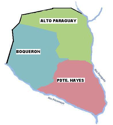
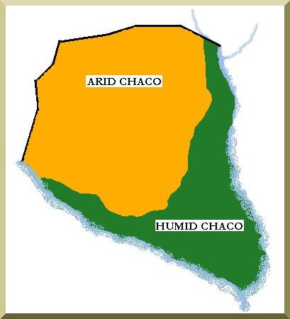
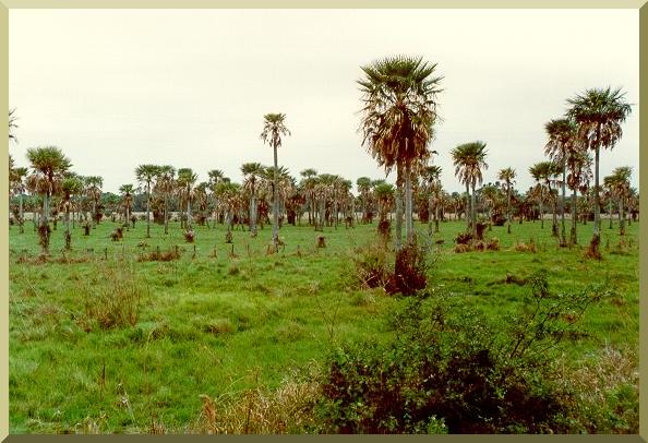
The word Chaco originates from the Quichua word "chacú," which means "place of hunting." The Chaco was a well known place by the Incas; they would migrate for a few months each year to the Chaco to hunt and to give renditions to their gods. Later, during the colonial period, this region was hardly noticed and there was no land exploitation. Today, 80% of the economy is sustained by cattle ranching and another 10% by agriculture. This remote land in South America, whose limits remain controversial, includes parts of Argentina, Bolivia, Brazil and Paraguay. The Chaco has an area of about 1,500,000 km². It is divided into two clearly identifiable ecoregions: the humid Chaco and the semiarid or dry Chaco (Fig. 1). The climate is extreme, ranging from -7oC to 48oC. Both of these ecoregions are clearly distinguishable in the Paraguayan Chaco. The western portion of Paraguay, limited to the east by the Paraguay River, also known as the Paraguayan Chaco or Chaco Boreal, has approximately 246,925 km², which represents 25% of the South American Chaco and 60% of Paraguay. The population density is 0.04 inhabitants per square kilometer, and it is home to only 2.5% of the Paraguayan population. Three departments, Alto Paraguay, Boquerón and Presidente Hayes, compose the Paraguayan Chaco. Of these three, Boquerón is the only one that has not shown a clear increase in population in the past 10 years; it is also the department with the largest indigenous population. The Chaco has a general gradient sloping east; it is a great alluvial plain, which has been formed with aeolian, fluvial and marine deposits providing deep soils, free of rocks. Summer rains are generally concentrated in the southern zone. Floods are common in this region, which is characterized by its palm trees and sugarcane fields, and where it rains approximately 1300 to 1500 mm per year. In the southern Chaco, the flat wetlands provide a habitat for wet vegetation, such as marshes and tall weeds. In the northern Chaco, the tectonic faults and the arid climate provide a habitat for savannas. Near the Bolivian border, a very undulated topography is found, with sand dunes of low elevation; this could be considered the start of the Andes mountain range. Near the Bolivian border, the Cerro León chain has elevations of about 125 m. The northern region has an average of 500 mm of rain per year. Northern soils have been barely used, mainly because of the long distance to commercial markets, its arid characteristics and the general lack of knowledge about the region. The Paraguayan Chaco comprises an area larger than the state of Oregon, Great Britain and eight Latin American countries. Nonetheless, it is still hardly populated, and studies for sustainable development of the land have yet to be accomplished. Although the Paraguayan Chaco is wholly contained within the Paraguay River basin, it is necessary to analyze other hydrologic aspects to understand the region's peculiarities. Mainly, the two most important rivers are: (1) the Paraguay, which contains several slow meandering tributaries along the way; and (2) the Pilcomayo, which feeds Estero Patiño, one of the better preserved wetlands in the Chaco. Downstream of the wetlands, the Pilcomayo drains into the Paraguay River close to the city of Asunción. Continuing downstream, the Paraguay River eventually joins the Paraná, to finally end at the Río de La Plata basin, and into the Atlantic Ocean. In a hydrologic sense, the Paraguayan Chaco is conditioned by three elements: local precipitation, the hydraulics of the Pilcomayo River, and the Paraguay River and its tributaries (Fig. 1). |
|
|
| 2. Paraguay River |
|
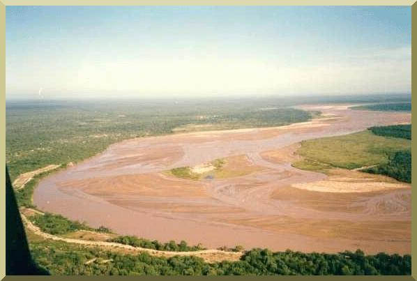
The Paraguay river originates upstream of the city of Cáceres, Brazil, north of the Brazilian Pantanal of Mato Grosso. The basin has approximately 1,000,000 km² from its headwaters to the southwest corner of Paraguay, where it drains into the Paraná river. The average discharge is 2500-3500 m³/s with the maximum being 7000 m³/s. Records indicate a low saline concentration, a pH of 7, alkalinity of 25 mg/L, hardness of 26 mg/L and suspended solids of 12 mg/L. As the river heads towards the Paraná the salinity increases. All the water that drains from the Brazilian Pantanal ends up in the Paraguay River and the Paraguayan Pantanal. The widest portion of the basin is at Corumbá, with approximately 300 km. When the river reaches Porto Esperança, south of Corumbá, it makes an abrupt turn heading southwest as it enters the Paraguayan Chaco (Fig. 3). Once the river is in the Chaco territory, it regains its natural direction (north-south). From there, the Paraguayan Pantanal extends on both sides until it reaches the Apa River (Fig. 4). The same vegetation as in the Brazilian Pantanal can be seen along the Paraguay River for 250 km with varying width, from 40 to 10 km (Fig. 5). The flood plain occupies an area of 400,000 ha, which in times of high floods can reach about 600,000 ha. This area has the highest medium temperature of the Chaco, about 25 oC year round and an average rainfall of 1100 mm. Upstream, where the Chaco and the Brazilian Pantanal meet in Bahía Negra, the channel velocities are very slow; therefore, when high floods occur, they take three or more months to reach the southern Chaco. The southern Chaco receives Pantanal floodwaters in the months of October and November. The waters of the Paraguay River in the southern Chaco from the Apa river to its end in Asunción have higher velocities; therefore, sand beaches, sand banks and islands on the margin start to appear, as well as river lagoons. There are numerous tributaries of the Paraguay River extending from south of the Pilcomayo River to the northern Chaco Pantanal. All of these watersheds are within the territory of the southern Chaco. Most of the Paraguay River tributaries are not navigable, but are important because of the irrigation water they provide. Among the most important are: the Pilcomayo, Negro, Siete Puntas, Confuso, Verde, Montelindo and Aguaray-Guazú on the right margin; and the Apa, Aquidaban, Ypané, Jejuí and Tebicuary (which are located on the eastern region of Paraguay) on the left margin. The flows and reaches of the rivers are shown in Table 1.
|
|
|
|
The central Chaco's drainage is made of paleochannels and intermittent gorges which are dry most of the year, and transport overflows in the rainy months of the summer to the southern tributaries of the Paraguay River. The region has an average slope of 0.0003, draining towards the east. Upstream, on the Paraguay River, there is a complex drainage web made of the Yacaré, Pacú, San Juan, Mosquito and Negro rivers. All of these are perennial, but have a very short length and are mainly dependent on the water levels of the Paraguay River. During the summer months, which coincides with low water levels in the Paraguay River and with rain in the surrounding areas, the rivers flow eastward and drain into the Paraguay River. In the months of high water levels (May through August), the backwater reaches 50 to 80 km westward. |
| 3. Pilcomayo River |
|
The Pilcomayo river originates at 4000 m above sea level in the Bolivian andes, north of the city of Potosí. After flowing for about 500 km in the Bolivian valleys, plateaus and canyons, it enters the South American Chaco through the city of Villamontes, where the gradient is reduced from 0.045 to 0.033. The upper basin, located in the Andes, has a surface area of about 80,000 km², while the lower basin, properly in the Chaco region, has an area of about 180,000 km². From Ybybobo in Bolivia, the river wanders through strong meanders; in the rainy season the flow increases and so does the velocity. Substantial erosion is seen in its concave banks, due to the meandering action. Once at the Horqueta Port (42 km SW of General Díaz), the river starts to digress, transforming itself from a clearly defined channel into a series of wetlands and marshes, such as the Patiño and Tinfunke marshes. The water feeds some temporary basins, infiltrates the soil, or evaporates. At Salto Palmar, the river regains its original course and direction, with a smaller flow and sediment load, but more salinity. This last extension of the river runs for 240 km as it drains into the Paraguay river south of the city of Asunción. The Pilcomayo is the longest tributary of the Paraguay River in the Chaco. The rivers Confuso (Fig. 6), Negro, Aguaray-Guazú, Verde, Siete Puntas and Montelindo compose the Pilcomayo delta. Of these, the first three receive an important amount of overflow from the Pilcomayo, plus draining the water of their respective watersheds. The salt level in the water increases from the Confuso upward, as the rivers part from the Pilcomayo to the south, which carries sweet water. Another peculiarity of the Pilcomayo is that along its course in the Paraguayan Chaco, it does not receive water from a single tributary (Fig. 7). The hydrologic system of the Pilcomayo River in the Chaco consists of the following components: (1) The Upper Pilcomayo, which encounters its hindrance 70 km south of the Paraguay-Bolivia border; (2) gorges that are formed at that point and transport the water to (3) the marshes of Tinfunké and Patiño; (4) the rivers Montelindo, He-é, Siete Puntas, Verde, Confuso and lower Pilcomayo, which are born out of the marshes and finally drain into the (5) Paraguay river. |
|
|
|
The two characteristics that stand out the most in the hydrologic and fluvial phase of the Pilcomayo are: (1) the extreme variability in flow discharge, ranging from 3 to 3000 m³/s, in the periods of drought and floods, respectively. Secondly, there is the pronounced erosion process that occurs in the upper basin, with an average sediment load of 98 million tons per year. The Pilcomayo deposits about 50,000 m³ of sediments per year, with water densities ranging from 50 to 100 kg/m³ (Fig. 9). The cause of this phenomenon is due to the fact that in the upper basin of the Pilcomayo meanders through the Andes, where outcrops of erosional rocks and an intense rainfall regime during the summer months produce great quantities of sediment. Records dating back to 1944 show the retreat of the Pilcomayo, due to sediment deposition in the downstream marshes. To this date, the river has lost 300 km in length, and the end of its main channel is now located only 70 km from the Bolivia-Paraguay border. The Patiño marsh, which is located 250 km south of this point, is receiving a small amount of flow, harming the local fauna and flora. In an attempt to lessen the effects of this retreat, the governments of Paraguay and Argentina have undertaken since 1991 a series of actions to slow this natural phenomenon. These actions led to an irregular distribution of channels along the sides of the Pilcomayo. From 1991 through 1994, most of the low and medium flows were diverted to Argentina. From 1995 to 1996, these levels were diverted to Paraguayan territory. Since 1997, this flows have again been diverted into Argentinian territory. Another important characteristic of these rivers is that their basins are not unequiivocally defined, due to the relatively uniform morphology of the terrain. This phenomenon causes a transversal action in the watersheds, increasing them or changing them, in many cases due to anthropogenic actions (i.e., construction of channels, roads, dams, etc.). Therefore, the effects of the increase of water level in the Pilcomayo are variable and unpredictable. Under normal conditions, the flow is transported to the lower Pilcomayo and the Montelindo rivers; under extreme conditions, flows can reach as far as the Verde river. The extreme variability of flows is attributed to the lack of control in the upper basin. Currently, the high waters are diverted to the Argentinian side of the Chaco and substantial harm is being done to downstream marshes, which sustain a very delicate and intricate ecosystem. The marshes of Patiño and Tinfunké are of great importance, not only to the rivers that are born there but also because they constitute a very important feeding point for the fisheries. Upstream of the marshes, the penetration of sunlight decreases due to the heavy concentration of solids, such that microorganisms that sustain fishes are not able to proliferate. The Pilcomayo presents two distinct hydrologic moments: (1) the period of low flows, extending from May to October of each year, which coincides with winter and small rain; during these periods, flows are as low as 3 to 10 m³/s; (2) the period of high flows, during the summer, when high flows are of the order of 1000 to 3000 m³/s; these high flows give rise to the wetlands and the excess flows that the smaller rivers receive. There is no set cross-sectional area for the channel bottom, because the bed is always moving; this, added to the fact that the overflow is irregular during floods, makes it hard to develop a trustworthy hydrometric analysis. Therefore, the Pilcomayo basin is one in which all the parameters are presented in an extreme fashion, constituting a challenge to modern technology. Such challenges encompass the analysis and comprehension of the phenomenon, the design and execution of human interventions, as well as a search for a new institutional and political framework based on the river's international importance. |
| 4. Arid Chaco |
|
In this natural region of 113,400 km², the terrain is dry, with thorny bushes being its main feature. It has an ondulating characteristic, an indication of the earlier rivers that used to flow through the region. The flora and fauna seem to have reached equilibrium, but the biological aspects are still dependent on the hydrologic cycle. With small exceptions, there is no water available for 180 days each year. Periods of humidity do not last longer than 90 days straight; 80% of the rain comes in the summer months, producing a monsoon-like environment. The sandy texture and the dryness make soils very porous and permeable. Nonetheless, the type of monsoonic rains that occur during the summer saturate the soils too fast for the entirety of the water to be absorbed; therefore, ending as runoff into an ephemeral river. As a general rule, in the central region of the Chaco there is a drought every 7th year, with rains of 600 mm/year. As one moves to the north, the annual average reduces to about 400-500 mm and the evapotranspiration is of the order of 2000 mm per year. In the north, subterranean waters are the main source of supply and travel in a southeastern direction. These waters are formed through a complex process of infiltration that begins as the waters are washed in the saline deposits of the Andean mountain range. If sweet waters, especially from the Pilcomayo floods, did not superpose these aquifers, there would be a risk of generalized salinization that could later lead to desertification. On the northwest, there are fresh-water artesian aquifers (20 to 30 m) along the Pilcomayo and near the Bolivian border. Moving towards the center and the east, the soils become less sandy and it is thought that due to a geologic fault, the grade changes and the aquifers are at greater depth (100-200 m). Aquifers become very saline and rich in minerals (5000 mg/L), rendering them useless for irrigation purposes. The most important river in the area is the Timane (located near Pablo Lagerenza), which is said to be very curious because it lacks a beginning or an end. In fact, during times of high flows, almost all the water accumulates in lakes; the two most important lakes being Palmar de las Islas and Trinidad. It is an intermittent fresh-water channel with an average flow of 134 m³/s. The basin receives an average of 600 mm per year of rainfall; the drainage area is 56,350 km² and the evapotranspiration is 718 mm. The Timane receives flood waters from the Parapití and the Yzozog river of Bolivia, producing high floods without any precipitation. Of the northern lakes, few studies have been done about the capacity, storage and quality, and most are drying out and are only of geographic use. The area around Pablo Lagerenza (Northern Chaco) receives 500 mm of rain per year, while in Fortin Ravelo (Bolivia), about 50 km from Lagerenza, the rainfall amount is 1064 mm per year. This shows the extreme variability of water supply in the northern Chaco and its surrounding areas.
|
| 5. Humid Chaco |
| Though the South American Chaco is noted by its dryness and
arid conditions, in the southern Paraguayan Chaco, there exists a
system of wetlands originating from three hydrologic elements:
(1) the overflow waters from the Paraguay river, (2) floods from
the Pilcomayo river, and (3) rainfall activity in this area. The
soils are of clayey texture, inhibiting infiltration; therefore,
during the months of heavy rain most of the area is flooded. On
the average, the region is flooded four months out of the year, cutting
road communication in some areas (Fig.
10). In the transition zone between the arid and the humid
Chaco, the topography is a little more elevated, causing high
runoffs and lesser floods.
The floods occur in the months of summer, where the stage on the Paraguay is low; during winter, when there are high stages on the Paraguay, the water is diverted inwards in some cases, but not to the extent to cause floods. Inland-diverted waters in the south can reach from 80 to 150 km upstream. The aquifers in the southern region are even more saline, sometimes so much that they cannot be used as drinking water. Nonetheless, the fields get enough rain water, 1300 to 1500 mm per year, so the cattle raising industry does not suffer from this condition. The rains that cause floods during the summer months are not drained by adequate mechanisms; therefore, most of the water is not used in an efficient way. This lack of potable water and the resources to drain them efficiently, causes some problems. Water harvesting by building large water tanks of clay or by collecting rainwater from the roofs is the main way to collect potable water. |
|
|
|
In the Chaco, the wetlands are extended horizontally, and depth
can range from a few centimeters to 1 or 2 m, with emerging
vegetation. Wetlands can further be divided into two types: (1)
marshes, which have water permanently, and (2) washes that contain
water momentarily due to floods or rain. |
| http://ponce.sdsu.edu/chaco_hydrology.html
|
020916
|