|
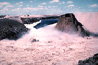
Fig. 1 Failure of Teton Dam, Idaho, June 5, 1975.
DOCUMENTED CASES OF EARTH DAM BREACHES
[Original print version 1982; this revised online version 2020]
Victor M. Ponce and Shurui Jiang
[201230]
A. INTRODUCTION
The failure of earth dams has become a subject of increasing concern among dam engineers, federal and state officials and the public at large. There are approximately 50,000 earth dams in the U.S., and probably about five times that number throughout the world. However, very little is know of the actual failure mechanisms, or of remedial measures before and during a failure event.
Earth dam failures can have many diverse causes. However, most failures that have been documented have been attributed to insufficient spillway capacity leading to overtoppigng (hydrologic cause), or piping and uncontrolled erosion of some portion of the embankment (geotechnical cause). In any of these cases, the failure usually results in the eventual development of a breach comprising a certain length of the embankment.
The breach morphology is a subject that has received very little attention. Its relevance is manifest when studies of hypothetical breaches are undertaken to aid in planning emergency preparedness. The shape and time evolution of the breach, along with size of dam and reservoir, determine to a large extent the characteristics of the outflow hydrograph during a postulated earth dam breach.
Breach widths have been documented in a large number of cases, although predictive correlations are almost nonexistent. In most cases, it appears that the breach geometry conforms itself such that Yo < Wb < 3Yo, in which Wb = breach width, and Yo = dam depth, while side slopes tend to vary as a function of the soil type (Johnson and Illes, 1976).
The mechanics of breach formation determine to a large extent the time evolution of the breach geometry. The classical hypothesis of instantaneous failure is obviously out of place in the case of earthen dams where the breach develops by a gradual washout of the embankment. Data on failure times is scant, again depending on breach size and reservoir storage. Documented failure times show that the failure event is anything but instantaneous, lasting from 3 to 12 hours. In certain cases of nonengineered embankments with mild side slopes, the failure may even last 24 to 48 hours and still not comprise the total depth of the embankment (Ponce and Tsivoglou, 1981).
The objective of this report is to present, in a concise manner, the available information on breach failures and related hydrologic data. This compendium will be used as supporting documentation for future studies of breach dynamics and morphology.
Approach
The approach utilized is to comb the available literature for references to earth dam failures involving breach occurrences. A brief narrative taken from the original sources is followed by a preliminary analysis of certain hydraulic parameters relevant to the breach morphology. These are Qp = peak discharge; Yo = (maximum) depth of dam; Wd = (top) width of dam; Db = (average) depth of breach; Wb = (top) width of breach. Some of these values were not given in the original source, and have been estimated using the best judgment available.
In addition to these values, other hydrologic and hydraulic values are noted for reference and further analysis. These are the reservoir capacity, drainage area above dam, storage at time of failure, duration of failure, and the Froude number based on peak discharge:
|
Qp F = _________________ Wb ( g Db3 )1/2 | (1) |
and a shape factor S, defined as follows:
|
Wb Db S = _________ Wd Yo | (2) |
Studies had seemed to indicate that such a shape factor may be applicable to breaches of earth dams (U.S. Army Engineer Waterways Experiment Station, 1961).
Analysis
Pending more detailed studies into the phenomenologic description of breach
morphology, an analysis is made here of the correlation between the Froude
number based on peak discharge and the shape factor S, based on all
available data. Such a plot is shown in
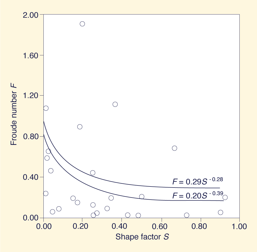
|
Fig. 2 Relationship between Froude number F and shape factor S.
An equation encompassing the upper limit of the data is given as follows:
| F = 0.20 S -0.39 | (3) |
which can be compared to:
| F = 0.29 S -0.28 | (4) |
which is the equation given in Reference (3).
A physical reasoning for the form of Eqs. 3 and 4 is apparent when the main hydraulic features of the breach flow are recognized. If the breach cross section is small, the control is located upstream, and the Froude number trends to rise accordingly, approaching critical flow. Conversely, if the breach is large, bottom friction along the channel prevails and control is located downstream, leading to a small (subcritical) Froude number. This reasoning emphasizes the interrelationships between the local hydraulics and the breach geometry, in that one conditions the other much like a feedback-type mechanism.
Concluding remarks
The available information on earth dam failures and breach geometry has been catalogued and documented for use in future studies. Preliminary analysis of the data shows some promise in determining a breach geometry descriptor based on breach hydraulics and related morphology. Further study and analysis is forthcoming.
Section B of this report contains an event-by-event description of documented breaches, with all relevant data noted. Section C is a list of references consulted in the course of this study.
B. DOCUMENTED CASES
|
Mode of failure: Overtopping.
Description: A cloudburst on May 29, 1902 caused the dam to overtop, creating a breach of approximately 100 ft.
Hydraulic properties:
Qmax = 325 cfs (estimated)
Wb = 80 ft
Db = 23 ft (estimated)
Wd = 207 ft
Yo = 23 ft
F = 0.0052
S = 0.483
Reservoir capacity = 40 ac-ft
Drainage area above dam: No data available
Storage at time of failure: No data available
Duration of failure: 3 hours (estimated)
Year built: 1887
Date failed: May 29, 1902.
Reference: Babb, A O., and T. W. Mermel. 1968.
"Catalogue of dam disasters, failures, and accidents,"
PB 179 243, U.S. Bureau of Reclamation, Washington, D.C., 89 p.
|
|
Mode of failure: Leakage, burrowing animals.
Description: A flood of unprecedented magnitude caused the second failure of Lake Avalon Dam in 12 years. Failure was caused by water forcing a passage through the dam, not by flowing over the top.
There are two opinions as to what caused the failure. One is that
animals burrowed into the downstream side of the dam causing the
earth facing to weaken. The other is that leakage at the right
end of the dam caused the failure. Efforts were attempted to stop this leakage
by sheet piling, but without complete success.
Whether the failure was due to animals burrowing in the earth
face and weakening it or to faulty connection of the dam with
the right bank could not be ascertained, as the failure occurred during the night.
Hydraulic properties:
Qmax = 82,000 cfs
Wb = 450 ft
Db = 45 ft (estimated)
Wd = 1,380 ft
Yo = 48 ft
F = 0.097
S = 0.327
Reservoir capacity = 6,300 ac-ft
Drainage area above dam: No data available
Storage at time of failure: No data available
Duration of failure: 2 hours (estimated)
Year built: 1894
Date failed: Oct. 1, 1904.
References:
Murphy, E. C. 1905. "Failures of Lake Avalon Dam near Carlsbad, N. M.,"
Engineering News Record, Vol. 54, No. 4, July 6, 1905, 9-10.
Middlebrooks, T. A. 1953.
"Earth dam practice in the United States," Centennial Transactions, ASCE,
Vol. Ct, Paper No. 2620, 697-722.
|
|
Mode of failure: Overtopping.
Description: A severe rainstorm caused the
overtopping of Sherburne Dam. About one-half of it was washed
out and about one-third of the lower side of the remaining
portion was also carried away for its entire length.
Hydraulic properties:
Qmax = 500 cfs (estimated)
Wb = 150 ft
Db = 34 ft (estimated)
Wd = 300 ft
Yo = 34 ft
F = 0.203
S = 0.5
Reservoir capacity = 61 ac-ft
Drainage area above dam: No data available
Storage at time of failure: No data available
Duration of failure: 3 hours (estimated)
Year built: 1883
Date failed: September 3, 1905.
Reference: Musson, E. F. 1905. "Failure of two reservoir dams by flood
at Sherburne, |
|
Mode of failure: Overtopping.
Description:
The failure of Dells Dam came after a prolonged effort by a large
force of men trying to keep the crest of the dike above the water level.
The rise in the water level was due to an unusually heavy precipitation,
the heaviest since the completion of the dam. When the large force of
workmen was called to abandon its efforts, the water level had risen
8 ft above the crest of the spillway. Within 40 minutes after the
water had broken over the dam, earthwork was carried away and its
concrete corewall overturned, leaving a gap of 400 ft.
Although no evidence shows inadequate construction of the dam,
definite information is lacking as to where the designers based
their calculations for the spillway. Equally difficult is
finding the person responsible for this design, for there
appears to have been a lack of a responsible head or a faulty division of responsibility.
Also noteworthy are the characteristics of Black River itself.
This river is known among hydrologists as a "flashy" stream.
The geology of Black River consists of rocks and banks abruptly rising 40 to 60 ft, covered with glacial deposits. The watershed is about 950 square miles with an average width of only 20 miles.
Hydraulic properties:
Qmax = 191,940 cfs (estimated)
Wb = 370 ft
Db = 59 ft
Wd = 960 ft
Yo = 59 ft
F = 0.202
S = 0.925
Reservoir capacity = 10,580 ac-ft
Drainage area above dam: 950 sq. mi
Storage at time of failure: No data available
Duration of failure: 40 min (estimated)
Year built: 1910
Date failed: October 6, 1911.
Reference:
Pence, W. D. 1911. "Failure of the Dells and Hatfield dams and the devastation of Black River Falls,
Wis., Oct. 6, 1911," Engineering News Record, Vol. 66, No. 16, Oct. 12, 482-489.
|
|
Mode of failure: Overtopping.
Description: Heavy rains brought the failure through
overtopping of Dells Dam, 6 miles upstream of Hatfeld Dam. The flood wave
caused by the breaching of Dells Dam destroyed Hatfield dam. When the
rush of water reached Hatfield dam, water rose over the wingwall and
quickly stripped away the earthwork over the corewall. The wingwall, at
the west end of the dam, was 2 ft lower
than that at the east end of the spillway, thus accounting for the overflow outside
the limits of the spillway. Breaching along the east dike occurred moments
later. Action taken before the failure of Dells Dam enabled workers to
cut into the bank of the canal leading to the power station. This action
saved both the canal and power station from destruction.
According to somewhat rapid examinations made in the progress
of field inspections, no evidence was found of faulty construction.
However, it does not appear that the designers gave adequate
consideration to the characteristics of Black River,
in providing spillway relief to flood waters at maximum discharge.
Hydraulic properties:
Qmax = 120,000 cfs (estimated)
Wb = 22 ft (estimated)
Db = 300 ft
Wd = 450 ft
Yo = 22 ft
F = 0.683
S = 0.667
Reservoir capacity = 9,923 ac-ft
Drainage area above dam: 1,350 sq. mi
Storage at time of failure: No data available
Duration of failure: 2 hours (estimated)
Year built: 1908
Date failed: October 6, 1911.
Reference:
Pence, W. D. 1911.
"Failure of the Dells and Hatfield dams and the devastation of Black River Falls,
Wis., Oct. 6, 1911," Engineering News Record, Vol. 66, No. 16, Oct. 12, 482-489.
"Destruction of two earth dams by Overtopping; Flood at Black River Falls, Wisconsin,"
Engineering News Record, Vol. 66, No. 15, October 12, 1911, 452.
|
|
Mode of failure: Overtopping.
Description: Heavy rains proved the spillway inadequate and the earth section was overtopped, cutting out in a few hours.
Hydraulic properties:
Qmax = Insufficient data available
Wb = Insufficient data available
Db = 24 ft (estimated)
Wd = 300 ft
Yo = 24 ft
F = Insufficient data available
S = Insufficient data available
Reservoir capacity: No data available
Drainage area above dam: No data available
Storage at time of failure: No data available
Duration of failure: No data available
Year built: 1902
Date failed: March 15, 1912.
References:
Justin, J. D. 1932.
Earth Dam Projects, John Wiley and Sons, Inc., New York, N. Y., 43-44.
Babb, A. O., and T. W., Mermel. 1968.
"Catalogue of dam disasters, failures, and accidents," PB 179 243, U.S. Bureau of
Reclamation, Washington, D. C., 197.
|
|
Mode of failure: Piping.
Description: Piping occurring along the line of saturation
led to the failure of Horse Creek Dam. At the section where the line of
saturation came outside the downstream toe, the flow gradually increased
in force and volume until it began to carry particles of the fill to a
considerable extent. The increases were so rapid that a blow out occurred,
causing the outlet conduit to fail, thus adding to the rush of water.
Breaching soon followed. When water in the reservoir fell due to the
breaching of the dam, hydrostatic pressure from the saturated fill in
the upstream portion of the remaining embankment forced out the
concrete paving on the upstream slope, causing it to slide upstream 10 to 20 ft.
The material underlying the dam consists of a sandy loam containing
a considerable amount of clay. Before the embankment was started,
the entire area was ploughed, and the sod from the upstream third
was removed and placed in the downstream toe. The material was
deposited in layers as thick as 4 ft, and spread by Fresno scrapers.
The bottom 2 ft of the dam were placed moist. The remainder of the
material was very dry, and no effort was made to moisten it to aid in compaction.
Hydraulic properties:
Qmax = 137,140 cfs (estimated)
Wb = 200 ft
Db = 42 ft
Wd = 600 ft
Yo = 55 ft
F = 0.444
S = 0.254
Reservoir capacity = 17,000 ac-ft
Drainage area above dam: No data available
Storage at time of failure: No data available
Duration of failure: 3 hours (estimated)
Year built: 1911
Date failed: January 28, 1914.
Reference:
Hinderlider, M. C. 1914.
"Failure of Horse Creek Earth Dam," Engineering News Record, vol. 71,
Justin, J. D. 1932. Earth Dam Projects, John Wiley and Sons, Inc., New York, N.Y.
|
|
Mode of failure: Seepage.
Description:
Seepage of water along the concrete walls of the outlet conduit resulted in large sections of the downstream
face to slip off, causing a breach of 100-140 ft. Through the settlement of the earth or through some other cause,
the passageway for the water was enlarged, and it began carrying a constantly increasing amount of earth until failure
ensued. Previous to the failure, seepage had been noted by the watchman near the downstream end of the culvert conduit.
The dam was used to store water for irrigation purposes.
Hydraulic properties:
Qmax = 69,600 cfs (estimated)
Wb = 120 ft (estimated)
Db = 65 ft (estimated)
Wd = 780 ft
Yo = 65 ft
F = 0.195
S = 0.154
Reservoir capacity = 12,000 ac-ft
Drainage area above dam: No data available
Storage at time of failure: 11,500 ac-ft (estimated)
Duration of failure: 4 hours (estimated)
Year built: 1908
Date failed: May 25, 1914.
Reference:
Justin, J. D. 1932. Earth Dam Projects, John Wiley and Sons, Inc., New York, N. Y., p. 14.
Babb, A. O., and T. W. Mermel. 1968. "Catalogue of dam disasters, failures, and accidents," PB 179 243, U.S. Bureau of
Reclamation, Washington, D. C., 117.
|
|
Mode of failure: Piping around outlet.
Description: Insufficient bonding between the gate structure and earth mass led to the piping and the
failure of Davis Reservoir Dam. A watchman discovered
that water was pouring through a hole in the embankment
immediately at the right of the gate structure.
It rapidly took away the fill on that side and
eroded away the original hardpan. The foundation
at that point consisted of 30 to 40 ft of fine
sandy soil and sand of various degrees of fineness which in places was cemented to form a hardpan.
It does not appear that any of the construction received proper supervision.
Hydraulic properties:
Qmax = 18,000 cfs
Wb = 70 ft
Db = 39 ft
Wd = Insufficient data available
Yo = 39 ft
F = Insufficient data available
S = Insufficient data available
Reservoir capacity: No data available
Drainage area above dam: No data available
Storage at time of failure: No data available
Duration of failure: No data available
Year built: No data available
Date failed: June 28, 1914.
Reference: Justin, J. D. 1932.
Earth Dam Projects, John Wiley and Sons, Inc., New York, New York, 13-14.
|
|
Mode of failure: Piping.
Description: Piping caused a break of
about 350 ft in Lyman Dam. The first evidence of failure
was a rush of water coming out of the base of the dike in
the center of the channel.
Hydraulic properties:
Qmax = Insufficient data available
Wb = 350 ft
Db = Insufficient data available
Wd = 840 ft
Yo = 65 ft
F = Insufficient data available
S = Insufficient data available
Reservoir capacity: No data available
Drainage area above dam: No data available
Storage at time of failure: No data available
Duration of failure: No data available
Year built: 1913
Date failed: April 14, 1915.
References:
Justin, J. D. 1932.
Earth Dam Projects, John Wiley and Sons, Inc., New York, N. Y., p. 25.
Babb, A. O., and T. W. Mermel. 1968. "Catalogue of dam disasters, failures, and accidents," PB 179 243, U.S. Bureau of Reclamation, Washington, D. C., 117.
|
|
Mode of failure: Overtopping.
Description: An intense storm, estimated at 2 inches in
10 minutes for 8 hrs led to the breaching of Goose Creek Dam.
The dam, serving a double purpose of impounding fresh water
and shutting out salt water due to tidal flow, rested on a marsh.
Composition of the earthfill consisted of "excellent material", principally clay, which was dumped from cars running on a track extending the length of the dam. When constructed, the embankment required three times the clay fill indicated by the theoretical cross section.
Goose Creek Dam had been overtopped 4 years previous to the incident, but legal complications had a part in the postponement of action to make the dam safe.
Hydraulic properties:
Qmax = 17,400 cfs (estimated)
Wb = 100 ft
Db = 13 ft
Wd = 2,300 ft
Yo = 20 ft
F = 0.655
S = 0.0283
Reservoir capacity = 8,600 ac-ft
Drainage area above dam: No data available
Storage at time of failure: No data available
Duration of failure: 12 hours (estimated)
Year built: 1903
Date failed: July 16, 1916.
Reference: "Overtopped dam fails." 1916. Engineering News Record, Vol. 76, No. 5, Aug. 3, 231-233.
|
|
Mode of failure: Overtopping.
Description:
Faulty design and an intense rainstorm led to the overtopping of Schenectady Dam. There was no spillway in the dam, a waste gate on a 6-ft pipe being the only outlet for stored water. Rain gauges near the dam indicated 0.85 in of rainfall fell in about 2 hours. With the extension of Schnectady's population, an impervious layer over the light sandy soil was created leading to a higher rate of runoff. Otherwise, such a rainfall event
would have been discharged more gradually.
Hydraulic properties:
Qmax = Insufficient data available
Wb = 80 ft
Db = 30 ft (estimated)
Wd = 150 ft
Yo = 30 ft
F = Insufficient data available
S = Insufficient data available
Reservoir capacity = No data available
Drainage area above dam: 2.6 sq. mi
Storage at time of failure: No data available
Duration of failure: No data available
Year built: No data available
Date failed: October 20, 1916.
Reference:
"Dam fails for third time at Schenectady." 1916. Engineering News Record, |
|
Mode of failure: Inadequate spillway capacity.
Description: Inadequate design of the spillway and flimsy
construction led to the disaster of Mammoth Dam. A wooden flume, 9.5 ft wide and 2.5 ft
deep was built to serve as the spillway. At the time of failure, water found its way
around the upper end of the flume, which had not been properly bedded and protected
in the fill. This water saturated the earthfill sufficiciently to overturn
a portion of the heart wall. The rush of water washed out the fill on the
downstream side of the dam, and with it sections of the wall. The main
break occurred approximately 24 hr later, releasing the major portion of the water.
The earth composing the fill consisted of a clayey loam. The remaining
fill after the break revealed a very dense, hard fill, but the major
portion shows the fill to lack cohesion, being very friable and
having broken off during and after the failure as though only
recently having been placed. The dam was founded on bedrock,
made of sandstone lying in strata sloping slightly downstream. Clay or shale existed between the strata.
Had a spillway been designed deep and wide enough and been properly protected, the calamity could have been averted.
Hydraulic properties:
Qmax = 89,000 cfs (estimated)
Wb = 30 ft
Db = 70 ft (estimated)
Wd = 160 ft
Yo = 70 ft
F = 0.893
S = 0.187
Reservoir capacity = 11,000 ac-ft
Drainage area above dam: 20 sq. mi
Storage at time of failure: No data available
Duration of failure: 3 hours (estimated)
Year built: 1916
Date failed: June 24, 1917.
Reference: Kleinschmidt, H. S. 1917. "Defiance of statute and engineering law wrecked Mammoth Dam," Engineering News Record, Vol. 79, No. 2, July 12, 52-55.
|
|
Mode of failure: Overtopping.
Description: A 4×7 tunnel, the only provision made for flood runoffs, became clogged as water overtopped the dam. The dam was 50 ft high and was faced with a concrete apron.
Hydraulic properties:
Qmax = 10,000 cfs
Wb = 300 ft
Db = 35 ft (estimated)
Wd = 825 ft
Yo = 50 ft (estimated)
F = 0.0113
S = 0.2545
Reservoir capacity = 500 ac-ft
Drainage area above dam: No data available
Storage at time of failure: No data available
Duration of failure: 3 hours (estimated)
Year built: No data available
Date failed: April 7, 1926.
Reference: "Flood damage to Puddingstone earthfill dam." 1926. Engineering News Record, |
|
Mode of failure: Overtopping.
Description: Heavy rainfall exceeding any previously recorded carried away this earth dam by flood waters.
The heavy runoff was caused by warm rains on snow as there were destructive floods in all the streams of the drainage basin prior to the time the dam gave way.
When the breach occurred, the escaping water cleaned off what is reported to be good quality rock formation, about 20 ft below the level of the earth-dam crest. Plans indicated that the core trench was not carried entirely down where the rock foundation was exposed.
Hydraulic properties:
Qmax = 56,500 cfs (estimated)
Wb = 100 ft (estimated)
Db = 20 ft
Wd = 273 ft
Yo = 20 ft
F = 1.114
S = 0.366
Reservoir capacity = 7,000 ac-ft
Drainage area above dam: No data available
Storage at time of failure: No data available
Duration of failure: 3 hours (estimated)
Year built: 1923
Date failed: February 16, 1927.
Reference: "Earth dam near Hemet, Calif., destroyed by flood," 1927.
Engineering News Record, Vol. 98, No. 10, March 10, 423.
|
|
Mode of failure: Erosion from spillway.
Description:
Heavy rains causing an unusual amount of water to pass through the spillway and erode the rip-rap of the downstream slope
of the dam led to the failure of Balsams Dam. After the rip-rap was completely washed away, the spillway, lacking support,
dropped apart because of its own weight, and complete failure of the dam resulted. A small leak through the bottom section of the dam had been noticed a few years before the incident, but it was thought to have no relation to the failure.
Balsams Dam was built by Dixville Dutch Corporation primarily to provide swimming for guests at a hotel owned by the corporation.
Hydraulic properties:
Qmax = Insufficient data available
Wb = 110 ft
Db = 60 ft (estimated)
Wd = 300 ft
Yo = 60 ft
F = Insufficient data available
S = 0.367
Reservoir capacity: No data available
Drainage area above dam: 2-3 sq. mi
Storage at time of failure: No data available
Duration of failure: No data available
Year built: 1927
Date failed: May 9, 1929.
Reference:
"Balsams Dam failure." 1929.
Engineering News Record, Vol. 102, No. 22, |
|
Mode of failure: Overtopping.
Description: Overtopping of Elk City Dam was due to the spillway's inability to pass a cloudburst flood.
The dam had been overtopped to a depth of 18 inches for its full length before a 150 ft section at the center gave way.
Elk City Dam, built in 1925, was founded on permian redbeds shale containing vertical fissures as well as horizontal bedding.
It consisted of a rolled earth fill 850 ft long, with a maximum height of 30 ft and a top width of 16 ft, supplemented by a
dike 1000 ft long. A concrete core wall extended 30 ft below the original ground and extended to near the top of the dam. The remainder of the dam was built of 12 in layers of sandy clay wetted and rolled as it was placed.
In 1933, city engineers built a wall 2.5 ft high on the crest of the spillway, increasing the reservoir capacity but
decreasing the spillway handling capacity. This construction was done without consulting the original designers fo the dam.
The drainage area above the dam consisted of 95 percent of tertiary sand area and farmland, a type of sand and clay that
will blow when dry, hold water well, but will pack tightly when driven by hard rains.
Hydraulic properties:
Qmax = 21,500 cfs
Wb = 150 ft
Db = 30 ft
Wd = 850 ft
Yo = 30 ft
F = 0.1538
S = 0.1765
Reservoir capacity = 600 ac-ft
Drainage area above dam: 23.5 sq. mi
Storage at time of failure: 735 ac-ft (estimated)
Duration of failure: 50 minutes (estimated)
Year built: 1925
Date failed: May 1, 1936.
Reference:
"Elk City earth dam fails during deluge." 1936. Engineering News Record, Vol. 116, May 7, 678.
"Overtopping causes failure of Elk City dam." 1936. Engineering News Record, Vol.116, |
|
Mode of failure: Seepage slide.
Description: Breaching occurring throughout the full height of Sinker Creek Dam happened instantaneously,
due to a seepage slide. An instantaneous breach, rather than progressive downward sloughing is believed because the reservoir emptied in two hours. The reservoir was full at the time of failure and the embankment had been entirely saturated from bedrock to crest level. The dam was constructed on basalt rock.
Hydraulic properties:
Qmax = 32,700 cfs (estimated)
Wb = 300 ft
Db = 70 ft (estimated)
Wd = 1,100 ft
Yo = 70 ft
F = 0.0328
S = 0.2727
Reservoir capacity = 32,700 ac-ft
Drainage area above dam: No data available
Storage at time of failure: No data available
Duration of failure: 2 hours
Year built: 1910
Date failed: June 19, 1943.
Reference: Carter, Geo. N. 1943. "Earthfill Dam in Idaho fails in sudden slump." Engineering News Record, Vol. 131, No. 2, July 8, 109.
|
|
Mode of failure: Overtopping.
Description: Although an article was not published, from the Middlebrooks reference, it was possible to
obtain dimensions necessary for this study.
Hydraulic properties:
Qmax = 56,600 cfs (estimated)
Wb = 800 ft (estimated)
Db = 40 ft (estimated)
Wd = 2,900 ft
Yo = 40 ft
F = 0.0493
S = 0.2759
Reservoir capacity = 7,010 ac-ft
Drainage area above dam: No data available
Storage at time of failure: No data available
Duration of failure: 3 hours (estimated)
Year built: 1951
Date failed: 1952.
Reference:
Middlebrooks, T. A. 1953. "Earth Dam Practice in the United States." Centennial Transactions, ASCE, Vol. Ct, Paper No.
2620, pp. 697-722.
Mermeil, T. W. 1958. Register of Dams in the United States, McGraw-Hill Book Co., Inc.
|
|
Mode of failure: Subsidence.
Description:
A crack runnig through the entire floor of the reservoir, probably due to subsidence, was the cause of failure of this dam. Leakage first began through the reservoir floor and into the drainage system. Personnel at the dam at the time of failure found water bleeding into an inspection gallery 4.5 hours before the dam breached. Water leaking through the reservoir floor swirled through the embankment, creating a tunnel. As the tunnel grew in diameter, the embankment eroded and breaching followed soon thereafter. The reservoir was lined with an asphaltic concrete which had an asphaltic membrane, uncommon for usage in preventing leakage, but used because of certain geologic conditions.
Hydraulic properties:
Qmax = 5,000 cfs (estimated)
Wb = 400 ft (estimated)
Db = 160 ft (estimated)
Wd = 550 ft
Yo = 160 ft
F = 0.00109
S = 0.7273
Reservoir capacity = 897 ac-ft
Drainage area above dam: No data available
Storage at time of failure: No data available
Duration of failure: 4.5 hours
Year built: 1951
Date failed: December 1963.
Reference:
Mermeil, T. W. 1958. Register of Dams in the United States, McGraw-Hill Book Co., Inc.,
"Subsidence blamed in earth dam failure." 1963. Engineering News Record, Vol. 171, No. 25,
Dec. 19, 50.
|
|
Mode of failure: Embankment failure.
Description: Embankment failure underneath the spillway led to the breaching of Lake Latonka Dam. Once the embankement washed down so far and a hole developed, water began washing out the fines, and finally undermined the spillway.
The dam consisted of a homogenous fill of cohesive clay. At the time of failure, the reservoir was at normal pool and spilled only slightly over the spillway.
Hydraulic properties:
Qmax = 10,400 cfs (estimated)
Wb = 110 ft (estimated)
Db = 43 ft (estimated)
Wd = 2,300 ft
Yo = 43 ft
F = 0.0591
S = 0.0478
Reservoir capacity = 1290 ac-ft
Drainage area above dam: No data available
Storage at time of failure: No data available
Duration of failure: 3 hours (estimated)
Year built: 1965
Date failed: October 27, 1966.
Reference:
"Earthfill dam is resort washout." 1966. Engineering News Record, Vol. 177, |
|
Mode of failure: Leakage.
Description: Monsoon rains, the worst in 20 years, caused seepage on the downstream face. Water gushing from the leakage forced a 25-ft wide breach that widened to 150 ft.
Hydraulic properties:
Qmax = 342,900 cfs (estimated)
Wb = 150 ft
Db = 52 ft (estimated)
Wd = 10,560 ft
Yo = 52 ft
F = 1.075
S = 0.0142
Reservoir capacity = 170,000 ac-ft
Drainage area above dam: No data available
Storage at time of failure: No data available
Duration of failure: 12 hours (estimated)
Year built: 1962
Date failed: September 8, 1967.
Reference: Babb, A. O., and T. W. Mermel. 1968. "Catalogue of dam disasters, failures,
and accidents."
PB 179 243, U.S. Bureau of Reclamation, Washinton, D. C., 43.
|
|
Mode of failure: Sliding, embankment, downstream slope.
Description: The actual cause of the failure of Wheatland No. 1 Dam is unknown. Conflicting reports
indicate that a 50 ft wide chunk of the embankment near the crest gave way and within 1.5 hours the breach widened to 150
ft. Other sources indicate that piping developed through the embankment or wave action due to wind coming from the southeast which may have caused the break.
The reservoir, constructed in 1893, served as an irrigation and water supply for stock and domestic use.
Hydraulic properties:
Qmax = 151,200 cfs (estimated)
Wb = 150 ft
Db = 45 ft (estimated)
Wd = 6,600 ft
Yo = 45 ft
F = 0.5887
S = 0.0227
Reservoir capacity = 9,370 ac-ft
Drainage area above dam: No data available
Storage at time of failure: No data available
Duration of failure: 1.5 hours
Year built: 1893
Date failed: July 8, 1969.
Reference: Redlinger, J. F. et al. 1975. Lessons from Dam Incidents USA, American Society of
Civil Engineers.
|
|
Mode of failure: Flow discharge, destroyed spillway.
Description:
Heavy rains caused an area adjacent to the concrete spillway to breach. Considerable erosion and damage occurred to
and along the spillway channel and on the downstream face of the dam.
Hydraulic properties:
Qmax = 2,500 cfs (estimated)
Wb = 21 ft (estimated)
Db = 20 ft (estimated)
Wd = 450 ft
Yo = 62 ft
F = 0.2347
S = 0.0151
Reservoir capacity = 420 ac-ft
Drainage area above dam: No data available
Storage at time of failure: No data available
Duration of failure: 3 hours (estimated)
Year built: 1943
Date failed: May 4, 1972.
Reference: Redlinger, J. F. et al. 1975. Lessons from Dam Incidents USA, American Society of
Civil Engineers.
|
|
Mode of failure: Overtopping.
Description: Torrential rains caused a 40-ft section adjacent to the dam's concrete spillway to give way. The dam was used to hold back an 8,000 acre-ft recreation lake.
Hydraulic properties:
Qmax = 38,800 cfs (estimated)
Wb = 40 ft (estimated)
Db = 20 ft (estimated)
Wd = 200 ft
Yo = 20 ft
F = 1.912
S = 0.200
Reservoir capacity = 8,000 ac-ft
Drainage area above dam: No data available
Storage at time of failure: No data available
Duration of failure: 5 hours (estimated)
Year built: No data available
Date failed: July 27, 1972.
Reference: "Year of Crumbling Dams." 1972. Engineering News Record, Vol. 189, No. 4, |
|
Mode of failure: Piping.
Description: Piping, progressing at a rapid rate
through the main body of the Teton Dam, led to its complete failure.
Observations beginning June 3, 1976 by field engineers detected
leakage at the toe of the dam. By June 5, 1976
leaks were seen about 100 feet below the top of the dam. At
midmorning, dozers were sent to fill the holes caused by
the leakage. At approximately noontime, the crest of
the dam breached.
Embankment material used for Teton Dam
consisted of mixtures of clay silt,
sand and rock fragments obtained
from excavations and borrow areas in the Teton River Canyon Area.
Hydraulic properties:
Qmax = 1,652,300 cfs
Wb = 150 ft
Db = 261 ft
Wd = 3,100 ft
Yo = 305 ft
F = 0.4593
S = 0.0415
Reservoir capacity = 288,000 ac-ft
Drainage area above dam: No data available
Storage at time of failure: 250,000 ac-ft
Duration of failure: 4 hours (estimated)
Year built: No data available
Date failed: June 5, 1976.
References: Independent Panel. 1976. "Failure of Teton Dam." U.S. Dept. of the Interior and State of Idaho, Dec.
|
|
Mode of failure: Failure to open spillway gates, resulting in overtopping.
Description: A storm, according to engineers, which should only occur once in 10,000 years, wiped out
the Euclides Da Cunha Dam. The flow resulting from the breach then took out the Armando De Salles Oliveira Dam. An
investigative committee ruled that the failures were due to inadequate operating procedures rather than design or construction deficiencies. Breaching of the upper Euclides Da Cunha Dam began near the right bank and proceeded to destroy 40 percent of the dam. Once the flow downstream reached the Armando De Salles Oliveira Dam, breaching occurred on the right side and a channel opened up around the dam. Approximately 25 percent of the dam was destroyed.
Hydraulic properties: Euclides Da Cunha Dam
Qmax = 35,500 cfs (estimated)
Wb = 430 ft (estimated)
Db = 174 ft (estimated)
Wd = 1,000 ft
Yo = 174 ft
F = 0.0063
S = 0.43
Reservoir capacity = 11,000 ac-ft
Drainage area above dam: No data available
Storage at time of failure: No data available
Duration of failure: 7.25 hours
Year built: 1958
Date failed: January 19, 1977.
Hydraulic properties: Armando De Salles Oliveira Dam
Qmax = 254,100 cfs (estimated)
Wb = 550 ft (estimated)
Db = 115 ft (estimated)
Wd = 2,165 ft
Yo = 115 ft
F = 0.126
S = 0.254
Reservoir capacity = 21,000 ac-ft
Drainage area above dam: No data available
Storage at time of failure: No data available
Duration of failure: 2 hours
Year built: 1966
Date failed: January 20, 1977.
Reference:
"10,000-Year Rainfall Wipes Out Two Brazilian Dams." 1977. Engineering News Record,
"Brazil blames earthdam collapses on failure to open spillway gates." 1978. Engineering News Record, Vol. 200, No. 5, Feb. 2, 11.
|
|
Mode of failure: Unknown.
Description:
Severe flooding caused an almost total failure of Kelly Barnes Lake Dam.
Hydraulic properties:
Qmax = 19,400 cfs (estimated)
Wb = 450 ft
Db = 26 ft (estimated)
Wd = 500 ft
Yo = 26 ft
F = 0.0573
S = 0.900
Reservoir capacity = 400 ac-ft
Drainage area above dam: No data available
Storage at time of failure: No data available
Duration of failure: 0.5 hour (estimated)
Year built: 1940
Date failed: November 1977.
Reference:
"Dam collapses in southeast spur federal inspection plan." 1977. Engineering News Record, Vol. 199, No. 19,
Nov. 10, 13.
|
|
Mode of failure: Unknown.
Description: Dam officials remained
puzzled as to why this dam failed. Rains earlier in the week did
not adversely affect the dam. Spillway provided through
the reservoir level at the time of failure was normal.
Breaching of the dam was preceded by a steep increase in groundwater levels at the foot of the dam. Minutes before the break, water began to seep through the dam, eventually becoming a jet of water 8 inches in diameter.
Hydraulic properties:
Qmax = 2800 cfs (estimated)
Wb = 31 ft
Db = 32 ft (estimated)
Wd = 393 ft
Yo = 32 ft
F = 0.0889
S = 0.0789
Reservoir capacity = 285 ac-ft
Drainage area above dam: No data available
Storage at time of failure: No data available
Duration of failure: 2.5 hours
Year built: December 1975
Date failed: September 1977.
Reference: "German earthfill fails; no casualties." 1977. Engineering News Record, Vol. 199, No. 9, Nov. 1, 13.
|
C. BIBLIOGRAPHY
Babb, A. O., and T. W. Mermel. 1968. "Catalogue of dam disasters, failures, and accidents," PB 179 243, U.S. Bureau of Reclamation, Washington, D. C.
Bassell, and Burr. 1904. Earth Dams, a Study, The Engineering News Pub. Co., New York, NY.
Black, E. B. 1925. "Partial failure of earth dam at Horton, Kansas," Engineering News Record, Vol. 95,
No. 2, July 9, 58-60.
Casagrande, A. 1950. "Notes on design of earth dams," Journal, Boston Society of Civil Engineers, October, 405.
Carter, and N. Geo. 1943. "Earthfill dam in Idaho fails in sudden slump," Engineering News Record, Vol. 131, No. 2, July 8, 109.
Creager, W. P., J. D. Justin, and J. Hinds. 1945. Engineering for Dams, Vol. 1, John Wiley and Sons, Inc., New York, NY.
Emmons, W. F. 1958. "TVA diversion dam designed for overtopping," Letter to the editor,
"Floods resulting from suddenly breached dams - Conditions of minimum resistance." 1961. Miscellaneous Paper No. 2-374, Report 2, U.S. Army Engineer Waterways Experiment Station, Vicksburg, Mississippi, Nov.
Fread, D. L. 1979. "Dam-break: The NWS Dam-break Flood Forecasting Model," Office of Hydrology, National Weather Service, November 9.
Fuller, and L. Myron. 1913. "Dam and embankment failures in 1912," Engineering News Record,
Gilboy, G. 1934. "Mechanics of hydraulic-fill dams," Journal, Boston Society of Civil Engineers, July, 185.
Gilboy, G. 1936. "Stability of embankment foundation," Transactions, 2d. Cong. on Large Dams, Washington, D. C.
Grzywienski, A. 1971. "Failure of conventional dams by overtopping," Proceedings, Institute of Civil Engineers, January.
Hinderlider, M. C. 1914. "Failure of Horse Creek earth dam," Engineering News Record, Vol. 71, No. 16, April 16, 828-830.
Independent Panel. 1976. "Failure of Teton Dam," U.S. Dept. of the Interior and State of Idaho, Dec.
Johnson, F. A., and P. Illes. 1976. "A classification of dam failures," Water Power and Dam Construction,
Dec., 43-45.
Justin, D. J. 1932. Earth Dam Projects, John Wiley and Sons, Inc., New York, N.Y.
Kleinschmidt, H. S. 1917. "Defiance of statute and engineering law wrecked Mammoth Dam," Engineering News Record, Vol. 79, No. 2, July 12, 52-55.
Mermeil, T. W. 1958. Register of Dams in the United States, McGraw-Hill Book Co., Inc., New York, NY.
Meriman, M. 1930. American Civil Engineering Handbook, Chapman and Hall, Ltd., London.
Middlebrooks, T. A. 1953. "Earth dam practice in the United States," Centennial Transactions, American Society of Civil Engineers, Vol. Ct, Paper No. 2620, 697-722.
Middlebrooks, T. A. 1948. "Seepage control for large dams," 3d. Congress on Large Dams, Stockholm, Sweden.
Murphy, E. C. 1905. "Failures of Lake Avalon Dam near Carlsbad, NM.," Engineering News Record, Vol. 54, No. 4, July 6, 9-10.
Musson, E. F. 1905. "Failure of two reservoir dams by flood at Sherburne, NY." Engineering News Record, Vol. 54, No. 11, Sept. 14, 274.
Pence, W. D. 1911. "Failure of the Dells and Hatfield Dams and the devastation of Black River Falls, Wis., Oct. 6, 1911," Engineering News Record, Vol. 66, No. 16, Oct. 12, 482-489.
Ponce, V. M., and A. J. Tsivoglou. 1981. "Modeling gradual dam breaches," Journal of the Hydraulics Division, American Society ofEngineers, Vol. 107, No. HY7, Proc. Paper 16372, July, 829-838.
Redlinger, J. F. et al. 1975. Lessons from Dam Incidents USA, American Society of Civil Engineers.
Riley, J. 1923. "One cause of earth dam failures," Engineering News Record, Vol. 91, No. 14, Oct. 4, 568.
Schuyler, J. D. 1907. "Recent practice in hydraulic-fill dam construction," Transactions, American Society of Civil Engineers, Vol. 57, June, 196.
Schuyler, J. D. 1908. Reservoirs for Irrigation, Water Power, and Domestic Water Supply, 2d. Ed., John Wiley and Sons, Inc., New York, NY.
Taylor, P. W. 1937. "Stability of earth slopes," Journal, Boston Society of Civil Engineers, July, 197.
Wegmann, E. 1927. Design and Construction of Dams, 8th Ed., Chapman and Hall, Ltd., London.
Weiss, A. 1951. "Construction techniques of passing floods over earth dams," Transactions, American Society of Civil Engineers.
White, C. M. and Y. K. Gayed. 1948. "Hydraulic models of breached earthen banks," The Civil Engineer in War, Vol. 3, Institute of Civil Engineers, London, 181-200.
Worthen, W. E.1875. The failure of the dam on Mill river," Transactions,
American Society of Civil Engineers, 1875, 122.
"Balsams Dam failure," 1929. Engineering News Record, Vol. 102, No. 22, May 30, 885.
"Brazil blames earth dam collapses on failure to open spillway gates," 1978. Engineering News Record, Vol. 200, No. 5, Feb. 2, 11.
"Dam collapses in southeast spur federal inspection plan," 1977. Engineering News Record, Vol. 199, No. 19, Nov. 10.
"Dam fails for third time at Schenectady," 1916. Engineering News Record, Vol. 76, No. 17, Oct. 26, 817-818.
"Destruction of two earth dams by overtopping; Flood at Black River Falls, Wisconsin." 1911. Engineering News Record, Vol. 66, No. 15, October 12, 452.
"Earth dam fails by shrinkage under frost crust," 1926. Engineering News Record, Vol. 96, No. 23, June 10, 942.
"Earth dam near Hemet, Calif., destroyed by flood," 1929. Engineering News Record, Vol. 98, No. 10, March 10, 423.
"Earth dam on Maquoketa river in Iowa washed out," 1927. Engineering News Record, Vol. 98, No. 24, June 16, 1000.
"Earthfill dam is resort washout," 1966. Engineering News Record, Vol. 177, No. 17, Oct. 77, 18.
"Elk City earth dam fails during deluge," 1936. Engineering News Record, Vol. 116, May 7, 678.
"Enormous earth eams," 1905. Engineering News Record, July 29, 128.
"Flood damage to Puddingstone earthfill dam," 1926. Engineering News Record, Vol. 96, No. 22, June 3, 913.
"Floods Resulting from suddenly breached dams - Conditions of minimum resistance," 1961. Miscellaneous Paper No. 2-374, Report 2, U.S. Army Engineer Waterways Experiment Station, Vicksburg, Mississippi, November.
"German earthfill fails; No casualties," 1977. Engineering News Record, Vol. 199, No. 9, Nov. 1, 13.
"Hard rains damage and delay work on California dams," 1926. Engineering News Record, Vol. 96, No. 16, April 22, 665.
"List of dam failures," 1929-1930. Dept. of Hydr. Power Committee, National Electric Light Assn., New York, N. Y.
"Overtopped dam fails," 1916. Engineering News Record, Vol. 76, No. 5, Aug. 3, 231-233.
"Overtopping causes failure of Elk City dam," 1936. Engineering News Record, Vol. 116, June 11, 850-851.
"Review of slope protection methods: Report of the Subcommittee on Slope Protection of the Committee on Earth Dams of the Soil Mechanics and Foundations Division," 1948. Proceedings, American Society of Civil Engineers, June, 845.
"Subsidence blamed in earth dam failure," 1963. Engineering News Record, Vol. 171, No. 25, Dec. 19, 50.
"10,000-year rainfall wipes out two Brazilian dams," 1977. Engineering News Record, Vol. 198, No. 5, Feb. 3, 11.
"Year of crumbling dams," 1972. Engineering News Record, Vol. 189, No. 4, July 27, 3.
|
ABOUT THE AUTHORS
Victor M. Ponce
and Shurui Jiang are
emeritus professor and M.S. graduate, respectively,
at the department of civil engineering at San Diego State University,
San Diego, California, USA.
|