THE TIRACOMA MUD VOLCANOES
October 2007
WHAT IS A MUD VOLCANO?
A mud volcano is a small volcano-shaped cone of mud and clay, of height usually less than a few meters, and often a few decimeters.
It is built by a mixture of hot water and fine sediment that either pours gently from a vent in the ground,
like lava fluid flow, or is ejected into the air like a lava fountain by escaping volcanic gas and boiling water
(USGS: Volcano Hazards Program).
The term "mud dome" is similar to that of mud volcano. It refers to land formations created by geologically excreted
liquids and gases, with temperatures much cooler than comparable igneous processes. The gases released are usually methane, carbon dioxide, and nitrogen,
and the liquid is usually water, frequently acidic or salty.
Approximately 1,000 mud volcanoes have been identified on land and in shallow water.
In Europe and Asia, mud volcanoes are known to exist in southeastern Ukraine, Italy, Romania, Azerbaijan, Iran, Pakistan, Indonesia, and China.
In North and South America, mud volcanoes have been documented in Alaska, California, the Island of Trinidad, Venezuela and Colombia
(Wikipedia: Mud volcano).
Mud volcanoes, also known as "sedimentary volcanoes" or "gas-oil volcanoes,"
are close cousins to magmatic volcanoes.
Like magmatic volcanoes, they can erupt powerfully and hurl flames to great heights, sometimes even several hundred meters.
They spew out millions of cubic meters of hydrocarbon gases and tons of mud.
Mud volcanoes also exist on the floor of the sea and can form islands and banks that alter the topography and shape of the coastline
(Azerbaijan International, Summer 2003, 11.2).

LOCATION OF TIRACOMA MUD VOLCANOES
Two mud volcanoes have been recently documented near Tiracoma, in the district of Cabana, province of San Roman, department of Puno, Peru. Herein, these mud volcanoes are referred to as Tiracoma 1 and Tiracoma 2.
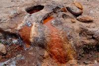
Tiracoma 1 (Lat. N 15o 41' 11.0", Long. W 70o 18' 59.6") is a gentle dome about 25 m in base diameter and 4 m in height. Its crater is of irregular shape, with length of 5 m and width of 1.5 m (Fig. 2). There is water in the crater and bubbling gases escape into the air intermittently. The pH has been measured at 6.87, and the water temperature at 12.9oC.
|
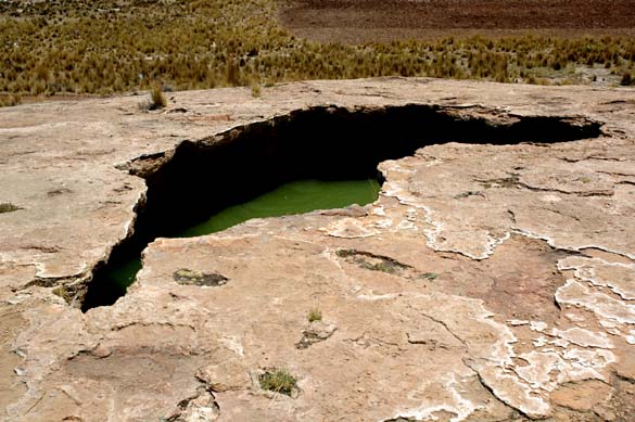
There is no evidence that liquids have flowed out of this volcano in the recent past. However, in the vicinity of the volcano, downstream of it, there is a large natural depression which is devoid of vegetation (Fig. 3). This indicates that the outflow from the volcano is saline, and that it has collected into the depression throughout geologic time by gravity flow.
|
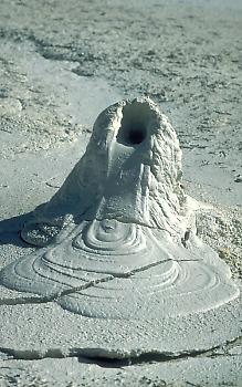
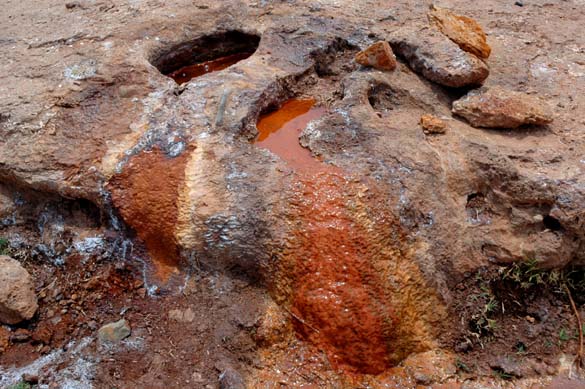
Tiracoma 2 (Lat. N 15o 41' 28.1", Long. W 70o 19' 32.6") is much smaller than Tiracoma 1, but it is currently spewing liquids and gases out of its small crater. Tiracoma 2 is an irregular dome about 3 m in base diameter and 0.6 m in height. Its crater is of nearly elliptical shape, with larger dimension 0.3 m and smaller dimension 0.15 m (Fig. 4). There is saline water in the crater and bubbling gases are constantly escaping into the air. The pH has been measured at 6.88, and the water temperature at 15.2oC. A small flow, estimated at about 0.2 liters per second, has been observed flowing out of the crater and spreading into the surrounding environment by gravity.
|
Figure 5 shows an image of the Pampas de Mañazo, showing the location of Tiracoma 1 and Tiracoma 2 mud volcanoes (marked with yellow pins). The gray area next to Tiracoma 1 is the barren area shown in Fig. 3. At least two other gray areas shown in this image may reflect the presence of additional mud volcanoes.
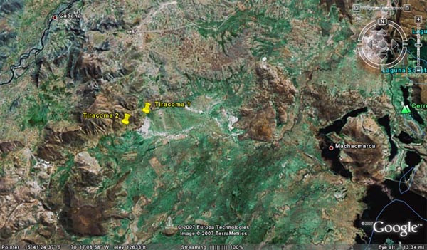
|
| Source: Google Earth ™ |
(bottom center). |
IMPACTS OF MUD VOLCANOES ON IRRIGATION
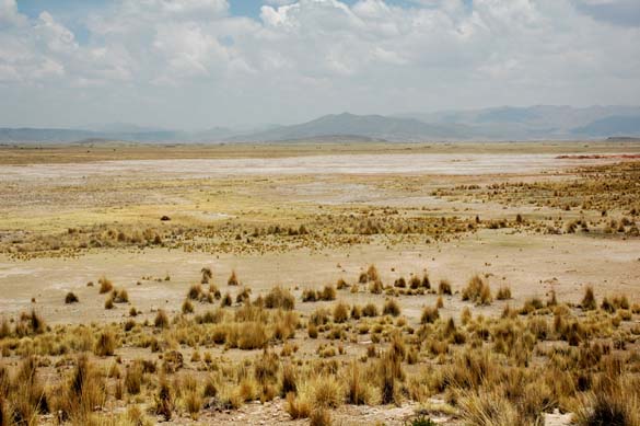
A major irrigation project is currently being developed in the Pampa de Mañazo, adjacent to the Tiracoma mud volcanoes and downstream of them (Pampa is Spanish for slightly undulating flatlands). The irrigation of Cabana-Mañazo conveys a flow of 10 m3/s from the intake at the Cabanillas river, a distance of 30 km for eventual delivery to the Pampas of Mañazo. The presence of the mud volcanoes in the area raises questions about the impact that they may have on the irrigation project.
Saline seeps and underground flows may underlie a portion of the pampas, as evidenced by the mud volcanoes. Still, there may be other mud volcanoes in the vicinity of Tiracoma and Mañazo. Thus, it is imperative that a management program be developed to cope with the possible negative impacts of these natural geological features. Saline flows will contaminate surface and groundwater and, without adequate drainage, may jeopardize the viability of the irrigation project. Detailed studies are needed to assess the importance of the threat and to develop remedial strategies.
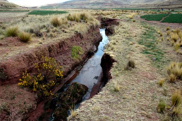
Outflows from the mud volcanoes will need to be carefully monitored, and the salinity of the surrounding surface and groundwater measured. Ultimately, the outflow from the active volcanoes will have to be routed around the irrigation area for delivery to appropriate drainage channels (Fig. 6). Discharge from these channels will ultimately flow into Lake Titicaca, the recipient of all surface drainage in the region. The impact that a concentrated saline drainage flow will have on the water quality of Lake Titicaca will have to be assessed carefully.
|