 Photo by Bartolomé Bossi (1863) |
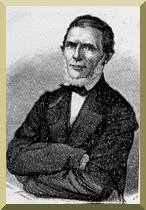
| Captain Augusto Leverger |
This article appeared in South American Explorer, No. 73, Fall 2003.
|
Photo by Bartolomé Bossi (1863) |
| Captain Augusto Leverger |
|
TRAVELS ON THE RIO PARAGUAY By Captain Leverger Abstracted and translated from the Portuguese original by Victor M. Ponce
|
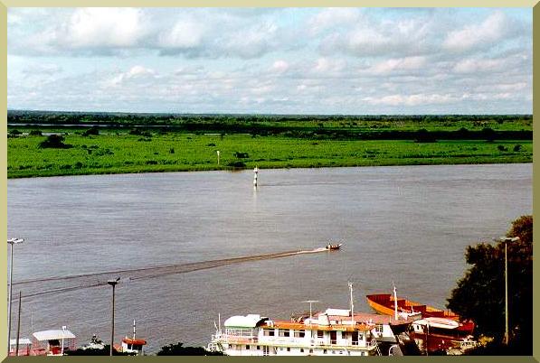
| In this article, Captain Augusto Leverger, of the Brazilian Navy, describes his travels on the Rio Paraguay, c. 1846. The article covers the river and its environs between Foz do São Lourenço and Foz do Apa, a distance of about 800 km along the central and southern portions of the Pantanal of Mato Grosso, Brazil. Leverger's account, while primarily descriptive of the river's main features, includes occasional pointed appraisals of the region's native peoples. The Pantanal, the largest wetland in the world, is currently being threatened by anthropogenic pressures; therefore, the need for its conservation is now more apparent than ever. |
|
Foz do São Lourenço
At the confluence of the Paraguay and São Lourenço rivers, there is a 2-mile long low-lying and seasonally flooded island, located between parallels 17o 55' and 17o 57'. It so happens that when the flood in the São Lourenço preceeds or exceeds that of the Paraguay, the latter's waters are repelled and the São Lourenço falls in two mouths, one to the north and another to the south of said island. The terrain on the left margin is sensibly flat and horizontal, excepting a small group of hills at a distance of 4 to 5 miles from the river bank, and another isolated hill referred to as Morro do Caracará, located on the right margin of the São Lourenço, almost one league upstream of its mouth. On the right margin, at a distance of 1 to 2 miles, there is a high and menacing range, which borders the Paraguay from the mouth of Lagoa Gaiba. The space between the river and the hills is very low lying, partly flooded, and cut by several small baías [natural channels which drain the swamps].1 The width of the river is greater than 100 fathoms;2 however, from here on downstream, there are many locations where it is much less.
Ten-and-a-half miles downstream of the mouth of
the São Lourenço, the hills on its right margin
approach the river at a point called Pedras de Amolar [Serra Amolar].
Five miles downstream, the river again
touches the hills at a place called Dourados, where we have a small
military post. This is a point of some importance for the policing of the river,
because it does not flood,
it can be fortified, and it has enough space to raise crops and cattle.
The vegetation that covers the hills is the same as that of the plains,
but to the west there
are some virgin forests. Behind the Serra
Dourados there is the
Downstream of Dourados, the Paraguay flows in ESE direction for 7 miles. On the right margin
there are two high and salient hills called Chanés, at a distance of
1 to 2 miles from the river bank. At the end of this stretch, on the left margin,
there is a baía of the same name, Chanés, which links with the São Lourenço through a
channel which enters that river downstream of Morro do Caracará.
From here on, for 7.5 miles, in aproximately southern direction,
there is a place called Tres Barras, so named because the river divides itself into two
branches and there is a baía on the left margin.
On the right branch, there is a series of hills which border the river on the place called
Laranjeiras, distant 7 miles from Tres Barras, and for 5 miles more downstream,
ending in the Morro do Sucuri.
Five miles downstream, in the latitude 18o 59', the Paraguay
bifurcates on its left margin into the Paraguay-mirim,
of mouth a few fathoms wide. The Paraguay-mirim meanders extensively through flooded plains
while being cut by many baías,
returning to the mother [Paraguay] after 33 miles in a straight line
and 55 miles following the curves. Here ends the district inhabitated by the Guató.
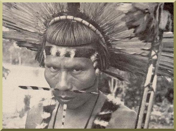
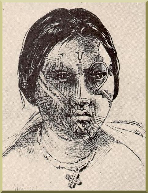
The Guatós
The Guató nation, numbering in the 400's, inhabit the Rio Paraguay from the mouth of
Lagoa Uberaba, and in the São Lourenço as far as the barra do Cuiabá [mouth of the
Cuiabá].
They navigate the rivers, lakes, and flooded plains between
parallels 17o 30'
and 18o 30'. It can be said that they have no
houses other than their canoes, which they themselves fabricate;
these are well made, small, leveled, and almost all of the same size.
When they stay for too long in any location, they quickly build, using local resources,
small ranches in which they sleep protected from the weather. They live from hunting and
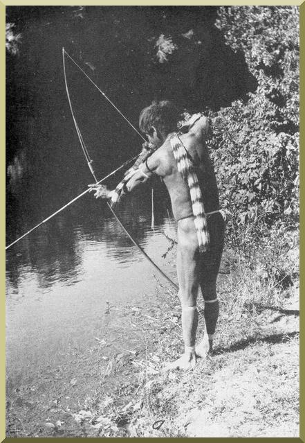
fishing, they have a 10-palm3 long bow and somewhat shorter arrows, which they
handle with admirable dexterity, even using them to kill fish. They also use them
as harpoons during the hunting of the jaguar, of which there are many in these lands.
The Guatós have as many women as they can maintain; in rare instances it is four women;
many of them are happy with one;
although I know of some that have ten or twelve. Contrary
to the Guanás and Guaycurús, they are very jealous. They do not have
the barbarous custom of killing their offspring. Each family lives isolated from others;
when they get together, it is for a short time.
Nothing special is noted in the semblance or stature of these indians, if only that they have their
trunk and legs bowed, as a result of being habitually in this position, rowing in their
narrow canoes. They have scarce beard, which they do not shave; they let their hair grow, which
the men tie around the top of their heads and the women keep loose. They usually go nude, covering only
their private parts; the women dress in cotton sayas; the men have mostly cotton pants or shirts, which
they down when in the presence of strangers. Most use an earring, regardless
of sex or age.
As with the rest of the neighboring nations, they have abandoned the old custom of perforating
the lower lip to place a piece of wood or bone. Even though their life is
mainly aquatic, they lack cleanliness.
The Guatós are trustworthy and inoffensive; however, they have shown in various
occasions that they can resent and even avenge provoked agression. I will cite an example:
two Guaná killed a Guató to steal some of his tools. Informed of the situation, the
commandant at Alburquerque [Corumbá]
ordered the assailants to be captured. When they learned the news,
the Guatós got together in Dourados where they waited for the canoe that
was transporting the prisoners, they then commandeered the canoe and, after reproaching them for their crime,
took their lives. And, as they delivered to the sargent the irons of the prisoners,
they manifested their desire to live in peace with us, and pleaded with
him not to interpret their punitive action as an act of hostility.
The language of the Guatós is gutural, lacking in euphonia,
and has no resemblance to the
lingua geral or guarani. Almost all adults speak Portuguese more or less
fluently.
As they see a boat, they approach it and accompany it, even until night falls,
hoping to receive some flour, salt, cigarretes, food scraps, and above all,
liquor. They also do business with our people, exchanging for said articles and for machetes,
harpoons, knives, cotton cloth, the products of their hunt such as jaguar, monkey,
otter, wax, edible resin, etc. Sometimes they offer themselves for work in the canoes,
and they are very useful, either for hunting and fishing or for directing the navigation on
flooded plains.
All the industry of these people consists of fabricating their canoes and oars
and the preparation of
their weapons. They also make coarse vases to cook their foods; and with threaded
tucum [palmae, palmeira] and pita [agave] they make mosquito nets.
Exceptionally, they will establish themselves in a definite place, where they cultivate
a few crops like corn, bananas, squash, etc; however, these plantations are usually insignificant,
not even covering their subsistence needs.
I have been purposely
somewhat extensive in my description
of these indians, since I have seen
that in no way do they fit the description made of them
by the writers that describe the indigenous people of this country.
Corumbá
Downstream of the bifurcation to the Paraguay-mirim, the Paraguay flows quite sinuously
in the SW direction until it reaches [Barra de] Castelo. This is the name given to a vertical rock, resembling
a ruined fortification, which is located
along the river bank on the right margin.
On the left margin, there is also a vertical rock formation, although much smaller.
In this place, the river flows along a narrow stretch 40 to 50 fathoms wide.
From Sucuri, and certainly downstream from Castelo,
high and mountainous lands, with wide openings between them, are seen on the right margin.
To the south are seen the tops of the serras do Albuquerque, which dominate the highland
on which they are located. The Paraguay, continuing to meander
extensively in mostly southern but also western direction, flows for a distance of 47 miles
from Castelo to hit perpendicularly the said serra at latitude
19o,
at the town of
Albuquerque, which some refer to as Corumbá.
This town was founded fifty years ago by the Captain Luiz de Albuquerque. Its position
is as advantageous as it is peaceful; the climate is healthy, the soil fertile,
it has good forests and plains for raising cattle, and hunting and fishing are extremely
plentiful.
The soil is calcareous, and it is here where the lime used in construction in the
capital originates. However, the town, instead of improving, is deteriorating. The two best
buildings, a small church and a military compound, are falling into disrepair; the population, which
is a little more than one hundred souls, lives miserably, barely satisfying their subsistence
needs.
The coast where the town is built extends about 12 miles to the west, forming a series
of hills, whose base is bathed by the waters of Baía Tamengos or Cáceres [now Canal Tamengo],
which drains the vast flooded plains of the northwestern quadrant [Bolivia].
The Rio Paraguay continues to abut the same coast, going east and a little to the south
for about 6 miles,
until it reaches the Ponta do Ladário; where they wanted at first to built the town;
and after 6 miles on the same direction, the river abuts with the northernmost point of
the Serra do Rabicho, whose direction is approximately from north to south.
From here, the river flows in ENE direction to meet in 3 miles
the downstream mouth of the Paraguay-mirim, which is of considerable width.
Ten to twelve miles north, there are several isolated hills or groups of hills, which during
floods appear as islands. There are situated on both sides of the Paraguay-mirim. There is also
a small hill in front of the town of Albuquerque. With these exceptions, all the terrain between
the Paraguay and the Paraguay-mirim is permanently or seasonally flooded.
Foz do Taquari
Downstream of the Paraguay-mirim, the river takes a SE direction, and after 7 mi
receives on the left margin the flow of the Formigueiro,
a branch of the Rio Taquari, whose main and southernmost mouth
is located 16 miles downstream, at a SSE direction,
at latitude 19o 15'.
The headwaters of the Taquari are opposite to those of the Sucuriu, a tributary of the Paraná;
the Piquiri, whose waters flow into the São Lourenço; and lastly the
mighty Araguay [Araguaia], one of the principal tributaries of the great Tocantins.
The Taquari receives on its left margin on latitude 18o 34'
the waters of the Coxim, in which descend the canoes which come from São Paulo by
Camapuã.
Downstream of this barra [sandbar] there is a waterfall, and from there on,
there are no obstacles to navigation. After
a distance of six leagues there is a chain of hills named Cavaleiros,
and not Rio Cavalleiros as shown in some maps.
More than 20 leagues before reaching the Paraguay, the Taquari, flowing on flat and low-lying terrain,
divides itself into many sinuous little arms; one flows into the Paraguay-mirim at latitude
18o 42'; another is the Formigueiro; a third keeps
its name of Taquari until its fall.
The other arms, after extensive courses, subdivide and form seasonal swamps which
dry out through evaporation. Nevertheless, some of these watercourses reunite again and enter the
Paraguay in many locations between the mouth of Formigueiro and the mouth of the Taquari proper.
The most notable of these channels is the Rio Negro, whose mouth is at latitude
19o 08'. The seasonal inundation covers the swamps, and in the proper season,
the canoes guided by experienced práticos [pilots] follow the plains'
watercourses and arrive at Cuiabá directly, without having entered the main channel of the Paraguay.
Downstream of the Foz do Taquari, at 14 miles toward the south and a little toward the west, enters
the Rio Mondego, formerly called Mbotetiy, Aranhahy, and presently better known
with the name of Rio Miranda. This river has two principal branches;
the southernmost, properly
the Miranda, upon whose margins is located the prison of the same name, and the parish of
Nossa Senhora do Carmo, with a population of 4000 individuals and close to 3500 indians
living in villages in the surrounding areas. The Rio Miranda is very sinuous, it lacks waterfalls,
but is very shallow in some areas. The other branch is the Aquidaunana, which flows
into the Miranda along its right margin. It has waterfalls only at its headwaters, which are opposite to
those of the Anhanduhy, which across the fields of Vacaria flows
into the Rio Pardo. It was through the Anhanduhy and Aquidauana that navigation was carried out
in the past between São Paulo and Mato Grosso. After this course was abandoned for a long time,
a few expeditions were made 8 to 10 years ago. They say that the principal inconvenience
is that the Anhanduhy is very shallow during the dry season. The margins of the Miranda are
subject to seasonal flooding for many leagues above its mouth.
In front of this barra [sandbar at the mouth], there are two conical hills along the right margin;
these form part of a small range which reaches close to the river bank.
The hills that can be seen from Rabicho end here.
Six miles below the mouth of the Miranda, there is an small hill along the right margin, which forms
a wall which abuts the river. Toward the north, at a 3-mile distance from the river, there is the parish
of Nossa Senhora da Conceição de Albuquerque. Twenty years ago there was not in this place
anything more than one Guaycurú village and another Guaná, for which
catechesis the Missão
da Misericordia was founded.
In 1827, the border military command was transferred to this location, and the population
grew in earnest. In 1835, the parish was inaugurated, which comprises Coimbra and the town of Albuquerque.
Its inhabitantes raise cattle, although at very small scale. The total
population is about 500 souls, besides some 1000 indians, most all from the Guaná
nation, which reside in two
villages, one next to the parish and another much greater at Mato Grande,
at a distance of 9 miles to the northwest.
The Guanás
The nation of the Guanás is one of the largest in these regions. They are divided into several tribes,
which have been considered by some writers as distinct nations. Some inhabit the republic of
Paraguay; others, still in the savage state, live in the Chaco, from Fecho dos Morros to the south.
Those that inhabit our territory are the terenas, the
laianas, the quiniquináos, and the guanás proper.
The terenas and laianas are living in the vicinity of our prison in Miranda.
The quiniquináos, which number more than 800 individuals, have a village at above mentioned Mato
Grande, 3 leagues NW of Albuquerque. They occupy themselves in the field and furnish this border region
with mandioca fluor and beans; they also grow sugarcane and rice. The village of the Guanás is less than
one mile from the parish; it currently has a few individuals; many of their inhabitants have left to form
another village along the margins of the Cuiabá, close to the city.
The indians of this nation are used to working as laborers; they exist in great numbers, spread throughout the city
of Cuiabá and surroundings. They are the ones who pilot a good portion of the canoes, making
themselves useful in navigation, both in the province's [Mato Grosso] interior and toward São Paulo.
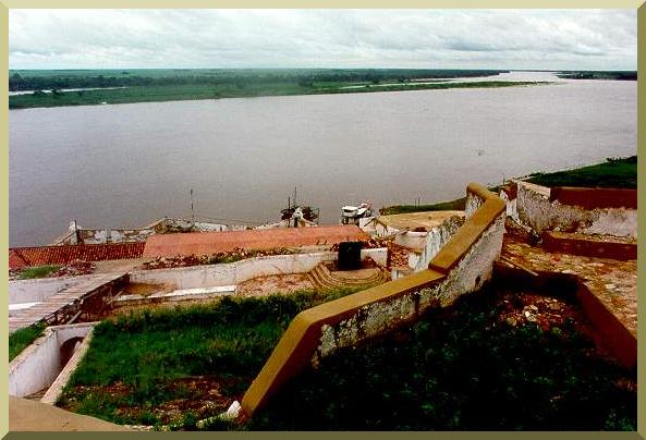
Forte Coimbra
Sixteen miles downstream of the port of Albuquerque there are a few hills referred to as Morro de Puga,
along the right margin and close to the river bank. They follow another larger hill referred to as
Morro do Conselho; which is at 5 miles from the former along the river bend, with 1 to 2 miles
of distance on a straight line. The river continues for about 22 miles in the SW direction until it reaches
Forte Nova Coimbra, founded in 1755 by Captain Luiz de Albuquerque.
Forte Coimbra is situated along the edge of the river, on a hillslope; it is 1.5-mile long
and a little more than 0.5-mile wide. Across the river is Morro Grande, whose base has about 2.5 miles
of circumference. The width of the river in this location is more than
200 fathoms and its depth is at least 30 palms.
The fortification, which is of irregular shape, consists of batteries with ten canon emplacements, which offer
cross fire on the river; and two small ramparts, whose walls are very low, as well as the
walls which join the ramparts. These are on horizontal terrain; the rest extends over the hill, along
steep slopes, and the interior of the fort remains completely open. There is no population in Coimbra;
only half-a-dozen huts along the bottom where the soldiers' families live. During floods, the neighboring
plains are inundated, and one could surround the hills of Coimbra from either of the
river's sides, in a canoe.
This is the main reason which some give as argument against the utility of the fortress.
However, I will point out that (1) the time in which this navigation can be performed is very limited;
and (2) that in order to be practicable for sizable vessels, the flood would have to be an
extraordinary one.
On the north face of Monte Coimbra there is a cavern commonly referred to as Buraco do Inferno
[Hell's Hole], to which entrance one arrives by climbing 150 to 200 steps along the hillside.
I will say little about this cavern, which has been elaborately and pompously described in several
old and modern accounts. It is an vaulted gallery, which at great slope enters into the mountain.
Its walls and floor are covered with unequal and rough rock protuberances, which separate more-or-less
profound cavities. In some places, the gallery is narrow and low; in others, it expands into spacious
salons adorned with a multitude of stalactites and stalagmites of curious aspect, although they have been much
mutilated by the hammer of visitors. In one of these salons there is a lake or large river, whose
waters are extremely clear and occupy the base of the area.
It appears that it does communicate with the Paraguay, since an alligator has been found in it;
also because its level goes up or down as the level of the river fluctuates.
Here I will make some observations relative to the Paraguay which I have already described.
With the exception of the already mentioned hills,
the margins of the river are flat, horizontal, seasonally flooded in many parts, and cut by a great number of
baías.
The mean height of the river banks is about 10 palms; in a few areas it exceeds 15 palms,
and it should be noted that the adjacent plain is lower than the bank top,
which forms along the river a narrow levee, and
the flood does not top the river banks until all adjacent floodplain has been already covered.
Grasses and other herbaceous plants constitute the principal cover of these floodplains,
along which are distributed, mostly along the river bank and baías,
capões [islands of predominantly woody vegetation] and restingas
[lateral dikes along rivers], shrubs and thickets.
The river is very sinuous until it reaches the town of Albuquerque;
its width varies between 50 and 100 fathoms.
From there on, the straight reaches are longer, the river width in many places exceeds 200 fathoms,
and in very few it is less than 70. In all places, during low flows, there is a channel with a depth
of 10 palms, although this channel is often very narrow. In order to navigate without difficulty,
the boat should not demand more than 6 palms of depth. 4
From Coimbra to the south, there is a noticeable change in the landscape;
the plains have less woody vegetation; the capões and restingas are rarer.
Forests of carandá palm begin to appear;
in some parts they grow together with other woody vegetation;
however, most of the times they do not allow other woody species to grow.
Salgueiros [areas with salt efflorescence] appear in the river beaches;
the straight reaches become longer; the width of the river in some parts exceeds 250 fathoms.
The Cadiuéos
From São Lourenço to Coimbra, the only indians inhabiting the land are the pacific Guatós,
and the semicivilized Guanás, which should not inspire any fear. However, south
of Coimbra, it is necessary
to exercise some caution. On the river, and along its margins, there are indians of many nations,
whose loyalty we should not trust, although rarely or never do they attack openly,
even though they may have a superior force. Those that are more frequently found are the treacherous
cadiuéos, whose malice has proved to be fatal in many occasions.
The cadiuéos are a tribe of guaycurús
or cavalleiros famous for the many and tough combats
in which they engaged the discoverers and first settlers of this province. The curious description
of this nation, and of its uses and customs, is told in much detail by Corographia Brasileira
and other publications.
In 1845, a group of cadiuéos and their chief Tacadauana came to Cuiabá
and manifested their intention to settle peacefully in Albuquerque. The government gave them
tools to raise crops. However, instead of engaging in work,
they sold the tools for liquor, and when one of them was assassinated, the rest retreated.
As with other tribes of their nation, the cadiuéos do not fix their residence;
they establish themselves temporarily, either here or there along
the margins of the Paraguay between Coimbra and Fecho dos Morros.
The cadiuéos
are at war with the enimas; therefore, they do not venture to the side of the Chaco, from
Olimpo to the south. Although there are principally horse riders, they also
possess canoes in which they sometimes travel.
Besides bows, arrows, spears and clubs, which are their usual weapons, they also employ
arquebuses, and there are some good shots among them.
I repeat that it is not likely that they will attack openly; rather,
it is against their untruthfulness that extreme caution is warranted. Many times, it was during
demonstrations of friendship that our people were attacked by them.
Thirty miles downstream of Coimbra, with the river flowing in general SW direction,
making a few bends and forming many islands, the huge
Baía Negra enters by the occidental margin; the latter is
considered by many maps a river due to its large size. From here,
the Paraguay river is the border between Brazil and Paraguay. Downstream of the mouth of Baía Negra,
the river makes two notable turns and reaches, after 22 mi, the Capão de Queima,
on the right margin, a place not subject to inundation. The chamococos
indians inhabit the right margin
in the vicinity of Baía Negra; these indians are shy and are rarely seen on the river banks.
The river continues south for about 15 miles until it reaches the mouth of the small Baía de Salinas,
so called because salt can be found in its margins. Next to it and close to the river is the Capão
de Salinas.
Forty miles downstream of Salinas, the river touches on its right margin the bank of Rabo d'Ema,
close
to which there is a great capão.
This place, as well as the Queima de Salinas, is frequently visited
by the cadiuéos.
In this stretch of 40 miles, the river flows along many bends, always following a general southern direction.
Several hills are seen on the left margin, more or less distant from the river; also seen are the great mountains
which limit the plains toward the orient. Almost 6 miles to the SE of Rabo d'Ema, along the left margin,
the stream called do Queima, do Paula, do Nabilecuega,
and named the Tereris by the
early explorers, enters the river.
In 1846 I explored this Riacho do Queima. It runs along clean plains, it is 30-40 fathom
wide at its mouth, and it is very deep; however, on ascending it, I saw its width
decrease to 10 or 8 fathoms, and
even less; and 2 or 3 miles before I reached a small hill, I had to retreat not finding more that one palm
of depth. There I encountered the hordes of the cadiuéos which I have
described earlier. It appears that these indians have resided in these areas for a long time, because
the names Queima and Paula
are those of the chiefs which in 1791 went to Mato Grosso to ask
Captain Luiz de Albuquerque for peace and friendship.
Two-and-a-half miles ahead, along the same margin [left], is the mouth of the Rio
Branco, as called by our pilots and the Spanish,
even though it is only a long and wide impediment. I navigated it for about 8 to 10 miles, without
noticing the minimum current, and retreated because there was not enough depth even for my
small canoe. The cadiuéos told me that a river which floods the fields
of the oriental margin, which they refer to as Branco [White] due to the color of its waters, spills
into the swamps before reaching the Paraguay. Others affirm that it is the same river which enters
the Rio Apa.
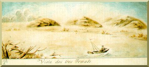
Five miles to the southwest of the aforementioned mouth, there is Forte Olimpo [Fuerte Olimpo],
formerly Bourbon,
on the right margin, on the bottom of a small hill, at the foot of three larger hills, which the Spanish
called Tres Hermanas [Three Sisters], and that formerly our people referred to as Morros de
Miguel José. This fort was founded in 1792. It is the northernmost military installation
of Paraguay.
I do not find any utility to that republic, other that to attest to the possession of the territory
on which it resides. It is constructed of local rocks. Its form is square, featuring a tower with three
canons on each corner. It is about 12 fathoms on each side. The walls are low, thin, and lacking in slope.
Its artillery consists of three pieces of iron, of caliber inferior to 12, and two small pieces of
artillery. There is not any town in the vicinity, its contingent of 30-50 persons
living in total isolation. Every two months a boat from Concepción brings supplies.
Fecho dos Morros
Thirty-two miles south of Olimpo is Fecho dos Morros,
formed by a group of large hills, which border
the left margin, and another one isolated on the bank of the right margin. In front of this hill,
there is an rocky island which divides the river into two channels, both navigable, even though the
entrance to the left channel is sprinkled with rock outcrops. One of the hills is notable due to its
height and its conical shape;5 it is called Pão de Açúcar
[Sugar Loaf]; the Spanish refer to this hill by the same name.
In this place, Captain Luiz de Albuquerque ordered the prison of Coimbra to be founded.
It is assumed, and this is also the opinion of Colonel Ricardo Franco, that Fecho dos Morros is the
southernmost limit
of the seasonal inundation and, therefore, that the boats that go up or down the river had to
pass through, under fire, the fortification that would be built here; that this fort would be
an obstacle to the flight of desertors and slaves and to any other hostile expedition which
came into this province.
I am inclined to believe that by the side of
the Chaco, the flooding covers much wider territory; and that the space between the hills on the left margin
and the high mountains toward the orient [serra da Bodoquena] is also seasonally flooded.
This is what Azara and other Spanish military
officials believe. However, Fecho dos Morros is still important
as a military location, because as I said earlier with respect to Coimbra,
only in rare occasions is navigation across the plains practicable, and only in small canoes.
Eleven miles south of Fecho dos Morros, there is a small hill called Batatilha along the left margin;
from its base it projects a restinga, which narrows the bed of the river; this place is referred to as
Passo de Tarumã, where until recently came enimas indians to exchange horses for cattle, which
was brought here from Miranda by our people. These enimas say that they are a tribe of the lengua nation.
The Paraguay continues in a southern direction
for about 7 miles, and it passes by Tres Bocas, formed by two islands
almost equally dividing the mouth. Eight miles ahead there is a baía on the left margin, and a few
small hills on the right margin, which are named Sete Pontas. This is where, according to the Spanish
colonel Jose Antonio de Zavala, the small river Tepoti enters the Paraguay.
The Spanish commissar Manuel Antonio
de Flores, which traveled these regions in 1752, places the mouth of this river at
21o 47'. Having observed the
latitude 21o 46' 50'' at the mouth of this baía,
I assumed that this was the mouth of the Tepoti. However, upon entering for quite a distance,
I did not sense any current at all.
I will add that the inquiries I made about said river where in vain, it not being known by the pilots
which I consulted; one of them is the commandant at Olimpo, who for many years traveled monthly
from Villa de Concepción to Olimpo. They say that a tribe of Guanás
lives on the bridge at Sete Pontas.
Foz do Apa
From here, the river flows pass extensive
lowlands with general direction to the south, flowing around bends
and forming several islands, until it reaches the mouth of the Rio Apa at latitude 22o 6', at a distance of 28 miles from Sete Pontas.
The Rio Apa, designated by some maps as Corrientes, is a left-margin tributary of the Paraguay;
on its mouth it distributes into two arms by a shallow island of small length; above it is about
40-fathoms wide, with a deep although very narrow channel. I am informed that several
rock outcrops impede navigation on this river.
Although no treaty has fixed the limits of the Empire [Brazil], at this point
factually comes to an end our domain over the left
margin of the Paraguay, since the Paraguayans are actually in possesion of the territory south
of the Rio Apa;
on its margins they have founded and keep some military establishments. It is also,
in my view, at this latitude that the extensive plains which are flooded annually by the
periodic rainfall and by the spilled waters of the Paraguay come to an end, which has been
referred to by the
geographers as the Lago de Xaraiés.
Now, some retrospective observations are in order.
The rainfall season,
on the headwaters of the Paraguay and its tributaries, usually starts in October and finishes in
April. The flood occurs from January to July, after which the waters start to recede until the following
year. However, the flood does not happen at the same time every year; sometimes the rainy season is delayed
and the flooding is delayed accordingly. It is evident that the volume of the flood, depending on the
abundance and duration of the storms, is also subject to wide variations. There are years in which
the Paraguay, through most of its course, does not spill over its banks and only the lowest lying
segments of the terrain are inundated. In other years, the entire flood plain is inundated.
They say, and I believe, that there have been floods which elevated the water level
up to 30 palms above the low waters.6
I consider, however, such floods as extraordinary.
I believe that usually the aforementioned difference in level
does not exceed 15 palms, but this is enough to assure that very few places are left
without complete flooding. With respect to the inundated area, which starts at the mouth of the
Rio Jauru,
close to the parallel at 16o 22',
it is not possible for me to exactly describe its lateral limits.
However, I will say that at the latitude of the São Lourenço, the flooded area covers from 60 to 80 miles
on the left margin; same on the latitude of the Taquari; from there toward the south it is
progressively less wide, and below Fecho dos Morros it does not exceed a few miles. Along the right margin,
the high hills which border the Paraguay do not let the flooding extend too much, although south of Coimbra
the width of flooded plains adjacent to the river begins to increase. During the dry season,
there remain on both sides of the river innumerable deposits of water; some resemble lakes, other resemble
true rivers which meander through the plains.
In general, the air temperature is above 80oF during the daytime,
and sometimes it exceeds 90oand even 95o;
during the cold season it decreases to 55o.
The river temperature is 76o.
A fact which appears to me singular
is the general healthy condition of this region. Malaria, which is present in the banks of the
Guaporé and other tributaries of the Amazon, is unknown in the Paraguay and its tributaries.
Only in rare occasions are the people of these regions attacked by illnesses which are typical of countries
with humid climates and high rates of biological decomposition.
The width of
the river, downstream of Coimbra,
varies from 100 to 300 fathoms with few exceptions, and the channel is always appropriate
for navigating vessels which demand less than 10 palms.
The speed of the current is 0.5 mph;
during flood, however, it increases markedly, and may sometimes exceed 2 mph.
In these
occassions, dikes formed by fallen trees, aguapés and other aquatic plants, and even
dislodged portions of river banks, with their grasses and shrubs still intact, are frequenty seen
traveling downstream, carried by the swift current.
Often these floating islands occupy almost the entire width of the river.
|
|
Victor Miguel Ponce
teaches civil engineering at San Diego State University,
specializing in hydrology. He has extensive experience with South American rivers,
having played a key role in several studies, particularly of the Paraguay river.
A regular contributor to South American Explorer, he welcomes visitors
to his website http://ponce.sdsu.edu
Acknowledgments: Maria de Fátima Costa: Cuiabá: Rio, Porto, Cidade (Prefeitura Municipal de Cuiabá) for Leverger's photo, and História de um país inexistente (Kosmos, São Paulo) for Miguel Ciera's paintings; Hugo Benito for hydrologic units of measure; and Catia Nunes da Cunha for translation accuracy. Reference: Leverger, A., 1862. Diario de reconhecimento do Rio Paraguay. Revista Trimensal do Instituto Histórico, Geográphico, e Etnográphico do Brasil, II trimestre. 1 Abstracter's notes are placed within [ ]. 2 1 fathom = 1.671 m; also 5.0 to 5.5 ft (archaic). 3 1 palm= 0.21 m. 4 Compares well with the 1.2-m self-dredging depth of the Paraguay river. 5 With apex at Elev. 410 m (above sea level) (International Travel Maps). 6 The recorded maximum difference at Ladario, near Corumba, is 7.23 m, based on records of the last 100 years.
|