|
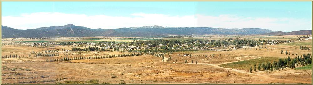
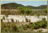
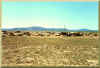
Fig. 1 Panoramic view of the Ojos Negros valley,
Baja california, Mexico.
SUSTAINABLE MANAGEMENT OF WATER IN THE OJOS NEGROS VALLEY,
BAJA CALIFORNIA, MEXICO
The Ojos Negros Research Group
San Diego State University
Universidad Autónoma de Baja california
Instituto Nacional de Investigaciones Agrícolas, Forestales y Pecuarias February 2003
|
|
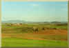
Fig. 2 View of the valley from the northwest corner,
with
Cerro Dona Eulalia in the background (right).
|
|
1. INTRODUCTION
1.1 Background
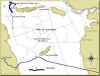
The Ojos Negros valley is located in Baja california, Mexico, about 80 km
south of the U.S.-Mexico border (San Diego-Tijuana).
The predominant economic activities in the valley are agriculture
and animal husbandry. Recorded human settlement originated
with the discovery of gold mining in 1870.
After a few years of productive gold mining, the local economic
activities shifted first to animal husbandry and later to agriculture.
At present, agriculture is the most important activity in the valley.
The importance of the Ojos Negros valley as a regional economic resource
with significant transborder effects is widely recognized.
The products of its irrigated agriculture,
which include alfalfa, green onions, onions, watermelons and other staples,
are commercialized on both sides of the U.S.-Mexico border.
About 2,000 people are directly dependent on the economy of the valley.
The name "Ojos Negros," which means "Black Eyes"
in Spanish, is mentioned in a map of the valley dating back to 1864
(Fig. 30),
in reference to two oval-shaped marshes closely resembling
two black eyes,
along the southwestern edge of the valley (Minnich and Franco, 1998).
These marshes have now all but disappeared due to groundwater depletion,
and only the name remains to bear lone witness of a wetter past.
As irrigated agriculture expanded in the valley, increasing demands have taxed
the local groundwater resources and the question of overexploitation vis-à-vis sustainable
management
has arisen. In the past 30 years
of agricultural expansion, institutional water management in the valley has been mostly
lacking. In search of the facts about
groundwater depletion, the Comisión Nacional del Agua
(National Water Commission of Mexico), completed a hydrogeologic study of the Ojos Negros aquifer
(Comision Nacional del Agua, 1997).
This study is disciplinary in nature; therefore,
it does not deal with the broader issues pertaining to the climatological,
ecological, economic, social, and institutional impacts of groundwater depletion.
The Ojos Negros aquifer is the only source of water
for the current agricultural activity in the valley.
The aquifer comprises a
surface area of about 100 km2, with a total volume of
388 hm3
(1 cubic hectometer or hm3 is equal to 1 million cubic meters).
The Comisión Nacional del Agua (1997) has calculated the mean annual overdraft in Ojos
Negros at about 6.5 hm3.
This calculation is based on 25.1 hm3 of aquifer
discharge through pumping and an estimate of 18.6 hm3
of natural recharge, which comprises net lateral flow (11.8 hm3)
(recharge 12.2 hm3 minus discharge 0.4 hm3)
and percolation
from rain and irrigation (6.8 hm3).
This overdraft is responsible for the depletion of the water table,
which ranges from less than 1 m to a maximum of about 13 m, amounting to a spatial
average of 0.32 m yr-1.
For purposes of comparison, the Plan
Nacional para Combatir la Desertificación en Mexico
(National Plan to Combat Desertification in Mexico) has placed the
mean annual overdraft in Ojos Negros at 0.52 m (Secretaría de Desarrollo Social, 1993).
The protracted groundwater depletion in the Ojos Negros valley
has measurable effects on the climate, soils, vegetation, economy,
and other components of the valley's ecosystem.
The complexity of the problem requires an interdisciplinary approach to the
management of the water resources of the valley.
The aim is to document the climatological, hydrogeological
and ecological dynamics resulting from aquifer overexploitation,
in order to support a strategy of sustainable
management which makes technical, economic, and social sense.
1.2 Objectives
The objectives of this study are the following:
- To document hydrogeologic, soil, vegetation, land-use, economic,
social, and other relevant data to support
continuing interdisciplinary research in the Ojos Negros valley.
- To study the climatology of the valley to assess possible
climatic changes which may be due to anthropogenic effects.
- To assess land-use changes using modern techniques of remote sensing.
- To develop an agricultural database suitable for studies of
groundwater depletion.
- To develop a GIS-hydrogeologic model suitable for application to the
Ojos Negros valley.
- To couple the agricultural database with the GIS-hydrogeologic model
to study the economic and social impacts of groundwater depletion.
- To examine the issue of sustainable water management
as it relates to the Ojos Negros valley.
|
|
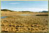
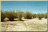
Fig. 3 Surface outlet of Ojos Negros Creek.
|
|
2. PHYSICAL SETTING
2.1 Physiography
The Ojos Negros valley is located in the state of Baja california,
Mexico, approximately 40 km (25 mi) east of Ensenada along the Mexico 3 highway
(Fig. 4).
The valley is drained by Ojos Negros Creek, a tributary of El Barbon Wash.
In turn, El Barbon Wash is a tributary of the Guadalupe River,
which exits to the Pacific Ocean at La Mision (La Mision de San Miguel Arcangel),
42 km (26 mi) north of Ensenada.
The drainage area of Ojos Negros Creek is 173.4 km2,
while that of El Barbon Wash,
measured at the narrow gorge (Fig. 9) located
approximately 3 km north (downstream) of Real del castillo Viejo, is 1,094 km2
(Ponce et al., 1999).
|
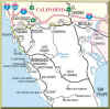
Fig. 4 Geographical location of Ojos Negros in Baja california.
|
The Ojos Negros valley is wholly contained within the drainage area of
Ojos Negros Creek. The valley is a natural depression of
roughly rectangular shape, bounded by mountain ranges on all sides,
of approximately 113 km2
and contained within 31o 52' and 31o
57' north latitude and 116o 12' and
166o 19' west longitude.
The terrain elevation (Fig. 7)
varies from 720 m at the entrance to the valley,
on the northeastern edge, close to El Barbon Wash (Fig.
19), to 670 m at
the mouth of the valley (Fig. 3),
in the vicinity of the junction between
Ojos Negros Creek and El Barbon Wash. The average elevation is around
705 m, and the valley slopes generally from east to west, between 0.5 and 1 percent.
|
Fig. 5 Detail of the Ojos Negros Valley.
|
The valley is readily accessible from Ensenada
via a two-lane paved federal highway (Mexico 3) which connects
Ensenada with San Felipe, on the Gulf of california.
Several unpaved roads transverse the valley in general N-S and
E-W directions. These roads often become impassable during the rainy season.
2.2 Geology
The Ojos Negros valley is a post-Miocene depression
surrounded by highly metamorphosed prebatholithic rocks such as schist and
gneiss. In addition, there are intrusive igneous rocks such as tonalite,
granodiorite, and gabbro. The entire region belongs to the
Alamo block, which contains a swarm of igneous dikes.
Weege (1976) has performed a geologic interpretation of the Ojos Negros valley (Fig. 6). The
structural setting is a graben, i.e., a depression bounded
between two faults. The relief is flat, with several hills and
ridges of metamorphic and igneous rock protruding along its borders
and in certain places on the valley floor (inselbergs).
|
Fig. 6 Geologic sketch of
the Ojos Negros Valley.
|
The gneiss and schist are of pelitic and basic-rock parentage,
regionally and contact metamorphosed by several plutonic
thermal events. Gneiss forms a ridge 2.5-km long, which rises 90 m above
the valley floor in the south-central part of the valley
to form the Cerro Doña Eulalia (Fig. 5).
The schists are of three different types. The first type grades
from an albite-epidote hornfels facies to a greenschist facies. It forms
the majority of the 350-m high fault scarp on the west side, the
majority of the south end, a large portion of the east central side,
most of the northern side, and about half of a ridge and a hill in the northeastern part.
The second type, talc schist, is a hydrothermal alteration of the
first type of schist. The talc schist forms a ridge 100-m high and
5-km long in the northwest side of the valley, known as Cerro
Portezuelo or Cerro Del Talco (Fig. 5). It also forms several small
patches on the NW side of the valley, which are
approximately in line with the larger ridge (Cerro Portezuelo).
The third type of schist occurs in a pedimented lowland area
in the NE part of the valley. It is composed of weakly metamorphosed
sedimentary rocks, which still show original bedding in most places.
The parent rock was the second type of schist (the talc schist)
and the tonalite (see the next paragraph).
There are four igneous rock types in the valley.
The oldest is tonalite, which forms several small hills about 50-m high at the south
central end of the valley. It also forms the majority of the
southeastern side and a part of the northeastern edge. The tonalite
shows deep weathering, and it is pedimented in the southeastern edge of the valley.
The second igneous rock is granodiorite, which intruded after the tonalite.
The granodiorite forms part of the southwestern fault
scarp, a ridge and several hills on the east-central edge of the valley,
a portion of the northeastern edge, and part of a ridge and a
small hill in the northeast.
The third igneous rock is the dikes, which are of three types:
(1) metarhyolite, (2) aplites, and (3) pegmatites. The metarhyolite
forms an impressive swarm on the northeastern side of the valley,
and on the west side along the fault scarp. The dikes are found in
other parts of the valley as single dikes or in small groups.
The metarhyolite swarms have a general N-S trend and are of Mesozoic
age; the aplite and pegmatite dikes are found in all orientations,
and intruded later. Some of the dikes are very large, being up to
13-m wide and up to 5-km long. The metarhyolite dikes are more
common than the aplites, and the pegmatites are relatively
rare compared to the aplites.
The fourth igneous rock is the gabbro, which appears to have intruded last.
The gabbro forms three bodies, which are about 250-m
high and up to 3-km long in the southeastern end of the valley.
It also forms four hills and five dikes that strike about N 20o W,
and are vertical on the east-central side of the valley, and a small body
on the northwest side. The gabbro is very dark in color
and it is readily identifiable in the field.
The main structural feature in the area is an almost-vertical-dip slip
fault on the west side of the valley. This fault trends about N
20o W, forming a 350-m high scarp. The second fault is along the
northeastern side of the valley, and trends approximately N 60o
W. It swings around in the northern part of the area until it is
heading about N 80o and meets the first fault.
These two major faults confine the graben and
are responsible for the topographic depression of the valley.
The sequence of geologic events in the Ojos Negros valley have been described by Weege (1976) as follows:
- The schists and gneiss were formed by plutonic-thermal
events which accompanied the intrusion of tonalite.
- Later, in the north-central area of the valley, a hydrothermal
alteration took place, and some of the schist converted into serpentine and talc.
- These events were followed by an erosional period in which
sediments derived from the tonalites and the schists were deposited.
- The tonalites and schists were then altered by a low-temperature
regional metamorphism and by the intrusion of
granodiorite to form the low metamorphic-grade bedded schists.
- During the Mesozoic,
the granodiorite intrusion was followed by a metarhyolite dike swarm, which was then followed by
aplite and pegmatite dikes that crosscut the earlier
metarhyolite swarms in many places.
- Following the intrusion of the dikes, small plutons and a
few dikes of gabbro intruded the area. The gabbro dikes
crosscut the granodiorite, while the gabbro itself has no dikes.
- A period of faulting followed, which resulted in the subsidence of the valley.
The forces that formed the graben were probably caused by tensional stresses associated with the
expansion of the protogulf of california.
- The graben underwent further hydrothermal alteration,
including the placement of calcite in fault fracture zones.
- During the Quaternary, the valley has pedimented and alluviated
to its present state.
|
Fig. 7 Digital elevation model of the
Ojos Negros Valley
(elevations in m).
|
2.3 Climate
The valley of Ojos Negros has an arid climate,
with rainy season in the winter (November to April), and extreme
temperature variability. The climate is characterized as cold
and humid in the winter, and hot and dry in the summer.
According to Koppen's climatic classification, modified by Garcia (1981),
the climate at Ojos Negros is of type BSh(s)(e').
The ecosystem associated with this type of climate and geographical location
is commonly referred to as "Mediterranean,"
which prevails throughout coastal northern Baja california and coastal Southern california.
The climatological station at Ojos Negros operated
between 1948 and 1995, with several interruptions of up to
one year. The following climatic variables were measured daily:
(1) precipitation, (2) actual temperature, measured at 7 am, (3)
maximum temperature, and (4) minimum temperature.
The distribution of monthly temperature throughout the year is unimodal, i.e., there is typically
only one maximum and one
minimum. Mean annual temperature is 18.6 oC. The mean temperature of the
hottest month (July/August) is 26.3 oC. Mean annual
precipitation is 240 mm, with 46 mm (20 percent)
occurring in the wettest month (January) and 0.6 mm (0.25 percent) in the
driest month (June).
The precipitation is markedly seasonal, with most of the precipitation
occurring in the November-April period. The number of
days per year when rainfall exceeds 0.1 mm (an indicator of the number
of storms per year) ranges from 20 to 40.
2.4 Soils
The soils of the Ojos Negros valley are under the influence of the
Mediterranean-type climate: cold and humid in the winter, and
extremely hot and dry in the summer. Thus, the soils in the
valley feature the geochemical process of rubefication, which, by
loosening (dehydration) of amorphous iron oxide, gives the soil
a characteristic reddish color. These soils are classified as
Inceptisols and are localized in the piedmont of the formations of gabbro, schists, and gneiss.
Another soil type, of alluvial and eolian origin, is classified as
Entisol and located toward the center of the valley. This soil is
of light gray color, low in organic matter, average texture, and readily erodible.
The soils of the valley are being intensively utilized by an irrigated
agricultural practice which uses high technology (sprinkler and
drip irrigation) and relies almost exclusively on ground water. The crop cycles
are short, extensive areas are kept in fallow, and there is a
lack of provision against erosion (from water and wind), which may be
affecting some areas. In addition, incipient gully
development, apparently due to overgrazing, is a problem in an area located
immediately east of Cerro Doña Eulalia.
The soils in the Ojos Negros valley are of alluvial, colluvial, aeolic, and lacustrine origin.
The alluvial soils have been deposited as sediments of the Arroyo El Barbon, and they
were formed during the Holocene and Quaternary periods. The oldest deposits are located south of the
Cerro del Talco, at the present location of the INIFAP Experiment Station. This soil is characterized
by a gray yellowish color, a presence of primary minerals, and mixed with angular boulders.
The intermediate-age deposits are located south of the Arroyo El Barbon; the soil profile is completely sandy,
with medium to coarse sands. The younger deposits are located on the Arroyo El Barbon, and are a result of the
sediment load originating by weathering of the rocks in the sierra Juarez.
The colluvial soils are located on the piedmont of the sierra limiting the west side of the valley,
on the principal fault, occupying a narrow band between 100 to 150 m in width, with slopes of 15 to 25%.
This soil is represented by a shallow profile, with incipient soil development, with grayish reddish colors,
which indicates the presence of iron oxides. A similar type of soil is found at the piedmont of Cerro Doña Eulalia.
The aeolian soils occupy the central to southern portions of the valley, they cover an extensive area, and their principal
characteristic is the deposition of wind-blown sands in the southwestern to southeastern direction. Its
physiography is that of low hills, with slopes between 5 and 10%, light colors, and great reflectance.
These soils were originally developing by sedimentation over
metamorphic rocks, with a light gray color, without the presence of clays;
now it appears that the profile is largely of an aeolic origin. Unlike the central portion of the valley,
no aquifers are located in these aeolic soils. Protection of these soils is necessary to mitigate the negative effects of sand
deposits originating in the sierra Juarez.
The lacustrine soils are located on a small stretch to the west of the valley, at elevations between 660 and 690 m.
The soil profile shows gleization, i.e., the presence of a water table and associated fluctuations.
Its colors reveal large variations in the redox potential, and its low density and high organic matter content
are a relic of more wetter past. These are the areas where the aquifer came to the surface prior to the onset of
sustained pumping for agricultural purposes (the 1970's).
2.5 Surface Water
The Ojos Negros valley is wholly contained within the drainage basin of
Ojos Negros Wash, a tributary of El Barbon Wash. The
latter is a tributary of the Guadalupe River, which flows directly to the ocean.
The valley has an area of approximately 100 km2;
Ojos Negros Wash has a drainage area of 173.4 km2.

|
Fig. 8 El Barbon Wash.
|
El Barbon Wash drains the Juarez Range (Sierra Juarez in Spanish) to the east.
The drainage basin of El Barbon Wash, up to the narrow
gorge located about 3 km downstream of Real del castillo Viejo, is 1,094 km2
(Ponce et al., 1999).
Downstream of this narrow gorge, El Barbon
Wash winds through several steep canyons (Ca˜on Hondo and Ca˜on Agua Caliente)
for about 15 km until it joins the valley of
the Guadalupe River.
El Barbon Wash lies between 31o 51' and
32o 11'
north latitude, and 115o 52'
and 116o 23' west longitude. The elevation varies
between 1820 m in the headwaters and 590 m at the basin outlet. El Barbon Wash
originates in the vicinity of Laguna Hanson,
which at an elevation of 1620 m, is the only freshwater lake in Baja California.
As it flows down the Juarez Range, the wash
receives the contributions of several important tributaries, among them,
Los Barrancos and El Ranchito
(Ponce et al., 1999).
|
Fig. 9 Outlet of El Barbon basin,
3 km north
of Real del Castillo Viejo.
|
After receiving the contribution of El Ranchito, El Barbon Wash flows down the
mountains and then tangentially to the Ojos
Negros valley, continuing straight west toward the Real del Castillo Viejo valley.
The reason for this unusual drainage pattern is
the presence of Cerro Portezuelo separating the two valleys: Ojos Negros to the south
and Real del Castillo Viejo to the north.
Thus, while El Barbon Wash delivers surface and subsurface water to both valleys,
the amount of surface water entering the Ojos
Negros valley is limited.
The delivery of water from El Barbon Wash to the Ojos Negros valley occurs through
the surface and subsurface. Since El Barbon
Wash is an ephemeral stream, overflows from El Barbon Wash, exclusively from floods,
enter the Ojos Negros valley through a
2.5-km long opening between the extension of Cerro Portezuelo to the west and
Cerro Las Flores to the east (Fig. 7).
Subsurface water,
which is a characteristic of washes/arroyos in arid regions, flows intermittently
from El Barbon Wash to the Ojos Negros valley,
feeding its aquifer. The amount of water delivered to the valley on an annual
basis depends on the pattern of floods, the
infiltration properties of the streambed and its vicinity, and the
transmissivity characteristics of the aquifer.
|
Fig. 10 Streambed of El Barbon Wash.
|
The climate of El Barbon basin ranges from semiarid to arid, whereas that of the
lower valleys (Ojos Negros and Real del Castillo
Viejo) is predominantly arid. In the mountainous portions of the basin, mean
annual precipitation is 475 mm, based on 15 yr of
data at San Juan del Dios Norte (1970-84). In the Ojos Negros valley, mean annual
precipitation is 245 mm, based on a 49-yr
average (1948-96). The mean annual precipitation for El Barbon basin as a whole
is estimated to be about 440 mm, which
amounts to an annual moisture supply of 480 hm3
(Ponce et al., 1999).
The predominant vegetation in the basin is chaparral in the lower and intermediate
elevations (600-1600 m) and evergreen pine
forest in the higher elevations (1600-1800 m). The predominant land use is pasture,
except in the valleys, where intensive
agriculture is practiced.
To this date, El Barbon Wash remains ungaged. The mean annual runoff coefficient
has been estimated as 0.1, judging from data
in neighboring basins of similar climatological, physiographic, and vegetative
features (Ponce et al., 1999).
This amounts to a mean annual runoff
(surface water) of 48 hm3, which could be substantially reduced if channel
abstraction and related groundwater replenishment is
actually shown to be significant.
Using mean annual precipitation and temperature data at Ojos Negros for the
period 1970-94, the Comisión Nacional del Agua (1997) has calculated the
mean annual actual evapotranspiration (AET) in the valley to be 360 mm.
By comparison, potential evapotranspiration (PET) of
a chaparral ecosystem is around 750 mm. The positive difference between
AET (360 mm) and rainfall (245 mm), amounting
to 115 mm, reflects the additional moisture introduced into the system by
groundwater extraction. The small difference, compared
to the consumptive use of water, is attributed to the irrigation operation
not comprising the entire study region.
2.6 Groundwater
The Ojos Negros valley is wholly contained within a graben. The depression,
with a surface area of about 113 km2, is bowl-shaped
and filled with alluvial materials, ranging from sand and gravel in the
northern half to silts and clays in the southern half.
Unlike the silts and clays, the relatively high hydraulic conductivity of
the sand and gravel makes them ideally suited for aquifer
exploitation. According to Comision Nacional del Agua (1997),
the aquifer proper in the Ojos
Negros valley has an area of 49.7 km2, mostly in the
northern half. Water for irrigated agriculture is drawn exclusively from this aquifer.
A small percentage is used for domestic needs.
The water table elevation varies from about 715 m at the valley entrance,
west of Cerro Las Flores, to about 665-670 m at
the valley exit, immediately west of Cerro Portezuelo. The elevation of the
water table is dynamic, changing in space and time
with pumping and replenishment. To illustrate, by February 1997, with pumping
continuing unchecked, a substantial portion of
the western half of the aquifer had been depleted to 665 m (Comision Nacional del Agua, 1997).
The aquifer thickness varies from 14.5 to 216 m, with a mean of 78.2 m.
The transmissivity and coefficient of storage are 0.0091
m2 s-1 and 0.1, respectively.
The total volume of aquifer storage is about 388 hm3
(Comisión Nacional del Agua, 1997).
|
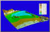
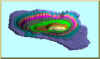
Fig. 11 Tridimensional view of the Ojos Negros aquifer.
|
The Ojos Negros aquifer is supplied from several sources, which include:
- Horizontal recharge, consisting of surface and
subsurface flow from El Barbon Wash, at the valley entrance on the northeastern
edge of the valley, and distributed subsurface
flow from the upper basin of El Barbon Wash, predominantly from an eastern direction;
- Vertical recharge, consisting of
percolation from irrigation (in excess of consumptive use), and percolation from precipitation.
Natural aquifer discharge occurs in two modes:
- Concentrated horizontal,
at the mouth of the valley, driven by existing
potential gradients.
- Distributed, along the perimeter of the valley.
The amount of distributed aquifer discharge is difficult
to quantify directly; therefore, natural aquifer discharge is taken as the
concentrated horizontal discharge at the mouth of the
valley.
There are more than 200 pumping sites in the Ojos Negros valley,
but only a third of them remain active.
The active pumps tend to concentrate
around the central portion of the valley; therefore, aquifer depletion is highest there.
The Comisión Nacional del Agua (1997)
has calculated that there is
12.2 hm3 yr-1 of horizontal recharge (+),
6.8 hm3 yr-1
of vertical recharge (+), and 0.4
hm3 yr-1 of
horizontal discharge (-). This results in a net recharge
value of 18.6 hm3 yr-1.
In 1997, the withdrawal by pumping
was measured at 25.1 hm3 yr-1.
The difference between pumping withdrawal
and net recharge constitutes the overdraft, which is
equal to 6.5 hm3 yr-1, i.e.,
an equivalent 0.32 m yr-1 of average water
table depletion for the Ojos Negros aquifer.
2.7 Water Quality
Like surface-water basins, groundwater basins are either exorheic or endorheic, i.e.,
they drain fully or hardly at all. Because of
the finite recycling time, an exorheic aquifer has generally good water quality,
particularly with regards to its salinity.
On the other
hand, the water quality of an endorheic aquifer is often too poor for practical use.
The Ojos Negros aquifer, while not being fully
exorheic because of its topographic/geologic setting (its graben setting and bowl shape),
it is nevertheless not completely endorheic,
since it has a naturally occurring and measurable horizontal discharge.
Thus, the water quality of the Ojos Negros aquifer does not
appear to limit its economic use.
The concentration of total dissolved solids (TDS) in the period
1989 varies from 437 to 1,832 ppm, with an average of 722 ppm
(Comisión Nacional del Agua, 1997). The higher concentrations, greater than 1,000 ppm,
are located immediately northeast
of the town of Ojos Negros, where the
water table has been depleted the most.
The lowest concentrations are located elsewhere in the valley, with values ranging from
437 to 877 ppm, and an average of 686 ppm.
Since the TDS for the ground water in the Ojos Negros aquifer is about 800 ppm,
it is classified as slight to moderate according to restriction of use.
|

|
Fig. 12 Office building of Ejido
Real del Castillo, in Ojos Negros.
|
|
3. SOCIAL AND
ECONOMICAL SETTING
3.1 Historical Setting
The development of the Ojos Negros valley is linked to the history of the
valley of San Rafael and the town of Real del Castillo, in the
municipality of Ensenada, Baja California. Over the years, the portion of
the San Rafael valley south of Cerro Portezuelo became
known as the Ojos Negros valley, and the main wash (San Rafael Wash) became
El Barbon Wash (Fig. 8).
The San Rafael valley is located in the lower elevations of the Pacific
drainage of the Sierra Juarez. According to Martinez (1937), in the 19th century, several
springs used to augment the flow of San Rafael Wash.
The latter flows into the Guadalupe River, which exits into the
Pacific Ocean at La Mision San Miguel de la Frontera,
42 km north of Ensenada de Todos Santos, now simply Ensenada.
In his detailed account of the early history of Real del Castillo,
Padilla Corona(1999) mentions that in June 1870, the brothers Ambrosio and Manuel del Castillo discovered
gold in the north part of the valley of San Rafael. The July 21, 1870 issue of the San Diego
Union, in California,
has the following note:
We have noticed that the mines are in the valley of San Rafael,
in Baja California, at a distance of 120 miles (sic) from
San Diego, and that these mines promise to be as rich and as extensive as
any of the mines known in past times in
California ...
The discovery of gold led to a renewed influx of people to the region,
and in September of the same year, a group of 112 settlers formally requested lands from the government.
The town of Real del Castillo was oficially founded on October 2, 1870 by the political
authorities of the time.
Meadows (1985) mentions that Real del Castillo grew around the
banks of San Rafael Wash. The arrival of foreigners led to other economic
activities, including commerce, agriculture, and
ranching. In 1877, the Norwegian rancher J. B. Hanson purchased a parcel
of land in the vicinity of "La Laguna," in the
headwaters of the Sierra Juarez. La Laguna is now known as "Laguna Hanson."
The exploitation of the gold mines did not last long. The cycle of intense
mining, resource depletion, and subsequent decay and
abandonment lasted for about 12 years. Significantly, the gold rush resulted
in a great migration from other parts of Mexico,
California, and Arizona to the area. The newly founded economic prosperity
led to an increase in the farming and ranching
activities, which supplied Real del Castillo with basic staples.
A significant event in the history of the valley was the designation by
Mexican President Lerdo de Tejada of Jose Maria Villagrana
as governor of Baja California. In 1873, Villagrana took possession of the
emerging town of Real del Castillo, which became the
first capital of Baja California. At that time, the population of Real del Castillo
was about 1,500 people (Meadows, 1985).
Villagrana was corrupt and unpopular, which led to a revolt in 1876 and
the establishment of a new government under the
leadership of José Moreno. The political turmoil that ensued subsided in 1882,
with the decision by the then Mexican President
Manuel González to move the capital of Baja California from Real del Castillo
to Ensenada. About 50 years later, the capital of
Baja California was moved again, this time to Mexicali (Gray, 1934).
The movement of the capital precipitated the decline of the local economy,
and with it, the start of the region's social and
economic tribulations. A heavy flood in San Rafael Wash, which nearly
destroyed Real del Castillo, followed in the 1890s. By
1905, the population had decreased to less than 200 people, and new settlements
were shifting toward the center of the valley. The new
town, properly Real del Castillo Nuevo, is now officially known as Real del
Castillo for short, and widely referred to as "Ojos
Negros" by the local people. As Ojos Negros developed, the further decay
and abandonment of the old town of Real del Castillo,
now rechristened Real del Castillo Viejo, was sealed. By 1834, only eleven
houses and about 50 people remained in the old town.
At the present time, less than 30 people inhabit Real del Castillo Viejo.
The mining activities in the region included gold and quartz, which were
exported in large quantities to the United States.
These activities were of such commercial importance that they helped
establish a strong relation with other activities in the
region, notably farming and ranching. At the end of last century, a severe
drought did much to influence the economic activities,
particularly agriculture and animal husbandry. The drought made possible
the eventual growth of the Ojos Negros valley, which is
the portion located immediately south of Cerro Portezuelo. Southworth (1899)
mentions Ojos Negros as one of the fifteen most
important localities within the municipality of Ensenada. At that time,
the ranch at Ojos Negros was owned by a British company,
which grew wheat and fruits.
The name "Ojos Negros" originated in two oval-shaped marshes closely resembling
two black eyes,
which used to exist in the vicinity of the Ojos Negros ranch, but now have all but disappeared due to
groundwater depletion. These facts are borne by a map of the valley of San Rafael
dating back to the year 1864
(Fig. 30)
(Minnich and Franco, 1998).
3.2 Social Setting
From its unpretentious mining beginnings, the Ojos Negros valley
developed through the years into
an agricultural and ranching enterprise of significance to the region.
In 1930, the population of the valley was 37 persons; however, by
1960 it had increased to 1,055. The population is now concentrated in
the town of Real del Castillo, or Ojos Negros. The town's
population, and that of the valley at-large, fluctuates seasonally as
required by the agricultural enterprise. There is a significant
migration of farm workers from other regions of Mexico into the valley,
particularly from the states of Oaxaca, Guanajuato, and
Michoacán. The population fluctuates between 1,500 and 2,000 people,
depending on the season.
|
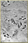
Fig. 13 View of the valley and its environs in 1973.
Note the incipient development of the town of Ojos
Negros.
|
Significant stakeholders in the valley are the "ejidos,"
which are agricultural and ranching cooperatives established in the 1930s.
The first ejidos in Baja California were
established in the valley of Mexicali. Other ejidos along the coast
and inland followed. Two ejidos operate within the valley's confines:
Real del Castillo and Sierra Juarez. A third ejido,
Real del Castillo Viejo, operates in the environs of El Barbon Wash,
north of the Cerro Portezuelo and, strictly speaking, it lies
outside of the Ojos Negros valley.
The ejido Sierra Juarez comprises Mexican land grants lying mostly east of
the valley, within the Sierra Juarez range.
Significantly, the village of Puerta Trampa, lying within the valley
and to the east of it, belongs to the ejido Sierra Juarez. The
majority of the inhabitants of Puerta Trampa, which comprises
about 200 people, are "ejidatarios" of the ejido Sierra Juarez.
In 1995, Article No. 27 of the Mexican Constitution was modified
to permit the sale of lands belonging to the ejidos to third
parties. This led to the incursion of private
enterprise, which, by either renting or buying prime agricultural
land, intensified the economic activity in the valley. In turn, this
intensification is apparently a major factor in the increased
pressure on the groundwater resource.
At present, the valley's stakeholders are:
- The ejidatarios, members of the ejidos, or agricultural cooperatives,
- The agroindustrial companies, which are renting the land from its legal owners,
- The small private proprietors (landowners),
- The small private renters,
- The permanent and seasonal agricultural workers,
- Other inhabitants of the valley,
primarily engaged on the service side of the economy.
3.3 Economic Setting
Agriculture in the Ojos Negros valley is entirely supported by groundwater.
Surface-water reservoirs are nonexistent, since the
high evaporation rate would probably extract a prohibitive toll.
Reflecting this practice, groundwater development has continued in earnest
through the past 30 years, resulting in a large number of pumps.
For various reasons, only a fraction of these pumps are currently active.
Figures 13 and 14 show aerial photographs of the Ojos Negros
valley in 1973 and 1993, respectively. A comparison of
these photos reveals the expansion
in agricultural development which has taken place in the
valley during the aforementioned 20-yr period.
|
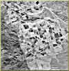
Fig. 14 View of the valley and its environs in 1993.
|
There are four types of crops in the valley:
- Perennial forage, i.e., alfalfa.
- Seasonal forage, which consists of oats, barley, corn, sorghum, and other grasses.
- Grains, including barley, wheat, sorghum, and corn.
- Vegetables, including onions, green onions, and potatoes, and to a lesser extent,
watermelon, melon, garlic, chili peppers, lettuce, squash, radishes,
cilantro, cucumber, cabbage, carrots, and other fruits and
ornamentals.
The crops of the Ojos Negros valley are commercialized in and out of Mexico.
In particular, the entire green onion (cebollin) crop is exported to the United States and Europe.
Ercan (1999) has drawn the
following conclusions from the analysis of crop data:
- The perennial crop (alfalfa) occupies the greatest area
(from 1,305 to 2,024 ha), amounting from more than one-half
of the harvested area, per annual cycle.
- The vegetable crop is predominantly planted in the spring-summer subcycle.
- The productivity of vegetables is high, ranging from 15
to 20 tons ha-1.
- The harvested area of forage is decreasing, while that of grains
and vegetables is increasing. This reflects a gradual shift
from forage to grains and vegetables in the period of analysis (1991-97).
- The crop production of forage is decreasing, while that of grains
and vegetables is increasing. Again, this reflects a
gradual change in emphasis from forage to grains and
vegetables in the period 1991-97.
|
Fig. 15 Cattle raising is an important
economic activity in the valley.
|
For many years, ranching has been one of the principal economic
activities in the Ojos Negros valley. As mining wound down at
the beginning of the century, many immigrants opted to settle
in the area and became ranchers. The valley's climatic
characteristics are conducive to the growth of forage species,
including barley, wheat, and oats, which permitted the development
of substantial ranching activities.
Currently, about 750 persons make their living from animal husbandry
in the valley (Ponce et al., 2000b).
The animal population is represented by
meat-producing cattle (4,604 head), milk-producing cattle (1,862 head),
sheep (310 head), horses (284 head), and pigs (60 head).
The infrastructure includes 95 km of fences, 12 corrals, 5 tick-reducing
baths, and 10 water feeders. Milk production is 11,700
liters per day, with 70 percent of it commercialized as fresh milk, and the
rest (30 percent) is used in the production of cheese.
The meat-producing cattle feed on natural grasses, irrigated prairie,
and crop residues. Up to 1996, there were some feeding lots in
the area, but these have since closed. Cattle are now sent to Mexicali,
Tijuana, and Ensenada for its fattening and subsequent sale.
|

|
Fig. 16 Central plaza at Ojos Negros.
|
|
4. SUPPORTING STUDIES
4.1 Climatology
There is a strong relationship between hydrology, groundwater hydrology,
and climatology. In the Ojos Negros valley in particular,
groundwater exploitation has resulted in a shift of large quantities of
water from the groundwater system to the surface-water
system. This produces an increase in evapotranspiration,
a decrease in the spatially averaged
albedo (Ponce et al., 1997), and a
consequent humidification of the local climate.
In this context, humidification, the reverse process of
desertification, is defined as the gradual and measurable change
in climatic variables and parameters, which results in a more
humid environment.
Ercan (1999)
analyzed the climatological record at Ojos Negros station
to detect trends that may be associated with groundwater
exploitation. The records at El Pinal and Agua Caliente stations were used as control.
Ojos Negros station is located at 31o 54' 42" latitude
and 116o 15' 53''
longitude, at an elevation of 712 m. El Pinal station is
at 32o 11' 00" latitude and
116o 17' 30" longitude,
and at an elevation of 1350 m. Agua Caliente station is
located at 32o 06' 28"
latitude and 116o 27' 14" longitude, and at an elevation of 410 m.
The record length at Ojos Negros is 49 yr, from 1948 to 1996; El
Pinal station has 45 yr of data, from 1949 to 1993; Agua Caliente station
has 27 yr of data, from 1967 to 1993.
The temperature data consisted of daily maximum, minimum, and mean.
For each month, the mean of the daily
maximum temperature was taken as the maximum monthly mean (MaxMMT).
Likewise, for each month, the mean of the daily
minimum temperature was taken as the minimum monthly mean (MinMMT).
After inspection of the entire record, the months
of January and July were selected as the coldest and the warmest,
respectively.
To identify long-term trends in climatic conditions, the range of variation of
seasonal temperature was analyzed.
Backward range (BR) was defined as the difference between the (i)th-yr
July MaxMMT and the (i)th-yr January MinMMT.
Forward range (FR) was defined as the difference between the (i)th-yr
July MaxMMT and the (i+1)th-yr January MinMMT. A
decreasing trend in BR and/or FR depicts humidification, whereas an
increasing trend reflects desertification; that is, arid climates are subject to greater
fluctuations in seasonal
temperature than humid climates.
Ercan (1999)
provided the following conclusions from the climatological study:
- For any station, the difference between backward and forward ranges,
as reflected in the moving average, is almost negligible.
- For all stations, the record shows that there is a finite and
measurable decrease in either range, backward or forward.
- For the Ojos Negros data, the decrease in range is substantial,
amounting to up to 9 oC, as reflected by the moving average of the past 37 yr.
- For the El Pinal data, the decrease in range is moderate,
amounting to up to 6 oC, as reflected by the moving average of the past 35 yr.
- For the Agua Caliente data, the decrease in range is mild,
amounting to up to 4 oC, as reflected by the moving average of the past 21 yr.
The above results indicate that climate change may be happening on
both a local (Ojos Negros) and regional basis (El Pinal and
Agua Caliente), although the reasons for this change, particularly
at the regional level, are not immediately apparent. The data
shows that the postulated climatic changes are more marked at
Ojos Negros. These changes reflect humidification and are
attributed to the anthropogenic effect of shifting water from the groundwater to
the surface-water system. Clearly, statistically significant
changes in temperature are occurring at Ojos Negros, which have the
result of humidifying the environment.
4.2 Remote Sensing
The term "remote sensing" refers to the sensing, measurement, or
detection of specific variables of the Earth's surface, remotely,
i.e., from above, usually from satellite-based sensors or cameras
which operate over a broad range of frequencies of the
electromagnetic spectrum, including the visible range and the infrared.
A vegetation index is obtained by combining multi-band spectral-reflectance
data with the objective of minimizing the
variability due to external effects such as clouds, atmospheric, differences
in solar illumination, and so on. Commonly used
vegetation indices use spectral-reflectance data contained in the red and
near portion of the reflected infrared (near-reflected
infrared). Photosynthetically active vegetative tissue has high absorption
in the red (600-700 nm) and strong reflectance in the
near-reflected infrared (700-1350 nm). Significantly, this spectral
characteristic is not shared by soil and water, the other two
predominant landscape features. Therefore, vegetation indices developed
from spectral data in these two bands have a high
correlation with common vegetative-stand parameters such as leaf-area index,
chlorophyll content, fresh-and-dry
above-ground phytomass, stand height, percent ground cover by vegetation,
plant population, and grain or forage yield.
A widely used vegetation index in agroclimatological studies is the
Normalized-Difference Vegetation Index, or NDVI. This
index enhances the contrast between vegetation and soil/rock, while
compensating for differences in solar illumination.
Values of NDVI range from +1 to -1. When r3 = 0
(zero reflectance in the red),
NDVI = 1, which depicts a very healthy stand of
vegetation, not subject to water deficiency. Conversely, when r4 = 0
(zero reflectance in the near-reflected infrared), NDVI = -1,
which depicts nonvegetative landscape features such as water and snow.
When NDVI = 0, reflection in the red and near-reflected
infrared are exactly the same. Sabins (1997)
has calculated a negative value (-0.26) for a site with dry soil,
and a positive value (0.76) for a vegetated site.
Significantly, NDVI decreases with water stress in a vegetation stand.
As the availability of moisture decreases, either spatially
(due to geographic climatic variability) or temporally (due to drought stress),
actual evapotranspiration rates replace potential
evapotranspiration rates. This leads to a reduction in photosynthetic
activity, to increasing reflectance in the red and, therefore, to
a decrease in NDVI. As water stress increases, NDVI typically decreases
from 0.9 to 0.1.
Ercan (1999)
analyzed two Landsat TM5 satellite images using proprietary image-processing
software.
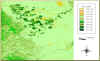
Figures 17 and 18 show NDVI maps of the Ojos Negros valley for
15 April 1993 and 16 May 1996, respectively. Several
hues of green and brown were chosen to mimic natural conditions:
green for vegetation, brown for soil and rock. Green
corresponds to positive values and brown to negative values.

|
Fig. 17 NDVI image for 15 April 1993.
|
The year 1993 was a particularly wet year, judging from the precipitation data.
The precipitation in the
three-month period January-March 1993 totaled 406 mm, substantially above
the annual mean. While there is no data for the
year 1996, because the Ojos Negros Station was discontinued
after 1995, local accounts confirm that 1996 was not a
particularly wet year.
|
Fig. 18 NDVI image for 16 May 1996.
|
Examination of Figs. 17 and 18, confirmed with field observations,
enables the following conclusions:
- The NDVI of irrigated crops is in the range from 0.38 to 0.80,
depending on the type of crop.
- The NDVI of Mediterranean broad-sclerophyll vegetation
(chaparral and related communities) is in the range from
0.12 to 0.38, depending on water stress. There is more
water stress in the 1996 than in the 1993 map, confirming that
1993 was a wet year.
- The NDVI of fallow agricultural land is in the range from 0 to 0.12.
Likewise, the NDVI of riparian areas, which are
located in the northeastern edge of the valley, immediately
south of El Barbon Wash, is 0 to 0.12.
- 4.The NDVI of dry soil is in the range from 0 to -0.13. Likewise,
the NDVI of the channel bed of El Barbon Wash,
consisting of dry medium sand, is 0 to -0.13.
- The NDVI of wetland areas varies from -0.13 to -0.26.
Limited areas of wetland are located in the northwestern edge
of the valley, immediately west of Cerro Portezuelo,
in the vicinity of where the Ojos Negros basin drains into El
Barbon Wash.
4.3 Biotic Communities
The riparian areas of the Ojos Negros valley are located about the northeastern edge,
immediately east of Cerro Portezuelo, in the
proximity of El Barbon Wash, overlying the surface-subsurface connection between the
latter and the Ojos Negros aquifer. The
riparian habitat draws its water needs from the shallow water table at this location.
These associations are related to the riparian
communities of El Barbon Wash, which flank it as soon as it makes its entrance to the
valley, all the way to the basin's mouth, 18
km downstream.
|
Fig. 19 Riparian vegetation on the flood plain
of El Barbon Wash.
|
The first riparian associations, to the east of the transect comprising El Barbon Wash,
include Populus fremonti (alamo), Salix bonplandiana (sauce),
Quercus agrifolia (encino), and Baccharis glutinosa (romerillo).
The adjoining vegetation is chamise chaparral
(Adenostoma fascicultatum) (chaparral de chamiso),
associated to Juniperus californica (huata).
This riparian habitat is subject to intermittent surface water.
A second association encompasses the flood plain of El Barbon Wash and its connection
to the Ojos Negros valley, including
riparian species such as Baccharis glutinosa, Salix bonplandiana,
and isolated stands of Populus fremonti.
This riparian habitat is not
subject to surface water, except during infrequent flood events.
A third association is located in the northwestern edge of study area,
at the basin's mouth.
The predominant vegetation is represented by Adenostoma fascicultatum,
and the riparian vegetation
by Populus fremonti, Quercus agrifolia, Baccharis glutinosa,
and Atemisia tridentata.
Several grasses, including Bromus sp.
and Eragrostis spicata are located within the wash itself.
This riparian habitat is subject to intermittent surface water.
The wetland areas, located northwest of the valley, immediately west of Cerro Portezuelo,
feature hygrophyte species as Juncus sp.,
Typha dominguensis, and Anemopsis californica.
The riparian habitats provide a transition between lotic and terrestrial
ecosystems.
They filter out sediments, particularly sand
particles, which would otherwise be transported out of the immediate vicinity of the
stream or river, and move into agricultural
areas. They also decrease the albedo, in addition to providing food and shelter for
several species of vertebrates.
The fauna of the Ojos Negros valley can be divided into two groups
(Ponce et al., 2000a.):
(1) those that inhabit riparian
areas and wetlands, and (2) those that inhabit the terrestrial ecosystem.
In the first group,
there is an ample variety of migratory and resident birds, among which are ducks,
American coot (Fulica americana),
cattel egret (Bubulcus ibis) and wild bees (Apis sp.).
In the second group, the typical animals are the
squirrels (Spermophilus beecheyi),
rabbits (Sylviagus audobonii), hares (Lepus californicus),
rats (Rattus norvegicus),
larger mammals like the deer (Odocoileus hemionus fulginata),
predators like the puma
(Puma concolor californicus), coyote (Canis latrans),
mountain cat (Lynx rufus),
and fox (Urocyon cinereoargenteus).

|
Fig. 20 Rabbits in the flood plain of El Barbon Wash.
|
Some of the more commons birds are the
partridge (Calliplepla californica),
white-winged dove (Zenaida asiatica),
huilota (Zenaida Macroura),
white owl (Tito alba),
falcon (Falco sp.), and
roadrunner (Geocoxis californicus).
Among the most representative
reptiles are the small lizzard (Sceleophorus occidentalis) and the
rattlesnake (Crotalus ruber).
4.4 Agricultural Economics
The Ojos Negros valley consists of approximately 100 km2 of aluvial terrain,
of which about
30% is intensively farmed by irrigation systems which have been developed
over the past
three decades. The water for irrigation is obtained exclusively from the
pumping of groundwater. The Comision Nacional del Agua (1997) has estimated that the annual yield exceeds the
annual recharge by about 6.5 hm3.
This difference has resulted in the gradual
lowering of the water table, which at one time (c. 1960) was close to the
surface, but now lies
at depths of more than 30 m toward the center of the aquifer.
The cost of pumping is proportional to its depth; therefore, it is necessary to evaluate the
effect that the increasing cost of pumping can have on the
agricultural enterprise. To this end, an agricultural database
is developed, to be integrated later with a hydrogeologic model. The
objective is to determine the effect of the cost of pumping on the profits derived from
the agricultural enterpise.
The history of the Ojos Negros valley goes back to 1870, when the discovery
of gold in the region caused the settlement of many newcomers from other regions of
Mexico and the United States.
Around the turn of the twentieth century, livestock
raising followed mining as the most important economic activity and, after
1970, irrigated agriculture started to develop in earnest.
Irrigated agriculture is currently the most important economic activity in
the valley,
with 3099 ha operated with sprinkler, drip, and central pivot systems.

|
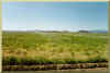
Fig. 21 Agricultural fields in the Ojos Negros valley.
|
The predominant crops are forage and vegetables. Forage consists of alfalfa, barley, maize,and oats;
the main vegetables are green onion, watermelon, cilantro, onion, and radishes.
In the past six
years, there has been a tendency for the replacement of forage for
vegetables; the latter constitute now more than 53% of the irrigated area.
Apparently, this
tendency is due to the fact that vegetables use less water and, therefore,
less energy, than
forage. Moreover, the vegetables are irrigated with water-conserving drip systems,
while the forage is irrigated with conventional sprinkler systems.
Another tendency of the last few years is the gradual change in the relative
importance of the local actors.
Prior to this change, the members of Ejido Real
Del Castillo were the only local actors. (An ejido is a Mexican agricultural cooperative,
established by the law of 1938;
its members are referred to as ejidatarios).
Nowadays,
changes in the law (beginning in 1994)
and transborder dynamics
encouraged by the North American Free Trade Agreement
(NAFTA) have led to the existence of the following four actors:
- Ejido proprietors, or ejidatarios,
- Other individual proprietors,
- Renting agroindustrial companies, and
- Other individual renters.
Although the ejidatarios which personally operate the ranchos (an ejido property) are still
in the majority, the current tendency is for the increase in the number of
renters, both agroindustrial companies and individual renters. Particularly in the last two
years (1998-2000), the
presence of agroindustrial companies of mixed U.S.-Mexican capital has been markedly felt,
with an increase in total investment and associated increase in the economic
activities.
Prior to the advent of irrigation, the water table was close to the surface to the west
of the valley,
following the course of Ojos Negros Creek, which drains
the valley (Ponce et al., 1999).
This made possible the existence of wetlands and riparian
areas and sustained the natural vegetation of the interfluves (chaparral
vegetation). According to the map dating back to 1864
(Fig. 30),
the marshes were very extensive.
The mouth of Ojos Negros Creek was actually the site of a large marsh, rivaling in length that of
neighboring Cerro Portezuelo.
This marsh still exists today, but it has been reduced to a small fraction of what is used to be
more than 100 years ago.
The two oval-shaped marshes to the southwest,
which gave its name to the Ojos Negros valley, have all but disappeared.
With irrigation, the water table has been depleted well below the root zone, the
wetlands, marshes, and riparian areas have been reduced to a minimum,
and the natural vegetation has been replaced by the artificial vegetation typical of intensive agriculture.
The landscape is no longer pristine; however, substantial economic benefits have accrued from this change.
The methodology for the agroeconomic study consisted of the following steps:
- Formulation of the agroeconomic spreadsheet
The spreadsheet consisted of the following column data: user, plot number, total area (ha),
number of pumps, ownership, type of crop, irrigation system, cultivated area (ha/yr), unit
crop yield (kg/ha), annual yield (kg/yr), unit water
consumption (m3/ha),
aquifer yield (m3/yr), unit
water cost ($/m3/m),
pumping depth (m), water cost ($/m3),
total water cost
($/yr), materials ($/yr), salaries ($/yr), rent ($/yr), total production cost ($/yr), unit crop
price ($/kg), gross production ($/yr), subsidy ($/yr), total gross production (gross
production plus subsidy) ($/yr), net production ($/yr), efficiency (net production/gross
production) (%), capital ($), and profit margin (net production/capital) (%).
- Data collection with Mexican federal agencies (SAGAR, CNA, CFE)
The following data for relevant crops were obtained from the Agriculture Ministry
(SAGAR): (1) unit water consumption (m3/ha), (2) unit salaries ($/ha),
and (3) unit crop
price ($/kg). The following data were obtained from the federal water agency (CNA): (1)
hydrogeologic data such as well and pump type, quantity, pumping schedule and yield,
and (2) depth to the water table. Energy bills for each plot and user, for the period 1996-99,
were obtained from the federal energy agency (CFE).
- Interviews with local actors
The local actors were interviewed during the months of June and July 2000 with the
objective of gathering first-hand information on the agricultural operations. The following
interviews were made: 30 ejido proprietors, 2 individual proprietors, 4 company renters,
and 7 individual renters, for a total of 43 interviews. The interviews were limited to plots
of the Ejidos Real del Castillo and Sierra Juarez which pump the Ojos Negros aquifer, south of Cerro Portezuelo.
- Spreadsheet calculations
The data obtained from CFE (cost of electricity), CNA (depth of pumping), and SAGAR
(crop water demand) were analyzed with the objective of estimating the mean unit cost of
pumping, which was determined to be 0.01 Mexican pesos/m3/m, equivalent
to U.S. $ 0.0011.
4.5 Environmental Impacts and Social Attitudes
Pineda Villa (2000) has recently studied environmental impacts and related
social attitudes regarding the sustainable use of water in the Ojos Negros valley.
He studied physical, natural, and social components, including photointerpretation,
and classified the Ojos Negros valley into seven environmental units:
- Agricultural
- Animal husbandry
- Cerro Doña Eulalia
- Cerro Portezuelo
- Wetland
- Sloping
- Populated
To assess the extent of the land-use changes since the advent of irrigated agriculture in the valley,
Pineda Villa (2000) used the images shown in Fig. 13
(1973) and Fig. 14 (1993). Table 2 shows
the change in land use between 1973 and 1993.
Table 1. Change in land use in Ojos Negros valley
between 1973 and 1993 (Pineda Villa, 2000). |
| Type of land use | 1973 (%) | 1993 (%) |
| Agricultural & Animal Husbandry | 61.71 | 64.75 |
| Cerro Doña Eulalia | 1.88 | 0.56 |
| Cerro Portezuelo | 2.23 | 2.19 |
| Wetland | 0.11 | 0.04 |
| Sloping | 33.72 | 31.80 |
| Populated | 0.35 | 0.66 |
| Total | 100.00 | 100.00 |
Pineda Villa (2000) interviewed sixteen (16) stakeholders in the Ojos Negros valley with aim of
determining social attitudes regarding the sustainable use of water. The sample of people
interviewed included farmers, ranchers, townspeople, salaried workers,
indigenous peoples, and local authorities. Seven of those interviewed were more than 50 years old, while
59% were born in either Ojos Negros or Baja California. Pineda Villa (2000) identified the following
impacts of irrigated agriculture:
- Groundwater depletion and associated loss of wetlands and riparian areas.
- Soil erosion and soil compaction, due to
overgrazing and poor farming practices.
- Increase in dust, odors, and noise.
- Humidification of the ambient air due to
increased evapotranspiration of irrigated lands.
- Fragmentation of the landscape and decrease of natural vegetative ecosystems.
- Positive social impacts due to increased economic activities.
Pineda Villa (2002) reached the following
conclusions regarding the Ojos Negros valley:
- There a need for a conservation program to keep
the wetlands, sloping lands, and Cerro Portezuelo from further encroachment by economic forces.
- The population of Ojos Negros is not fully conscious of the value of water
in their lives.
- There are no more natural areas for agricultural expansion, and the
remaining wetlands need to be protected against encroachment.
- There is an active participation of stakeholders, with sufficient
knowledge of the actions that are needed to conserve the health's of the valley's modified ecosystem.
- The policies outlined in the "Program for Ecological Ordering of the
Territory" (Programa de Ordenamiento Ecológico del Territorio) regarding specific goals
for the Ojos Negros valley (regulation) are not being followed. The general policy is "development,"
and the specific policy is "regulation." The latter has yet to be implemented in the valley.
4.6 Sociological Aspects
The Ojos Negros valley is a rural area comprising several social actors which are directly or indirectly
tied to agriculture and animal husbandry. These are primarily local actors;
there are some other actors which are individuals, organizations, companies, or institutions that originate
within the confines of the municipality (Ensenada),
or elsewhere in Baja California, Mexico, and other countries.
The ejidatarios are the group with greater presence and influence in the valley's
economic and social development. This group gets involved in agriculture and animal husbandry.
There are also a few individual proprietors, although as a group there are not as important as the ejidatiarios.
An extensive social group is constituted by the migrant agricultural workers. Those of Indian ethnicity originate
in the states of Oaxaca, Chiapas, and Michoacan; those of non-indian background originate in the states of
Zacatecas and Durango, among others. A few local indigenous peoples live in the community of La Huerta,
east of the Ojos Negros valley.
The difference between the newly arrived indians (migrant workers) and those who reside on the region for generations
(local indigenous)
lies on their type of work. Those newly arrived are employed in the sowing and harvesting, and in the
packing industry, and their activities
are intensive, specialized, and rather monotonous. Conversely, the local indians
are mostly employed as cowboys in the ranches and do not engage in monotonous activities.
The significant presence of foreign-owned or partially-foreign-owned companies is a phenomenon which underscores the agricultural
importance of the Ojos Negros valley. These companies rent the land from the ejidatarios
or individual proprietors and work them with modern tecnologies to generate agricultural products destined
for the overseas markets (the United States and England).
Another social group is formed by those that work in service-related jobs, such
as commerce, teaching, and government.
The Ojos Negros valley is intrinsically tied to the city of Ensenada, and its economic life
is ruled in large measure by actors, of the productive and government sectors, who reside permanently
in Ensenada. There is a group of ejidatarios who do not reside in the valley, but who engage in
productive activities therein. These are "urban-rural" productive actors," who own ranches producing milk, vegetables,
or other agricultural products, but who live permanently in Ensenada.
There are also "governmental actors" who exert a considerable influence in the region.
At the municipal level, the Delegate is the official authority with regard to public safety,
municipal, and other services. The state government exerts influence through the Secretary of Social Development
(Secretaría de Desarrollo Social) and Secretary of Agricultural Support (Secretaría de Fomento Agropecuario).
The first one supports social and community projects such as sporting fields, public lighting, educational and health
facilities; the second one provides economic, logistic, and technical support to the productive actors.
The federal government participates in the valley's life through the Comisión Nacional del Agua, and the
Secretaría de Agricultura, Ganadería, Desarrollo Rural, Pesca y Alimentación (SAGARPA).
The Instituto Nacional de Investigaciones Agrícolas, Forestales, y Pecuarias (INIFAP),
a unit of SAGARPA, with offices in Ensenada, operates an experiment station in the Ojos Negros
valley.
4.7 Water Law and Administrative Politics
The Ojos Negros valley is subject to municipal, state, and federal laws regarding water resources.
The Constitution of the Mexican United States, in its Article 27 says the following (Ponce et al, 2000):
"...The property of the lands and waters comprised within the limits of the
national territory correspond in its origin to the nation..."
The Application of the Law of National Waters, in its Article 2, Fraction X, defines sustainable
development as follows:
"...The management of natural resources and the orientation of technological
and institutional change, so that it will assure the continuous satisfaction of human needs for the
benefit of present and future generations..."
The General Law of Ecological Equilibrium and Environmental Protection (Ley General del Equilibrio
Ecológico y Protección del Ambiente), in its Article 88, stipulates that it corresponds
to the state and society the protection of aquatic ecosystems and of the equilibrium
of the natural elements that form part of the hydrologic cycle.
The Ojos Negros valley is part of the Delegation of Real del Castillo,
municipality of Ensenada,
state of Baja California. The Municipal Delegate, named by the Mayor of Ensenada,
is the head of the office of the delegation at Ojos Negros. The Municipal Delegate is in charge of
general governance, police and traffic, financial affairs, public services, agriculture
and animal husbandry, water resources, public works, health, education, environmental protection,
and justice (Ponce et al., 2000).
|
|
Fig. 22 Sprinkler irrigation in the valley.
|
|
5. MODELING
5.1 Groundwater Model
The Ojos Negros valley is being subjected to groundwater depletion (Comisión Nacional del Agua, 1997).
Therefore, groundwater modeling is required to simulate
the long-term behavior of the aquifer under postulated management policies.
The modeling exercise is important because it may
be the only way of quantitatively assessing the effect of regulatory policies
vis-à-vis exploitative practices.
Groundwater modeling seeks to calculate the short- and long-term temporal and
spatial variation of the piezometric head of an
aquifer, when the hydrogeologic characteristics, initial, and boundary conditions
are known or can be reasonably estimated.
The modeling requires a choice of number of spatial dimensions,
a governing differential equation to match
this choice and appropriate initial and boundary conditions.
The choice of spatial dimensions depends on the problem at hand.
Given the shape and geometric characteristics of
the aquifer, the additional accuracy to be gained by three-dimensional modeling is not warranted.
Furthermore, the quality of the available data
does not justify three-dimensional modeling. Thus, two-dimensional
modeling is chosen as the preferred strategy for the Ojos Negros aquifer.
Groundwater flow is essentially a diffusion process; therefore, any numerical
scheme that solves the two-dimensional diffusion
equation with good stability and convergence properties is appropriate.
It is well known that explicit schemes are simple but
that they are conditionally stable; on the other hand, implicit schemes are
complex but unconditionally stable.
Lesser known is the fact that convergence considerations effectively place an upper limit on
the time interval that can be used in practice with an implicit scheme.
Moreover, convergence also places a lower limit on the
time interval that can be used with an explicit scheme. Given these constraints,
there does not appear to be a definite advantage of implicit over explicit schemes.
A groundwater model suitable for application to the Ojos Negros valley
was developed in this study.
The numerical model is an explicit
finite-difference formulation of the two-dimensional diffusion equation of
flow in porous media. Sources
(percolation from rainfall and/or irrigation) and sinks (pumping) are accounted
for as specific terms of the diffusion equation.
There are six types of boundary conditions:
- Dirichlet Type A, which specifies a finite value of the head.
- Dirichlet Type B, which specifies a zero value of the head.
- Neumann Type A, which specifies a finite value of the flux, i.e.,
of the gradient orthogonal to the boundary (permeable boundary).
- Neumann Type B, which specifies a zero value of the flux, i.e.,
of the gradient orthogonal to the boundary (impermeable boundary).
- Mixed Neumann Type A and Type B, which simulates a semipermeable boundary.
- Mixed Dirichlet-Neumann boundary condition,
which specifies a linear combination of head and flux at the boundary.
The mathematical formulation of the two-dimensional groundwater flow model
used in this study has been presented by Ercan (1999).
To satisfy both stability and convergence, the cell Reynolds number was set at 1.
(Values of cell Reynolds number greater than 1 were unstable, while values less than 1
were nonconvergent).
This led to a finite-difference equation
in which the piezometric head at the unknown node (j, k, n+1),
is based on the average piezometric head at the four known nodes adjacent to (j, k, n),
the percolation rate r(j, k), the pumping rate p(j,k), the grid
interval, the time interval, and the storativity.
The simulation marches in time by first calculating the unknown heads at all interior node points.
Dirichlet Type A boundary conditions are specified by a prescribed finite value of head at the boundary nodes.
Neumann Type A boundaries are specified by
linear extrapolation from the two immediately neighboring interior nodes.
Neumann type B boundary conditions are specified by relocation of the neighboring interior node
(impermeable boundary).
A 100-m square grid is superimposed over the aerial extent of the aquifer.
To satisfy spatial resolution requirements, the square-grid area (1 ha)
should be a very small fraction of the aerial extent of the model(9600 ha).
The computational model is written in C++
programming language to enable linking with GIS.
Input/output is
expressed in a general raster-data format to provide compatibility
with GIS. The results of the simulation can be
directly read, analyzed, overlaid, and manipulated
in real-world spatial coordinates.
5.2 Model Integration with GIS
The data to operate the groundwater model was obtained from Comisión Nacional del Agua (1997).
The digitized piezometric contours corresponding to November 1995 and February 1997 were used to
create a continuous surface
to define a grid-data format for the Arcview software.
This data was overlaid with the Ojos Negros parcel and pump location data (Fig. 23).
The estimated water consumption for each parcel,
obtained from the agroeconomic study, was used as a baseline condition for the GIS-driven
groundwater model.
Using the Avenue scripting language, a special menu system was programmed in Arcview.
This allowed the groundwater model to run within the GIS,
enabling the simulation of groundwater conditions.
|
Fig. 23 Parcel and pump location data
used in the
groundwater model.
|
The February 1997 piezometric data was used as initial condition for the simulation runs.
After appropriate calibration and testing, the boundary conditions were set as follows:
- Neumann Type A, with weighting factor a = 1, i.e., a permeable boundary.
- Mixed Dirichlet-Neumann, with weighting factor w = 0.001, i.e., a small
allowance for a Neumann boundary (flux-specified).
Five simulation runs were made at t = 5, 10, 20, 30, and 50 yr, enabling the calculation of
the water table for these planning horizons. The results are shown in Fig. 24. This set of
figures show a gradual decrease in the water table,
with an average of about 20 m throughout the model area. This represents an average depletion
of 0.4 m/yr, which compares favorably with the data measured by Comisión Nacional
del Agua (1997) (0.32 m/yr).

|
Fig. 24 Results of the GIS groundwater model simulation.
|
The results of the groundwater simulation were interfaced with the agroeconomic spreadsheet in order to
evaluate the effect of groundwater depletion on the profits from the agricultural operations.
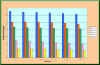
Figures 25 and 26 show simulated profits for selected ejido propietors and agroindustrial
companies, respectively, as a function of time,
with postulated groundwater depletion as calculated by the groundwater model.
|
Fig. 25 Projected profits from ejido proprietors
in
the Ojos Negros valley.
|
The effect on the profits of ejido proprietors is marked, although not large.
The effect of the profits of agroindustrial companies in small. This is attributed
to the relatively small unit cost of water, which has been estimated in Section 4.4
as (Mexican pesos) $ 0.01 to raise 1 cubic meter the vertical distance of 1 meter.
Assuming a mean depth of pumping of 30 m, this results in
(Mexican pesos) $ 0.30 per m3
water cost for the
average user, or U.S. $ 0.033 per m3 (assuming 1 U.S. dollar = 9
Mexican pesos).
By way of comparison, the cost of California
surface water (State Water Project) is estimated at U.S. $ 250 per ac-ft,
which amounts to $ 0.202 per m3,
which is more than six times the cost of water in the Ojos Negros valley.
This implies that the cost to pump Ojos Negros aquifer water is very small compared
to other sources.
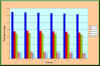
|
Fig. 26 Projected profits from agroindustrial
companies
in the Ojos Negros valley.
|
5.3 Electric Tariffs
The depletion of the groundwater table appears to be related to the cost of the electricity.
The lower the electricity cost per kwh,
the greater the incentive to users to pump groundwater and contribute to the depletion of the water table.
Table 2 below shows electric tariffs for the month of August 2001, taken from the website of the
Comisión Federal de Electricidad
(http://www.cfe.gob.mx). This table shows conclusively that
electricity rates in the region are lowest for agricultural groundwater pumping, a decision
apparently related to society's perceived need
to support irrigated agriculture.
| Table 2. Electric tariffs for the month of August 2001,
taken from CFE's website. |
Tariff
No. | Type of service | Cost per kwh
(Mexican pesos) | Limitation
(kwh) | Minimum charge
(Mexican pesos) |
| 1 | Domestic | $ 0.454 | 0-75 | $ 11.35 |
| 1 | Domestic | $ 0.536 | 76-200 | $ 11.35 |
| 1 | Domestic | $ 1.568 | more than 200 | $ 11.35 |
| 5 | Public (street lights) - medium voltage |
$ 1.289 | none | 4 hours |
| 5 | Public (street lights) - low voltage |
$ 1.534 | none | 4 hours |
| 6 | Public (pumping of water or sewage) |
$ 0.803 | none |
$ 145.25 |
| 7 | Temporal (any other use) | $ 1.945 |
none | none |
| 9 | Agricultural (groundwater pumping) - low voltage |
$ 0.247 | 0-5000 | none |
| 9 | Agricultural (groundwater pumping) - low voltage |
$ 0.300 | 5001-10000 | none |
| 9 | Agricultural (groundwater pumping) - low voltage |
$ 0.332 | 10001-20000 | none |
| 9 | Agricultural (groundwater pumping) - low voltage |
$ 0.366 | more than 20000 | none |
| 9M | Agricultural (groundwater pumping) - medium voltage |
$ 0.249 | 0-5000 | none |
| 9M | Agricultural (groundwater pumping) - medium voltage |
$ 0.304 | 5001-10000 | none |
| 9M | Agricultural (groundwater pumping) - medium voltage |
$ 0.335 | 10001-20000 | none |
| 9M | Agricultural (groundwater pumping) - medium voltage |
$ 0.369 | more than 20000 | none |
In the absence of effective aquifer regulation,
and as long as electric tariffs remain the lowest for groundwater pumping,
it is reasonable to expect that water table depletion will continue unabated.
This conclusion is supported by detailed agroeconomic and hydrogeologic studies which show that
current water table depletion levels (averaging
more than 30 m in some places)
do not substantially affect the economies of the principal actors or stakeholders. A few stakeholders,
typically the less efficient ejido proprietors,
will be affected, but it is likely that most actors, particularly the agroindustrial companies,
can and will continue to operate into the future.
5.4 Assessing Sustainable Management
The sustainable management of groundwater in the Ojos Negros valley is a
complex interdisciplinary task. Issues of climatology, soil science, hydrology,
hydrogeology, agricultural economics, sociology, and border dynamics, besides institutional,
political and other
constraints, are intertwined into a complex web of relations dating back more than 30 years.
Hydrogeologic modeling can serve as the basis for the initial assessment, but sound policy decisions
will have to be based on the broader and delicate issue on how to balance economic growth
with ecological and social sustainability.
The protracted depletion of the Ojos Negros aquifer has been thoroughly
documented, and this analysis shows that under the present circumstances it is likely to
continue for some time.
The demonstrated tendency to a shift to more water-conserving crops may postpone the problem
but will not eliminate it.
It is seen that the Ojos Negros valley is being faced with the classical "Tragedy of the Commons"
(Hardin, 1968).
According to this well known principle, in the absence of regulation,
resources held in common (i.e., the commons)
will tend to be overexploited, since the unitary benefit accruing to an individual stakeholder
translates only as a fractional loss to other stakeholders in the community.
For an individual stakeholder to place the common interest above his/her own will not work,
since there is no guarantee that all other stakeholders will follow suit. To put it in
Hardin's own words:
Picture a pasture open to all.
It is to be expected that each herdsman will try to keep as many cattle as possible on the commons...
As a rational being, each herdsman seeks to maximize his gain. Explicitly or implicitly,
more or less consciously, he asks, "What is the utility to me of adding one more animal to my herd?" This utility has one
negative and one positive component.
- The positive component is a function of the increment of one animal. Since the herdsman
receives all the proceeds from the sale of the additional animal, the positive utility is nearly +1.
- The negative component is a function of the additional overgrazing created by one more animal.
Since, however, the effects of overgrazing are shared by all the herdsmen, the negative utility for any
particular decision-making herdsman is only a fraction of -1.
Adding together the component partial utilities, the rational herdsman concludes that the only
sensible course for him to pursue is to add another animal to his herd. And another... But this is the conclusion
reached by each and every rational herdsman sharing a commons. Therein is the tragedy. Each man is
locked into a system that compels him to increase his herd without limit -- in a world that is limited.
Ruin is the destination toward which all men rush, each pursuing his own best interest in a society that
believes in the freedom of the commons. Freedom in a commons brings ruin to all.
Thus, aquifer regulation appears to be the only way out of this predicament.
Regulation should go hand-in-hand with monitoring, since sound policy should always be
based on sound data. Without regulation, there is no effective means of guaranteeing the sustainability
of the groundwater resource. With regulation, there is an increased chance that the resource will be there
for the benefit of future generations.
|
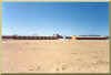
|
Fig. 27 Housing for seasonal workers
at Rancho Valladolid.
|
|
6. CONCLUSIONS AND RECOMMENDATIONS
6.1 Summary
An interdisciplinary study of the
Ojos Negros valley, in
Baja California,
with specific focus on the exploitation of groundwater and the climatological, ecological, economic, and social
impacts thereof, has been accomplished.
The study seeks to lay the groundwork for the sustainable management
of water in the valley, located about
80 km south
of the U.S.-Mexico border.
The importance of the valley as a regional economic
resource, with significant transborder effects, is widely recognized.
The study has documented various aspects of the geological, geomorphological,
climatological, pedological, biological,
hydrological, hydrogeological, ecological, economic, agricultural,
animal husbandry, historical, sociological,
institutional, and political setting of the Ojos Negros valley, with specific
emphasis on the groundwater resource and the issue of its ecological sustainability.
The Ojos Negros aquifer is bowl-shaped and entirely contained
in a graben lying within the confines of El Barbon basin.
Detailed analysis of the climatological record, particularly the 10-yr
moving average trend in temperature range,
revealed a pattern of climatic change toward a more humid environment.
In the case of the Ojos Negros valley, this change is attributed to anthropogenic
effects, i.e., humidification resulting from increases in actual evapotranspiration
which can be linked to the groundwater-supported agricultural expansion of the last three decades.
A model of the Ojos Negros aquifer was formulated, developed, tested, calibrated, and
applied using relevant data.
The numerical scheme is an explicit finite-difference formulation of the
two-dimensional diffusion equation of flow in porous media,
with source/sinks considered. A specific feature of the model is
the requirement that it operate exactly at cell Reynolds number
equal to 1 in order to satisfy stability and convergence requirements.
The program was written in C++ and the model
was linked to GIS software (Arcview).
Results of the simulation showed the effect of groundwater depletion
on the profits from agricultural operations.
This effect was more marked for the profit of the ejido proprietors,
and less marked for the profit of the agroindustrial companies. The apparent lack of
sensitivity is attributed to the low cost of energy, since the electric tariffs
for agricultural groundwater pumping are the lowest (see Table 2, Section 5.3).
This practice results in a low cost of groundwater pumping in the valley, which
is at the root of the problem of aquifer depletion.

|
Fig. 28 A dead poplar, or alamo (Populus fremontii),
relic of a vanished
wetland, at Rancho Ojos Negros, in the Ojos Negros valley.
|
6.2 Conclusions
The following conclusions are drawn from this study:
- The Ojos Negros valley and its underlying aquifer sustain a complex web
of interdisciplinary relations; from geology to transborder economics; from sustainable
management to politics.
This report has documented these relations with the aim of finding a cause of the protracted
groundwater depletion
which has been occurring in the valley for the past three decades.
Climatological, hydrogeological, ecological, economic, and institutional dynamics have been assessed
using modern analytical techniques.
- The marked decreases in temperature range
(9oC) in the Ojos Negros valley in the past 37 yr
are attributed to humidification resulting from intensive irrigation.
Irrigated agriculture has the effect of increasing actual evapotranspiration and, consequently, humidifying
the local climate. The effects of humidification will continue as long as groundwater
pumping continues,
with large amounts of subsurface water being transferred to the surface water system.
The effect is anthropogenic; therefore,
it is expected to disappear in the unlikely event that pumping were to be discontinued.
-
Historical evidence suggests that the marshes, wetlands, and riparian areas in the Ojos Negros valley
and its environs were more extensive in the past. Significantly, the Ojos Negros marshes,
which gave its present name to the valley,
have all but disappeared due to protracted groundwater depletion. The once-extensive marsh
located immediately west of Cerro Portezuelo (see
Fig. 30)
appears to have diminished substantially in size since the 1864 map (or sketch) documenting
its aerial extent.
Local accounts
confirm that the effect of groundwater depletion has been a progressive drying of the
existing marshes and wetlands.
This has certainly affected vegetative biodiversity
and may have also impaired regional flyways. On the other hand, the development of
irrigated agriculture has made possible
an active if not vibrant local economy, of which some of its products are clearly destined
for export.
-
Average water table depletion was forecasted to be 0.4 m yr-1
for the 50-yr planning horizon,
assuming present pumping rates (year 2000).
This rate of depletion has an effect on the profits of agricultural operations,
but the effect does not appear to be substantial.
In the absence of appropriate regulation, it is likely that
stakeholders will continue to operate their agricultural enterprises.
A few stakeholders, typically the less efficient,
will be negatively affected, but most,
particularly the agroindustrial companies, will continue to operate into the future.
-
It is certain that the groundwater depletion at Ojos Negros is related to the classical
"Tragedy of the Commons."
According to this principle, resources held in common will tend to be overexploited by
individuals seeking their own gain.
Viewed in this light, aquifer regulation appears to be the only way out of this predicament.
Regulation should go hand-in-hand with monitoring, since sound policy should always be
based on sound data. Without regulation, there is no effective means of guaranteeing the sustainability
of the groundwater resource. With regulation, there is an increased chance that the resource
will still be there
for the benefit of future generations.
6.3 Recommendations
The following recommendations are offered for specific action:
- The Ojos Negros climatological station has been discontinued
as of 1996. Currently there is no way of supporting hydrological conclusions on field data.
Efforts should be made to recommission the
Ojos Negros station so that high-quality climatological
data can support continuing resource studies.
- A policy aimed at aquifer regulation should be developed and implemented
in the Ojos Negros valley. Such policy should account for the views and perceptions of local
stakeholders. At a minimum, the policy should seek to establish either a sustainable volume of
water to be pumped
every year, or a maximum water table depletion (minimum water table elevation) to be allowed at
several representative aquifer locations.
These values should be based on detailed hydrogeologic studies.
Established water rights should be taken into account when developing the policy.
- Groundwater depletion is a pervasive problem in the Californias on
both sides of the border.
The effective cooperation
of local stakeholders, government officials at all levels of government,
professionals, university scientists, and concerned citizens is needed to learn
from the Ojos Negros and other similar experiences, and to use this experience
in the construction of the difficult path towards resource sustainability.
|
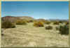
|
Fig. 29 Riparian vegetation in the entrance to the valley.
|
|
7. REFERENCES
Comisión Nacional del Agua. 1997. Actualización Hidrogeológica del Valle Ojos Negros,
Baja California. Ensenada, México. Gerencia Regional de la Península de
Baja California, Subgerencia Técnica Regional.
Ercan, S. 1999. Sustainable management of
water resources in the Ojos Negros Valley,
Baja California, Mexico. Thesis, Civil and Environmental Engineering Department,
San Diego State University, San Diego, California.
Garcia, E. 1981. Modificaciones al Sistema de Clasificacion Climatica
de Koppen. Instituto de Geografia. Mexico, D.F.:
UNAM, 244 pp.
Gray, A. A. Historia de California. D. C. Heath and Co, 1934.
Hardin, G. 1968. The Tragedy of the Commons. Science, 162, 1243-1248.
Martinez, Z. J. 1937. Real del Castillo: 1870-1882. Biblioteca UABC, Ensenada, Mexico.
Meadows, D. 1985. Real del Castillo, Olvidada Capital de Baja California.
Tijuana, Baja California, Coleccion Historia Para
Todos, folleto 2, Centro de Investigaciones UNAM- UABC, 1985.
Minnich, R. A. and E. Franco V., 1998. Land of Chamise and Pines, Historical accounts
and current status of Northern Baja California vegetation. Botany 80, University of
California Press, Berkeley.
Padilla Corona, A. 1999. Real del Castillo: Subprefectura Política del Partido
Norte de la Baja California, 1872-1882.
Capitulo 6 en Ensenada: Nuevas aportaciones para su historia, Universidad Autónoma de
Baja California,
Baja California, México.
Pineda Villa, A. 2000. Cambios ambientales y uso sustentable del agua en el valle de Ojos
Negros, B.C., México.
Tesis, Maestría en Ciencias en Manejo de Ecosistemas en Zonas Aridas, Facultad
de Ciencias,
Universidad Autónoma de Baja California, Unidad Ensenada, Baja California, Agosto,
114 páginas.
Ponce, V. M. Engineering Hydrology,
Principles and Practices.
Englewood Cliffs, NJ: Prentice Hall, 1989.
Ponce, V. M., A. K. Lohani and P. T. Huston.
1997. Surface Albedo and
Water Resources: Hydroclimatological Impact of
Human Activities. Journal of Hydrologic Engineering, 2, 197-202.
Ponce, V. M., R. P. Pandey, S. Kumar.
1999. Groundwater Recharge
by Channel Infiltration in El Barbon Basin, Baja
California, Mexico. Journal of Hydrology, 214, 1-7.
Ponce C., V. M., W. R. Zúñiga C., F. R. Venegas C., T. Gaona A.,
R. O. García C., J. I. Sepúlveda B., and G. Arámburo V. 2000.
Valle de Ojos Negros: Resumen Interdisciplinario.
Part a;
Part b.
San Diego State University, Universidad Autónoma
de Baja California, and Instituto Nacional de Investigaciones Agrícolas,
Forestales, y Pecuarias.
June, 42 pages.
Rouse, J. W., R. H. Haas, J. A. Schell, D. W. Deering, and J. C. Harlan.
Monitoring the Vernal Advancement of
Retrogradation of Natural Vegetation. Greenbelt, MD: NASA/GSFC,
Type III, Final Report, 1974.
Sabins, F. F. 1997. Remote Sensing: Principles and Interpretation.
W. H. Freeman and Company, Third Edition, New York.
Secretaría de Desarrollo Social. 1993. Plan de Acción para Combatir la
Desertificación en México (PACD-México).
Comisión Nacional de las Zonas Aridas, Coahuila, Mexico.
Soil Survey Staff. Keys to Soil Taxonomy. U. S. Department of
Agriculture Soil Conservation Service, Sixth Edition,
1994.
Southworth, L. R. 1899. El territorio de Baja California Ilustrado.
Ensenada, Mexico: Direccion del Gobierno de Baja
California.
Weege, B. C. 1976. Geologic Map and Geologic Interpretation of Ojos
Negros Valley, Baja California. Senior Thesis Project,
San Diego State University, May.
|
|
Fig. 30 Map of the valley of San Rafael dating back to 1864
(Zárate Archives, Ensenada, Baja California).
|
| http://ponce.sdsu.edu/ojos_negros_report_final.html |
030212
|
|