|
IMPACT OF THE PROPOSED CAMPO LANDFILL
ON THE HYDROLOGY OF THE TIERRA DEL SOL WATERSHED
A REFERENCE STUDY
Victor M. Ponce
May 2006
|
EXECUTIVE SUMMARY
The impact that the proposed Campo landfill will have on the hydrology of the Tierra del Sol watershed
is examined using an interdisciplinary perspective.
Analysis of precipitation and well data suggests the presence of
an effective hydraulic connection between surface water and groundwater in the region.
Existing fracture maps and other geologic evidence reveal the extent to which the underlying aquifer is fractured.
The presence of numerous springs and photogeologic lineaments indicates that water flows
readily from the fractured-rock aquifer to the creeks, streams, and wells of the Tierra del Sol watershed.
Selected vegetative species with an established moisture affinity are documented in the Tierra del Sol watershed.
Specimens of blue elderberry (Sambucus mexicana) appear to be aligned along fractures, where moisture
can be sustained for long periods. Thick stands of red shank (Adenostoma sparsifolium) constitute the predominant species
in several of the lineaments identified in aerial images. Unlike the chamise (Adenostoma fasciculatum), its closely related and
more widely distributed chaparral species, the red shank is a tall arborescent shrub which thrives on moist sites.
The spatial distribution of blue elderberry and red shank points to the existence of local moisture gradients
which could be tied to the rock fractures.
In fractured-rock aquifers, a leachate plume will move preferentially along the fractures.
Advection is likely to be the predominant physical mechanism, with travel times from capture zone to nearby wells measured in days,
rather than in years as would be the case in more traditional diffusion-dominated settings.
Given the complexity of the fractured-rock system, the probability that leachate plumes will be missed by the system of monitoring wells is high.
Thus, placing a major landfill on top of a fractured-rock aquifer such as Tierra del Sol's
significantly compromises the health and welfare of the local population on both sides of the U.S.-Mexico border.
Moreover, Tierra del Sol is part of the federally designated Campo-Cottonwood Creek Sole Source Aquifer, i.e.,
it has been determined that, should this aquifer become contaminated,
there are no reasonably available alternative sources of drinking water.
|
1. INTRODUCTION
The impact that the proposed Campo landfill will have on the hydrology of the Tierra del Sol watershed is examined herein.
The Campo landfill site is located within the Campo Indian reservation in East San Diego County, California, in the headwaters of Lower Campo Creek.
The Tierra del Sol watershed is located in the community of Boulevard, adjacent to the landfill site and immediately east of it.
The landfill project has been under planning and engineering since the early 1990s.
Construction, however, has not occurred due to legal, regulatory, market, and other issues.
Currently,
a revised landfill project on the same site is being developed by the Campo Indian reservation in partnership with commercial landfill operators.
At issue is the impact that leakage through the landfill liner and the resulting groundwater contamination will have on
the hydrology of the Tierra del Sol watershed.
The latter is located "right in the landfill's backyard," to use a phrase which is
common among environmental professionals.
Questions about the effect that a leakage plume
will have on the surface water and groundwater of the vicinity remain without a clear answer.
It is noted that the landfill site sits on top of a fractured-rock aquifer. Moreover,
this aquifer is part of the federally designated Campo-Cottonwood Creek Sole Source Aquifer.1
This means that the U.S. Environmental Protection Agency (EPA) has established
that this aquifer is the main source of drinking water in the area, and that should it become contaminated,
there are no reasonably available alternative sources.
|
At issue is the impact that
leakage through the landfill liner and the resulting groundwater contamination will have on
the hydrology of the Tierra del Sol watershed.
|
Geologic and other physical evidence indicates that a complex system of fractures underlies the landfill site.
This fact alone would tend to invalidate flow downgradient assumptions based solely on surface topography.
Under the geologic conditions prevalent at the Campo landfill site,
the groundwater flow direction may not coincide with the surface-water flow direction.
Thus, contaminated leachate plumes may flow from one catchment to another based on fracture location, extent and connectivity,
rather than on the local surface topography.
The site engineering of the Campo landfill has ensured that at least on the surface, the drainage will flow in the
northwestern direction and will eventually drain into Lower Campo Creek, and away from Tierra del Sol.
However, the documented existence of the fractures, including their location, extent,
and patterns of connectivity, raises a serious "red flag" regarding the technical viability of the project.
Normally, a landfill can be placed on a thick sedimentary geologic formation, where a contaminated plume would be slowly diffused
on the adjoining porous media. It is more risky to place it
on an extensively fractured rock formation, where the plume would be advected, through the fractures
to downgradient locations, while undergoing very little diffusion.
2. SCOPE
This study examines the impact that a leakage in the Campo landfill liner will have on the
surface and groundwater hydrology of the Tierra del Sol watershed. The study, which is interdisciplinary in nature, examines
the hydrology, hydrogeology, hydroecology, stream morphology,
and groundwater hydraulics of the proposed landfill site and the watershed immediately east of it.
The focus is the general
direction and velocity of transport of water and contaminants through the fractured rock.
The specific emphasis is on the difference between the matrix velocity
and the fracture velocity. The latter may be several orders of magnitude greater that the matrix velocity (Davis and DeWiest, 1966).
|
The focus is the general direction and velocity of transport of water and contaminants through the fractured rock.
|
At issue is the speed at which contaminants can travel through the individual fractures. Through a breach in the liner system and/or
leachate collection and removal system,
the contaminant plume would leave the landfill site and flow readily to offsite locations.
High flow speeds will lead to short travel times and challenge the argument that failure can be effectively controlled.
The impact of the landfill extends beyond the Tierra del Sol watershed, to other neighboring areas including the
Lower Campo Creek watershed.
This study focuses on the Tierra del Sol watershed for the following reasons: (1) many private wells are located in Tierra del Sol,
in relatively close proximity to the landfill site, and (2)
there is long-term rainfall and well data in Tierra del Sol to support the analysis.
3. HYDROLOGY
The
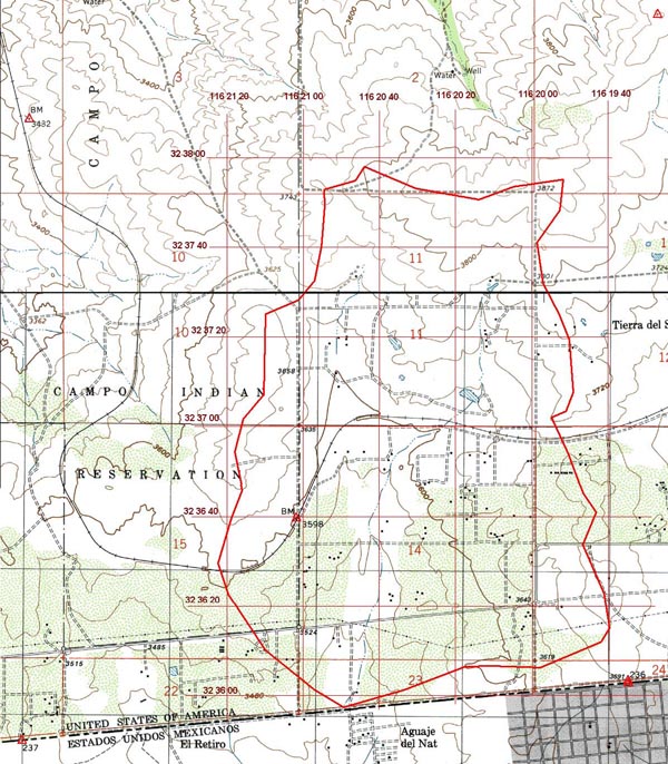
focus of this study is the Tierra del Sol watershed, located immediately east of the proposed Campo landfill site, with
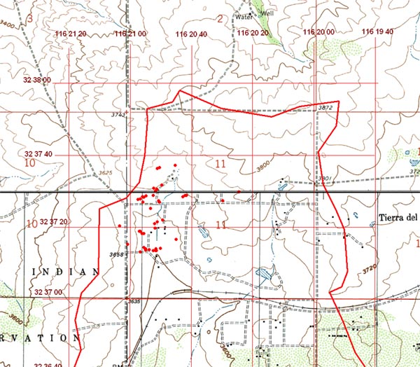
a surface area of 1760 acres, or 2.75 square miles (Fig. 2).
The watershed drains gentle slopes and foothills of California's Peninsular Range,
at an average elevation of 3,600 feet, in a predominantly southern direction.
The watershed features numerous rock outcrops and springs.
The main watercourse, hereafter named Tierra del Sol Creek,
crosses the U.S.-Mexico
border at N 32o 35' 57'' and W 116o 20' 49''.
Once in Mexico, Tierra del Sol Creek flows past Roca Magisterial,
about one kilometer west of the community of Jardines del Rincón.
The creek is in the watershed of Arroyo Las Palmas, which joins Arroyo Alamar in East Tijuana to form the Tijuana River.
In turn, the Tijuana River flows past Imperial Beach, in South San Diego County, to enter the Pacific Ocean.
The Tierra del Sol watershed
land use is a mixture of the native chaparral ecosystem, albeit with a substantial
presence of phreatophytes along well defined moisture paths, a few mesophytes,
and anthropogenic land uses such as ranch clearings and rural housing.
|
Fig. 2 The Tierra del Sol watershed.
|
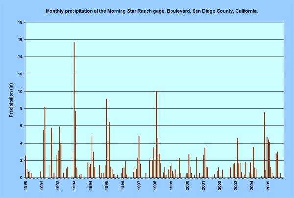
Precipitation data. Precipitation
in the Tierra del Sol watershed has been measured at the Morning Star Ranch from 1990 to the present.
The raingage is located at N 32o 37' 27'' and W 116o 21' 04''.
The record of monthly precipitation is shown in Fig. 3.
The rainy season is from November to April (winter rains), although there are some documented instances of summer rain.
February is the wettest month of record, with 4.09 inches of average precipitation.
|
Fig. 3 Monthly precipitation record at the Morning Star Ranch (1990-2005).
|
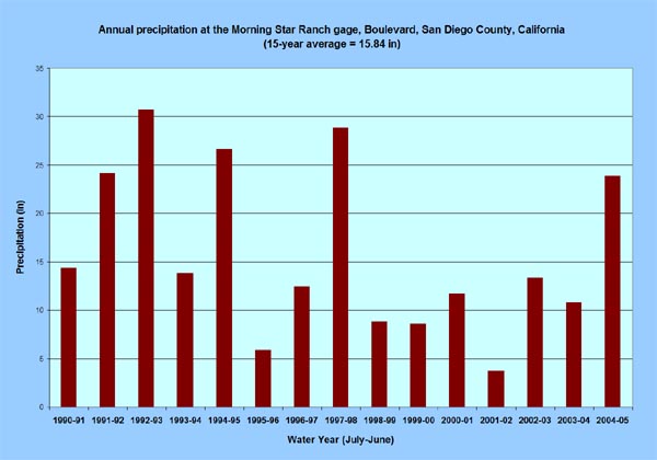
The record of annual precipitation, with the water year defined from July to June, is shown in Fig. 4.
The average precipitation for the 15-year period is 15.84 inches.
The record shows two very wet years, 1992-93 and 1997-98; and three other significantly wet years, 1991-92, 1994-95, and 2004-05.
The years 1991-92, 1992-93, 1994-95, and 1997-98 were El Niño years.
In the year 2004-05, monthly and annual precipitation were near record highs.
The years 1995-96 and 1998-99 were La Niña years, showing substantially below average precipitation.
A La Niña event is the opposite
of an El Niño, leading to cooling, instead of warming, of the sea-surface temperatures (SST) in the Pacific Ocean along the equator.
|
Fig. 4 Annual precipitation at the Morning Star Ranch, 1990-91 to 2004-05.
|
In summary, the precipitation record shows two very wet years (1992-93 and 1997-98),
and one significantly wet year (2004-05), the latter following at the end of a persistent six-year drought (1998-99 to 2003-04).
4. HYDROGEOLOGY
Water level data from three wells located in the Tierra del Sol watershed were compiled and analyzed for this study.
These wells are named: (1) Handdug, (2) Playhouse, and (3) Utz.
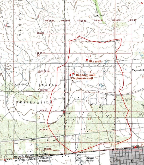
The well locations are shown in Fig. 5.
|
Fig. 5 Location of wells at the Morning Star Ranch, Tierra del Sol.
|
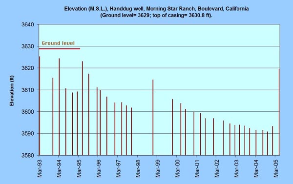
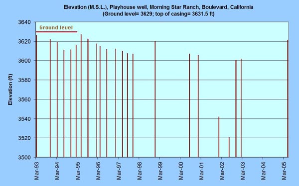
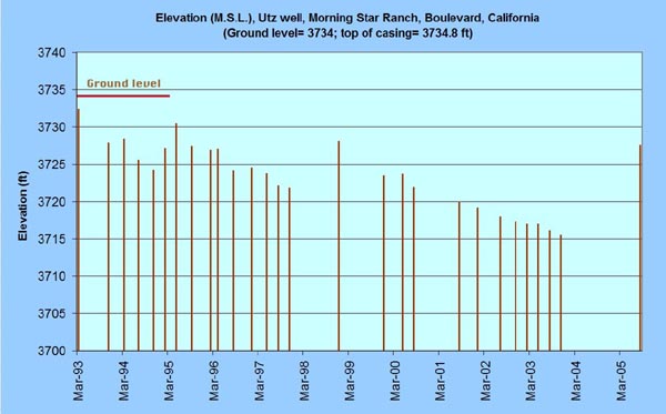
Well data.
Well data spanning the 12-year period from 1993 to 2005 is shown in Figs. 6 to 8.
Fig. 6 shows the Handdug well, Fig. 7 shows the Playhouse well, and Fig. 8 shows the Utz well.
The measurements were performed by San Diego County personnel as part of the county's groundwater monitoring program.
The elevations shown are the water surface in the well, above mean sea level.
The records shows a clear recovery of the groundwater levels in the years 1995, 1998, and 2005,
indicating the effect that these three wet years had on aquifer replenishment.
Significantly, all three wells show water table drawdown during the six-year drought period ranging from 1999 to 2004.
Furthermore, the two dry years of 1995-96 and 1996-97 also show some degree of water table drawdown.
|
Fig. 6 Water-surface elevation at Handdug well.
|
|
Fig. 7 Water-surface elevation at Playhouse well.
|
|
Fig. 8 Water-surface elevation at Utz well.
|
Relation between precipitation and well data.
Analysis of the precipitation and well data reveals
an effective hydraulic connection between surface water and groundwater in the Tierra del Sol watershed.
A fraction of the precipitation percolates into the ground; in turn, a fraction of this percolated water
joins the groundwater, increasing the water-surface elevation in the wells.
The remaining portion (of the percolated water)
eventually returns to the atmosphere as evaporation and/or evapotranspiration. The timing of the groundwater level response is relatively fast,
not exceeding a half season (six months). The paucity of well data precludes a more precise assessment of the
response time; however, the existence of an effective connection between surface and groundwater is clearly borne out by the data.
|
Analysis of the precipitation and well data points to
an effective hydraulic connection between surface water and groundwater in the Tierra del Sol watershed.
|
Geologic characteristics.
The Tierra del Sol region is underlain by the Peninsular Range batholith, which straddles the mountains of central Southern California.
The region lies within the La Posta pluton, a deep-seated igneous intrusion (Walawender et al., 1990).
This pluton varies inward from rim to core, from a sphene-hornblende-biotite tonalite rim to a muscovite-biotite
granodiorite core.2
In the early 1990s, the landfill's engineering
consultants classified the rocks of the Campo landfill as tonalites. However, many of the rocks in Tierra del Sol and vicinity may
actually be granodiorites.3
The rocks are extensively fractured, due either to batholith cooling or tectonic uplift.
There is substantial tectonic activity east of Tierra del Sol, near El Centro (Fig. 9).
In addition, the site is within the area of influence
of the Elsinore fault system (at a distance of less than 22.5 miles)
in San Diego County and other faults in Imperial County
and neighboring northern Baja California. Thus, the region has a potential for earthquake-generated strong ground shaking.
Anecdotal evidence suggests that ground tremors of varying intensities are not
uncommon in the immediate vicinity of Tierra del Sol.4,5,6
Also, well cave-ins have been reported as a direct result of earthquake shaking.7
|
Source: California Geological Survey. |
|
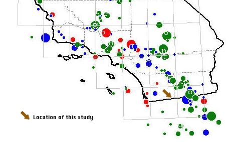
Fig. 9 Magnitude of earthquakes in Southern California
(Magnitudes: small 5.5-5.9; medium 6.0-6.4; large 6.5-6.9; very large 7+). (Data sets: red 1769-1868; blue 1869-1931; green 1932-2000).
|
A striking geological feature of Tierra del Sol, and one possibly related to the fractures,
is the significant number of white, mostly pegmatitic, seemingly vertical dikes that cut across
the study area. These dikes are formed by quartz and feldspar-rich magmas left over in the final stages of crystallization of the granitic rocks.
Since the age of the fractures is not known with certainty, the relation between the dikes and the fractures
is not readily discernible.
One possibility is that the dikes were injected into the fractures which formed in the initial stages of crystallization and cooling of the granitic
rocks. This would place the age of [at least] some of the fractures at about 90-140 million years old (Deméré, 2006).
Another possibility is that the fractures formed as a result of stresses produced
during the [later] uplift of the Peninsular Ranges. In this case they would be only a few million years old.
It is not immediately apparent which one of the above two scenarios is more plausible. If the fractures preceded the dikes,
an east-west preference in dike orientation would suggest that less energy was required to shoulder aside the rock in an orthogonal
(i.e., north-south) direction.
In turn, this would imply denser fracture spacing and/or greater fracture lengths and widths in the east-west direction.
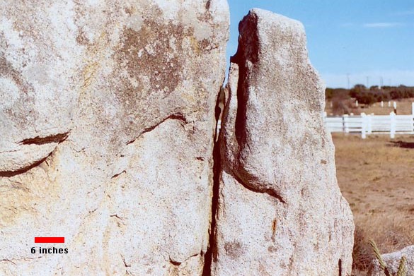
One significantly major dike located on the Turner Ranch in Tierra del Sol,
is about 5-ft wide and 1,465-ft long (Fig. 10).
Notably, this dike trends east-west almost exactly (Fig. 20). A geologic fault crosses this dike near its eastern edge,
in an approximate NE-SW direction.
Significantly, the Turner Ranch's well is
located at or near this fault.
|
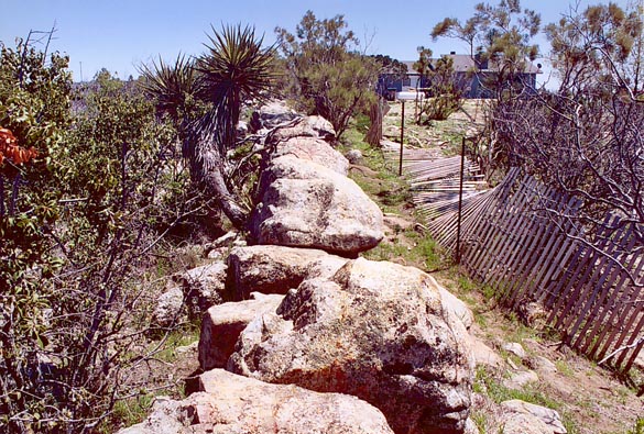
Fig. 10 Major dike in Turner Ranch, Tierra del Sol.8
|
Photogeologic lineaments.
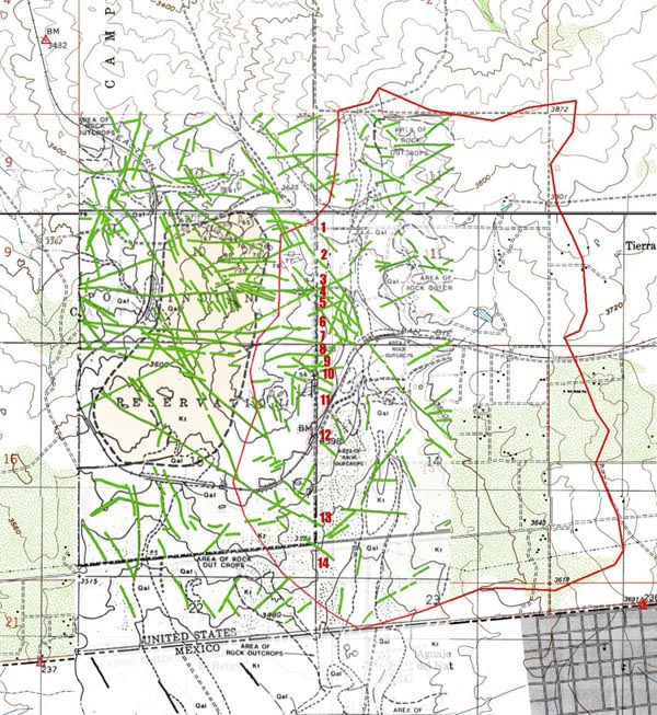
Existing studies have revealed the considerable extent of the fractures in the vicinity of the proposed landfill site.
Figure 11 shows an excerpt of a geologic map prepared in the early 1990s
by the landfill project's engineering consultants.
The proposed landfill site is shown with a light-brown background, immediately west of the Tierra del Sol watershed,
the latter with its boundary highlighted in red.
The photogeologic lineaments, which are highlighted in green,
depict alignments of resistant rock outcrops and variations in the density of vegetation and subtle
tonal texture or color variations.
Many of these lineaments are known to be the expression of fractures and other discontinuities in the weathered and unweathered rocks.
|
Fig. 11 Geologic fractures identified on the Campo
landfill site and vicinity.9
|
A narrow buffer zone, varying from 212 ft to 688 ft in width,
separates the landfill site from the Tierra del Sol watershed.
The landfill's footprint has been selected to ensure that drainage should proceed in the northwestern direction,
toward Lower Campo Creek, and not in the eastern direction, toward the Tierra del Sol watershed.
Limiting the landfill site drainage to the surface drainage assumes
that there is no connectivity between surface water and groundwater.
However, as Fig. 11 shows, this is most likely not the case.
Many of the identified fracture alignments cross the landfill site in a predominantly west-east direction.
At least fourteen (14) fracture alignments cross the boundary between
the Campo Indian reservation and privately owned land immediately east of it (Fig. 11).
Advection vs. diffusion.
In fluid mechanics, as well as in groundwater flow,
the difference between advection and diffusion is largely one of scale. Advection is a first-order process, governed
by the advective term
in the differential equation of fluid motion; diffusion, on the other hand, is a second-order process, governed by the diffusive term.
The terms consist of constant or variable coefficients and partial differential terms; for instance, the advective term
[u ∂u/∂x], in which u is the advective velocity;
likewise, the diffusive term [ν ∂u2/∂x2],
in which ν is the diffusivity coefficient.
|
Flow in fractured-rock aquifers is not typical of groundwater flow. Velocities are higher and travel times shorter
than those prevalent in more traditional [diffusive] hydrogeological settings.
|
In general, an advection-dominated process is much faster than a diffusion-dominated process.
This is because the first derivative (the gradient) is much larger than the second derivative (the square of the gradient).
While diffusion is the governing process in flow through porous media, advection is the dominant process
for flow in open channels (Ponce, 1989).
Therefore, flow in fractured-rock aquifers is not typical of groundwater flow.
Velocities are higher and travel times shorter
than those prevalent in more traditional [diffusive] hydrogeological settings.
Hydraulic conductivity.
In hydrogeology, the hydraulic conductivity expresses the ease with which a fluid is transported through a porous medium (Bear, 1979).
According to Darcy's law, the hydraulic conductivity is a specific discharge (i.e., a flux, or discharge per unit of area)
per unit of hydraulic gradient, with applicable units
L3 L-2 T-1
(Ponce, 1989).
It characterizes the bulk, or macroscopic, velocity (L T-1 units) and not the microscopic velocity,
which may be real but it is much more elusive.
The hydraulic conductivity is commonly expressed in cm/s, or alternatively, in m/day, where 1 cm/s is equivalent to 864 m/day.
In practice, the hydraulic conductivity varies within a very wide range, thirteen (13) orders of magnitude,
from 102 cm/s for the most pervious cases, to
10-11 for the most impervious.
In gravel, the variability of hydraulic conductivity is three (3) orders of magnitude, from 102 cm/s for coarse gravels
to 10-1 for fine gravels;
in fractured rock, the variability is four (4) orders of magnitude, from 10-2
to 10-6 cm/s (Freeze and Cherry, 1979).
In fractured-rock aquifers, porosity is typically much smaller than that of unconsolidated quaternary aquifers.
While the porosity of sand and gravel deposits varies in the range 25-50%, that of fractured rock is less than 10% (Freeze and Cherry, 1979).
The smaller the porosity,
the greater the difference between the matrix velocity
and the fracture velocity.
This difference is particularly marked if the porosity is less than 2%.
In contaminant transport through fractured rock, actual solute velocities, dominated by advection, may be at least
two orders of magnitude greater than the values of bulk hydraulic conductivity (Muldoon, 1994).
Thus, at the upper limit, values of solute velocities in fractured rock may approach
10-2 + 2 = 10-0 cm/s, i.e., 1 cm/s,
which is roughly
equivalent to the hydraulic conductivity of medium-sized gravel.
Variability in well yield.
Well yield is a function of hydraulic conductivity. In fractured rock, water-bearing fractures are responsible for most of the yield,
with very little of it originating from matrix flow. Thus, well yield is directly related to the number, size, and orientation of existing fractures.
To put it concisely, where there is a significant presence of fractures, generally there is ample water;
conversely, where there is ample water, its presence may be attributed to a significant number/size of fractures.
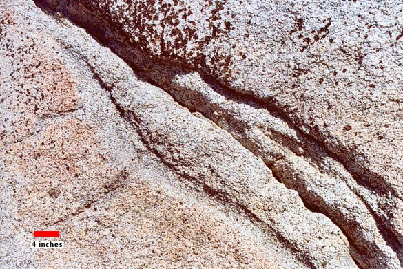
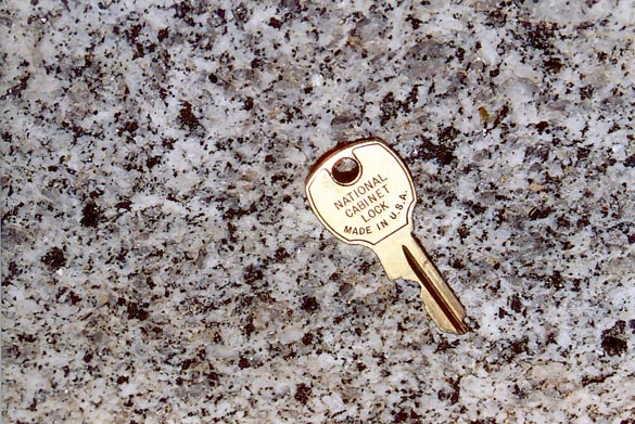
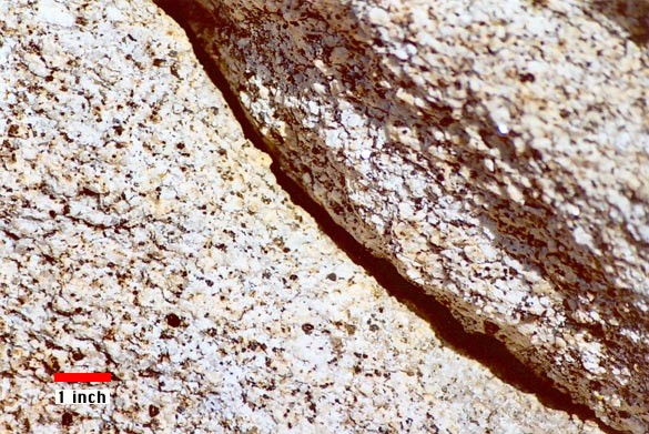
In general, very little yield could be expected from the rock matrix (Fig. 12).
|
Fig. 12 Closeup of matrix structure in rock outcrop at Tierra del Sol.
|
Well yields in fractured-rock aquifers can vary widely.
Well drilling experience in the Tierra del Sol watershed supports this statement,
with the variability explained in terms of whether the wells intersect water-bearing fractures or not.
Success in well drilling is heavily dependent on the size and orientation of the fractures tapped by the well.
One experienced well driller reports wells in the vicinity being as shallow as 5 to 10 ft, and as deep as 600 ft,
both yielding water of excellent quality.10
Another well driller reports yields varying from a few gallons per minute to 400 gpm,
with well yield varying drastically between wells that are only a few feet apart.7
Several examples attest to the variability in well yield and depth in the Tierra del Sol watershed.
In the Morning Star Ranch, the Playhouse well, drilled in 1978 at the end of a severe drought, found water at 4 ft,
drilled through rock for 270 ft of its 300-ft depth, and yielded 100 gpm,4 a substantial yield by
established standards
(Davis and DeWiest, 1966; Freeze and Cherry, 1979).
This same well (Playhouse well) experienced a substantial cave-in and a significant reduction in yield following a strong earthquake in the
1980s.4
The Utz well, also in the Morning Star Ranch, yielded 22 gpm at the depth of 200 ft.4
The Madsen well yielded 25 gpm at a depth of 480 ft.5
The Jeffries well found water at less than 10 ft below the surface, and yielded 30 gpm at a depth of 140 ft.6
The Hucker well found water at a depth of 10 ft, and yielded 14 gpm, with a total well depth of 50 ft.11
5. HYDROECOLOGY
Hydroecology is a relatively new and evolving interdisciplinary science dealing with the
structure and function of natural and human-impacted water-dependent habitats and environments.
Hydroecology is used here to study selected vegetative species present in the Tierra del Sol watershed in terms of their affinity for water.
The aim is to document a potential dependence of the spatial distribution of vegetation on [subsurface] local moisture gradients
which may be linked to the rock fractures.
The chaparral ecosystem.
The ecosystem of the Tierra del Sol watershed consists of mediterranean chaparral on gentle slopes and foothills, and is complemented
with woody riparian vegetation near springs and watercourses, and certain selected mesophytes.
The California chaparral has been studied extensively (Keeley and Keeley, 1988).
It is a community of largely taxonomically unrelated shrubs, albeit with similar ecological characteristics.
These include a relatively extensive root system, a dense canopy, and sclerophyllous (hard) evergreen leaves (Delgadillo, 1992).
Chamise and red shank.
Two closely related chaparral species, chamise (Adenostoma fasciculatum) and red shank (Adenostoma sparsifolium)
are significantly represented in the Tierra del Sol watershed. Notably,
these two shrubs are the only species in their genus.
Chamise is widely distributed throughout California and Baja California, with a range of nearly 800 miles.
In contrast, red shank occurs only in four isolated places in Central California, Southern California, and
Baja California as a co-dominant with chamise, with a range of only 300 miles (Marion, 1943; Sampson, 1944; Hanes, 1965).
Although chamise and red shank have overlapping geographical distributions, Beatty (1984) has noted that
they do not grow in close association within a given stand.
Red shank is commonly found on all aspects of gentle slopes and foothills of inner mountain ranges.
Pure stands of red shank can be found in only 3% of the area in which red shank is the dominant species (Marion, 1943).
Chamise and red shank, although congeners, are not at all alike in appearance.
Stands of chamise chaparral are dull, of dark-green color and uniform in appearance.
The mature chamise plant is a medium-sized shrub 2 to 8 feet tall, with sparse leaf litter.
In contrast, stands of red shank are distinctive, spreading above the general level of the chaparral.
Red shank is a tall, round-topped arborescent plant 6 to 20 feet high, with thick naked stems and considerable leaf litter,
0.5 to 2 inches in depth
(Hanes, 1965).
|
Red shank dominates over chamise on sites with higher moisture content, organic matter, and nutrient availability.
|
There is a substantial difference in the rooting habits of the two species.
Chamise, even though less than half the average size of red shank shrubs, has a more agressive root system,
possessing stronger roots with greater length and vertical penetration.
On the other hand, the roots of red shank are massive, smaller, weaker, and are more likely to spread laterally rather than vertically.
Chamise blooms and sets seed best, with low seed viability, following winters of ample rainfall.
In contrast, red shank blooms well, with low seed set and viability, regardless of the amount of rainfall the previous winter (Hanes, 1965).
Red shank dominates over chamise on sites with higher moisture content, organic matter, and nutrient availability (Beatty, 1984).
Hanes (1965) noted that though both Adenostoma
species resumed growth in early winter, chamise displayed a sudden flush of growth in the spring,
whereas red shank grew more steadily, with continued growth throughout the summer and fall. Chamise flowered in April and May,
whereas red shank flowered abundantly in August. While chamise has an apparent enforced dormancy in the fall,
red shank has been known to experience
substantial autumnal growth, suggesting a sustained moisture source.
It is noted that red shank violates several definitions of sclerophyllous plants. First, it remains physiologically
active during summer drought; thus, it is drought tolerant
without being drought dormant (Hanes, 1965). Secondly, its root morphology is unique among the chaparral.
Its shallow root system suggests that its moisture
for summer growth must come from the top layers of the substrate.
Red shank seems to be a type of shrub well adapted to drought conditions,
but lacking the obvious morphological characteristics suggesting such adaptability (Shreve, 1934).
Thus, the water affinities of red shank appear to lie in between those of the xerophytes, which are well adapted to drought,
and those of the mesophytes, which habitually require a more sustained moisture source.
The spatial distribution of red shank and its possible connection to local moisture gradients associated with rock fractures
merits further study.
Blue elderberry. Under moist conditions, such as near the bottom of ravines or small canyons,
the chaparral coexists with the small woody winter-deciduous Sambucus species and
the flowering ash (Fraxinus dipetala) (Keeley and Keeley, 1988).
One Sambucus species, the blue elderberry (Sambucus mexicana) is present in the flood plains and other mesic locations
of the Tierra del Sol watershed (Fig. 13).
|
Fig. 13 Specimen of blue elderberry, Morning Star Ranch,
Tierra del Sol watershed.12
|
|
The water affinities of the blue elderberry and its preeminent role as an indicator of the presence of
groundwater have been known for almost one hundred years.
Early references to the blue elderberry's moisture habits are scattered throughout the literature.
Ball (1907) has stated that in Southwestern Nevada and Eastern California, the elderberry tree is unknown, except in the vicinity of water.
Spalding (1909) has noted that the blue elderberry, while being structurally a flood-plain mesophyte, it is nevertheless
very limited in its range, growing where there is an ample supply of moisture, such as near irrigation ditches.
In the Southwestern United States, particularly in Southern California's inland hillslopes,
the blue elderberry may be thought of as a meso-hygrophyte,
to indicate that while structurally a mesophyte (Meinzer, 1927),
its water habits resemble those of a hygrophyte, which thrives on wet soil and is more or less restricted to wet sites.
|
In Southern California's inland hillslopes,
the water affinities of the blue elderberry range between those of mesophytes and hygrophytes.
|
The presence of all the specimens of blue elderberry in a selected portion of the
northwestern edge of the Tierra del Sol watershed
was mapped with the aid of a global positioning system.
The location of forty-three (43) elderberry trees are shown in Fig. 14.13
At least three alignments are clearly distinguished
from the data, indicating the potential presence of moisture-laden fractures in the underlying rock.
The presence of other specimens of blue elderberry elsewhere in the Tierra del Sol watershed point to the existence
of sustained moisture sources, possibly fractures, throughout the study area.
Fig. 14 Presence of blue elderberry (S. mexicana)
near the
northwest edge of the Tierra del Sol watershed.
|
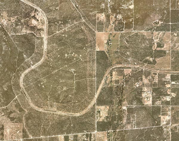
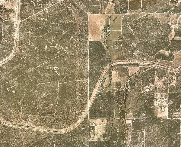
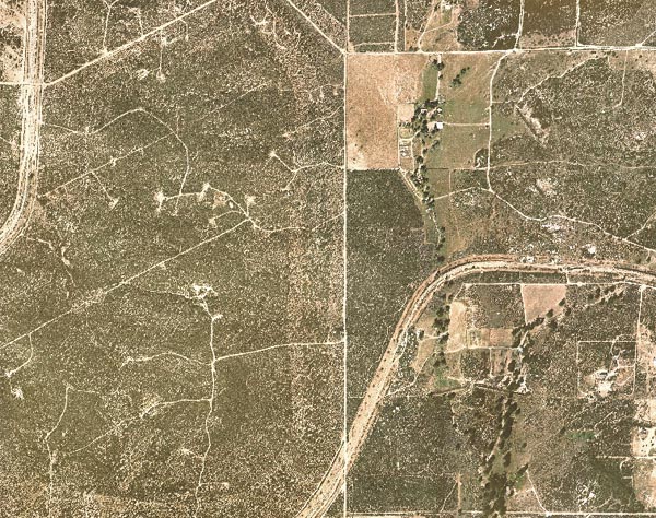
Remote sensing. Figures 15 to 17 show color images of the proposed landfill
site at three different spatial scales, from
larger (Fig. 15) to midsize (Fig. 16) to smaller (Fig. 17).
These images
show the presence of darker spots of approximate longitudinal orientation, referred to as lineaments.
They appear as such or are evident due to contrasts in terrain or ground cover on either side.
If they are of geological origin, the lineaments are usually traced to faults, joints, or boundaries between stratigraphic formations.
When they are related to bedrock features, they are most readily observed in areas where the surficial material is thin
(Moore et al., 2002). This is certainly the case in the Tierra del Sol watershed.
|
| Source: GIS, Department
of Public Works, San Diego County. |
|
Fig. 15 Larger-scale image of the study site.14
|
|
| Source: GIS, Department of Public Works, San Diego County. |
|
Fig. 16 Medium-scale image of the study site.14
|
|
| Source: GIS,
Department of Public Works, San Diego County.
|
|
Fig. 17 Smaller-scale image of the study site.14
|
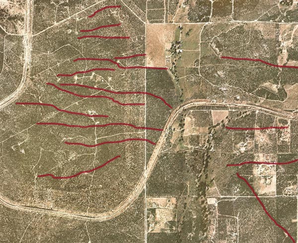
A substantial number of major lineaments can be observed at all three image scales.
Figure 16, in particular, shows a clearly defined lineament
located east of Tierra del Sol Creek, close to the bottom right-hand corner of the figure,
with a predominant northwest to southeast direction. Field inspection showed that this lineament
is constituted by thick stands of red shank (Adenostoma sparsifolium), in association with specimens of scrub oak (Quercus dumosa),
some of which are distinctively large.
This observation confirms that red shank prefers a more mesic (i.e., humid) environment than its congener the chamise (Beatty, 1984).
Several other red-shank dominated lineaments crossing
the boundary between the landfill site to the west and the Tierra del Sol watershed to the east
have been observed.
Figure 18 is the same as Fig. 16, but with readily identifiable lineaments, from photo inspection and field verification,
highlighted in red.
The interpretation of this image is that it is underlain by an extensive system of fractures.
There appears to be no other sensible explanation for the presence of the lineaments.
Field observations and local experience support this statement.
|
| Image source: GIS, Department
of Public Works, San Diego County. |
|
Fig. 18 Readily identifiable lineaments in
the Campo landfill-Tierra del Sol site.14
|
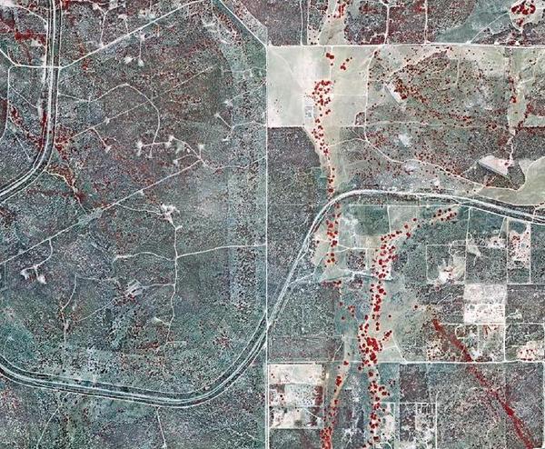
Figure 19 shows an infrared image covering the same area as Fig. 18. Many of the lineaments highlighted in Fig. 18
can be observed in Fig. 19.
Predictably, the major drainage courses (Tierra del Sol Creek and tributaries)
feature riparian forests, which draw their moisture from the groundwater (vadose and phreatic zones).
The lineament in the bottom right-hand corner is located upland,
i.e., it does not follow any clearly defined watercourse. Yet it is seen to consist of large shrubs (red shank)
and trees (oak species) with a demonstrated water affinity.
|
| Source: Geography Department,
San Diego State University. |
|
Fig. 19 Infrared
image of the Campo landfill-Tierra del Sol site.15
|
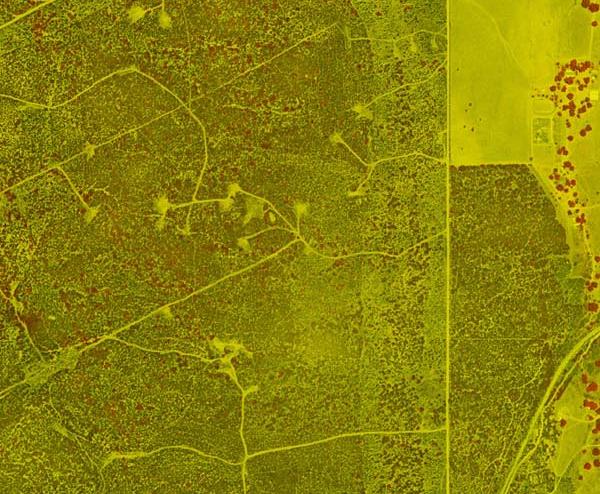
Figure 20 shows a digitally enhanced image of the central portion of the Campo landfill-Tierra del Sol site.
To obtain this figure, Fig. 19 was processed with the
NDVI16 feature of the ERMapper image-processing software, and cropped
to the region of interest.
Many of the lineaments depicted in Fig. 18 are clearly visible in Fig. 20.
|
| Image processed with ERMapper © |
|
Fig. 20 Digitally enhanced image of the Campo landfill-Tierra del Sol watershed boundary.
15
|
6. STREAM MORPHOLOGY
The existence of springs in upland areas is a reliable indicator of an effective hydraulic connection between groundwater and surface water.
The Tierra del Sol watershed is an upland watershed that has its highest point at elevation 3,880 ft, borders
with the headwaters of Campo Creek immediately to the north and northwest, and it is within a few miles of the Tecate Divide to the northeast.
Its lowest point is at its mouth on the Mexican border, at elevation 3,440 ft.
The total watershed relief is 440 ft.
Figure 21 shows the location of eleven (11) springs in the Tierra del Sol watershed.
Most of these springs drain northern slopes at elevations above 3,700 ft.
The lack of a substantial number of springs along the western boundary of the Tierra del Sol watershed
appears to indicate that the local drainage is primarily through the subsurface, from the fractures, downgradient, west to east,
to be intercepted by the Tierra del Sol drainage. The latter flows in a predominant north-south direction.
Fig. 21 Location of springs (S) in the Tierra del Sol watershed,
with east-west trending major dike shown in red.
|
In Fig. 21, note that the southernmost spring is located precisely at
the western extremity of the 1,465-ft dike shown in Fig. 10.
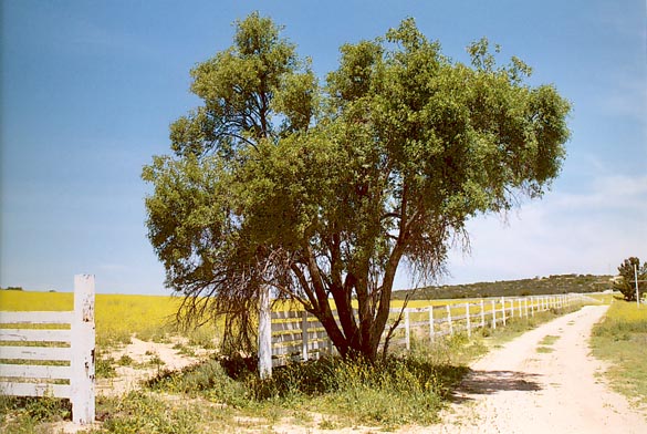
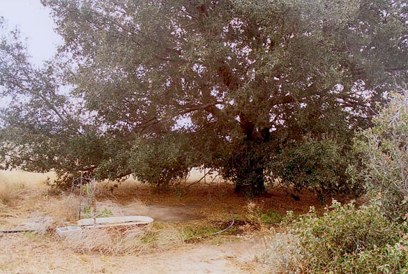
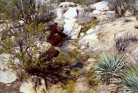
This spring sustains a rather large isolated specimen of coast live oak (Quercus agrifolia), shown in Fig. 22.
This tree appears in Fig. 19, at the western edge of the dike (compare Figs. 19 and 20).
Although drought tolerant, a coast live oak requires some moisture for its normal development.
Thus, the presence of an oak specimen near a spring in the Tierra del Sol watershed
is further evidence of a hydraulic connection between surface water and
groundwater.
|
Fig. 22 A coast live oak near west end of southernmost spring in the Tierra del Sol watershed.
Note the presence of substantial moisture on the ground.17
|
The springs lead to a network of small streams which collect to form two major tributary drainages. Eventually,
the latter join to form the main channel of Tierra del Sol Creek,
which flows southward to the Mexican border. The existing metallic fence along the border acts as an effective impediment
to the flow, which results in considerable water ponding on the U.S. side during floods.
On the Mexican side of the border, within the confines of
Roca Magisterial,
there is physical evidence that prior to the late 1990s, before the installation of the metallic border fence,
the infrequent floods were large enough to carve two gullies.
Several springs originate in these gullies, and there is physical evidence (a well and a small concrete dam and associated pond)
that this water has been or it is
being utilized
for human and animal consumption.18
7. GROUNDWATER HYDRAULICS
The siting of a landfill on top of a fractured-rock aquifer poses a serious threat to groundwater quality.
Typically, fractured-rock aquifers are heterogeneous and anisotropic, i.e., their physical
properties vary not only with location but also with direction, rendering the aquifer difficult to characterize (Fig. 23).
Among hydrogeologic properties, the hydraulic conductivity and permeability describe the rate of groundwater movement.
A number of case studies serves to illustrate the wide range of variability in hydraulic conductivity.
Hydraulic conductivity in fractured-rock aquifers.
A comprehensive study of a fractured-rock aquifer in the Clare Valley, South Australia,
revealed a variability in hydraulic conductivity of ten (10) orders of magnitude, from 102 m/day
in aquifer pump tests to 10-8 m/day in tests on the rock cores (matrix flow) (Love et al., 2001).
In Door County, Wisconsin, measurements of bulk hydraulic conductivity of a fractured-rock aquifer, using multiwell pumping tests,
showed a narrow range of variability, less than two (2) orders of magnitude, from
1.7× 10⁻⁴ ft/s to
4.9× 10⁻⁵ ft/s, with a geometric mean of
7.5× 10⁻⁵ ft/s (Muldoon, 1994).
However, short-interval packer tests conducted over the fracture and matrix portions of the aquifer yielded a much wider range, in excess of
six (6) orders of magnitude, from
1.4× 10⁻² ft/s to
2.3× 10⁻⁸ ft/s, with a geometric mean of
9.5× 10⁻⁶ ft/s, or 0.82 ft/day.
Moreover, tracer tests yielded groundwater velocities on the order of 2.0× 10⁻³ ft/s (173 ft/day),
which is 211 times greater than the geometric mean of the packer tests.
According to Muldoon (1994), the tracer results are consistent with
the hydraulic conductivities derived from the packer tests and not with those derived from the pumping tests.
Thus, the measured difference between fracture and matrix velocities in this fractured-rock aquifer was in excess of two (2) orders of magnitude.
|
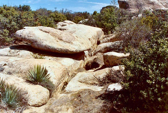
Fig. 23 Closeup of fracture in rock outcrop at Tierra del Sol.
|
In Manitoba, Canada, an extensive study of several fracture zones in crystalline rock at the Lac Du Bonnet batholith
revealed a complex pattern of permeability within the fracture zone at the regional scale.
Permeabilities ranged over six (6) orders of magnitude, with the higher permeabilities appearing to form distinctive large-scale channel-like patterns
that were sized up to 1 km in areal extent. At the local scale, permeabilities were observed to change by as much as six (6) orders of magnitude
over distances of a few meters within the fracture zone, and isolated pockets of high permeability were shown to reside within larger regions of low
permeability. This case study highlights the difficulties that may arise in trying to interpret the hydrogeologic characteristics of
fracture zones in situations where the exploratory boreholes are sparse (Davidson and Kozak, 1988).
These and other similar studies have shown conclusively that hydraulic conductivities
are likely to vary over a wider range in fractured-rock aquifers
than in comparable sedimentary or unconsolidated quaternary aquifers.
In addition, anisotropy prevails in fractured rock, resulting in fracture velocities that could be two to three orders of
magnitude greater than the matrix velocities (Davis and DeWiest, 1966; Muldoon, 1994).
A wide range of variability in hydraulic conductivity is likely to be the case in the Campo landfill-Tierra del Sol watershed.
Local experience confirms the extreme anisotropy of the Campo-Tierra del Sol aquifer.
As an example, during the Campo landfill site work in the early 1990s, a local well driller reported the following:
"...When we were washing wells on the northwest side, just north of
the road and east of the railroad tracks, we
dumped about 3,000 gallons of water down the well closest to the road. The water never came back and did not show up in the other two wells
that were less than 20 ft away! We had another well on the West side that did the same thing..." 19
Solute travel time.
Fractures can cause markedly anisotropic behavior, particularly with regard to contaminant transport, which
tends to be dominated by advection, with little diffusion of pollutant concentration (National Research Council, 2000).
In principle, the flow direction in fractured-rock aquifers can differ
from the direction of the prevailing hydraulic gradient by up to 90o (Love et al., 2001). Therefore, preferred flow
paths in fractured-rock aquifers may cross surficial watershed boundaries, defying conventional hydrological characterization.
Fractured-rock aquifers are particularly sensitive to contamination due to the rapid and somewhat unpredictable movement of contaminants through fractures.
In sedimentary aquifers, strategies to protect water-supply wells usually employ a capture zone,
the boundary of which is monitored for contamination.
The travel time from the boundary of the capture zone to the well is usually taken as a constant, for example, 10 years
(National Research Council, 1996).
|
Travel times from capture zone to nearby wells in the Tierra del Sol watershed, a distance of about 600 m, could be less than 1 day.
|
With estimated fractured-rock solute velocities comparable
to the hydraulic conductivity of medium-sized gravel, estimated at 1 cm/s (864 m/day),
advection-dominated travel times from capture zone to nearby wells in the Tierra del Sol watershed, a distance of about 600 m (2,000 ft),
could be less than 1 day.
The potential for such a fast hydraulic connection is supported by accounts
from local property owners, who describe the effects on their wells from extensive drilling, borehole washing, packer testing and other
activities conducted
on the landfill site in the early 1990s. Within a short time after the tests,
water pumped from local wells was contaminated with sand and well-drilling debris.
According to eyewitness accounts, the sand appeared (or disappeared)
with concurrent activity (or nonactivity) on the landfill wells, suggesting the existence of an effective hydraulic connection
between the landfill site and private domestic local wells.20
Risk of groundwater contamination.
Landfill monitoring to control contaminated plumes resulting from liner failure is difficult at best.
This is due to the practical impossibility of accurately characterizing a complex fractured-rock aquifer system.
Fracture size, density and orientation may vary spatially, and no reasonable monitoring well system may be able to account for the spatial variability.
Certain design features attempt to mitigate the difficulties inherent in monitoring landfills built on top of fractured-rock aquifers.
For instance, a double-liner system is considered to be safer than a single-liner system.
However, a double-liner system does not completely eliminate the possibility of groundwater contamination.
The rationale for the double-liner system assumes that the primary liner, i.e., that closest to the landfill, will fail first,
and the leachate will be recovered subsequently, or be retained by the secondary liner.
However, there is the
possibility that the secondary liner will fail first, with the breach remaining inactive until the primary liner fails.
The probability that the contaminant plumes will be missed by monitoring wells is high,
since typically these wells are spaced at distances far exceeding the width of the plume
(Note that the original design for the Campo landfill called for monitoring wells at an average distance of 500 ft apart).
Haitjema (1991) has placed the matter in the proper perspective
by observing that the design of monitoring-well systems in fractured-rock aquifers
"is a nightmare and usually not more than a blind gamble."
Although it is technically feasible to reduce the
distance between monitoring wells to implement a line of defense resembling a picket fence,
the cost would be prohibitively high. Moreover, such a high well density, if implemented, is likely to change the local hydraulics and
do more harm than good in the long run. This is because a borehole acts as a high-permeability pathway that connects fractures
which previously were unconnected (Shapiro, 2001).
|
The probability that the contaminant plumes will be missed by monitoring wells is high,
since typically these wells are spaced at distances far exceeding the width of the plume.
|
By most accounts, the water pumped from wells in Tierra del Sol is of excellent quality.4, 10
Thus, the landfill's presence will constitute a potential risk to this scarce natural resource.
In the event of aquifer contamination, the spatial heterogeneity and anisotropy of the fractured-rock aquifer may render cleaning and/or remediation
efforts impractical.
It is noted that the Southwestern United States, and
particularly the state of California, are poised to face significant
water shortages as the 21st century sets in.
Solid-waste dry-tomb landfills lying on top of fractured-rock aquifers
represent a significant threat to groundwater quality, particularly in areas where these aquifers have been
designated as sole source.
Given enough time, the plastic sheeting used in composite liners may deteriorate.
Landfill covers may be unable to keep moisture out of the landfill for as long as the wastes represent a threat.
The crucial issue remains as to whether an effective leakage-monitoring system can be designed and implemented for a landfill lying on top of a
fractured-rock aquifer such as Tierra del Sol's.
A related concern is whether it is possible to operate and maintain the landfill facility
for an indefinite period.
The operation of the leakage-monitoring system would have to be guaranteed for a long time,
since the mere closure of the landfill does not preclude the possibility of an eventual failure of the liner system.
8. SYNTHESIS
The surface and groundwater hydrology of the Tierra del Sol watershed are shown to be connected through major fractures, springs, streams and wells.
Annual pulses in precipitation are linked to annual pulses in well data, which confirms the existence of an active connection between surface
water and groundwater.
The underlying fractured-rock aquifer is heterogeneous and anisotropic, thereby defying hydrogeological characterization.
Flow through fractured rock is dominated by advection, resulting in travel times that are typically several orders of magnitude greater than
diffusion-dominated matrix flows.
The project seeks to place a major landfill on top of a fractured-rock aquifer. The rock is extensively fractured,
as confirmed by geologic, photogeologic, ground, and other evidence.
Unlike sedimentary aquifers, where diffusion is likely to prevail,
in fractured-rock aquifers advection is the dominant mechanism.
Therefore, the transport of flow and contaminants in the event of liner failure will be relatively fast,
downgradient, through the fractures, and directly into adjacent surface-water and groundwater bodies.
Solute travel times from capture zone to nearby wells could be less than one (1) day, counteracting the argument that leakage can be effectively controlled.
|
In a properly sited landfill,
the transport of water and contaminants occurs primarily by diffusion, rather than by advection.
|
Landfill monitoring to prevent and control leachate leaks and groundwater contamination is difficult at best.
Since liner failure can occur randomly at any place and at any time, a reasonable monitoring well density
cannot completely eliminate the possibility of a leak gone undetected for a sufficiently long time.
It is noted that in a properly sited landfill,
the transport of water and contaminants occurs primarily by diffusion,
rather than by advection. Diffusion serves to attenuate and mitigate the negative effects of contaminant plumes on nearby water supplies.
9. CONCLUSIONS
The following conclusions are derived from this study:
Hydrology. Based on the available evidence,
it appears that the groundwater and surface water of the Tierra del Sol
watershed are hydraulically connected.
The presence of several springs and numerous rock fractures indicates that water flows readily from the fractured-rock aquifer
to the wells, springs, creeks, and streams of Tierra del Sol watershed.
The record of fifteen (15) years of precipitation and well data supports this statement.
Hydrogeology. Existing fracture maps reveal the extent to which the underlying
aquifer is fractured.
At least fourteen (14)
major fractures cross the boundary between the Campo Indian reservation and adjacent private property in the Tierra del Sol watershed.
Local well-drilling experience confirms the well yield and depth variability typical of fractured-rock aquifer systems.
Eyewitness accounts provide anecdotal evidence of an effective and fast hydraulic connection between landfill capture zone and nearby wells.
Hydroecology. Specimens of blue elderberry (Sambucus mexicana)
seem to align themselves along major fractures, where
moisture can be potentially sustained for long periods.
Thick stands of red shank (Adenostoma sparsifolium) constitute the predominant species
in several of the lineaments identified in aerial images and confirmed by field inspection. Unlike the chamise (Adenostoma fasciculatum),
its closely related and more widely distributed chaparral species, red shank
is a tall arborescent shrub
which thrives on more humid and fertile sites
such as those that most likely prevail in the vicinity of the fractures.
The spatial distribution of blue elderberry and red shank points to the existence of local subsurface moisture gradients
which could be tied to the rock fractures.
Stream morphology. Springs in the Tierra del Sol watershed drain primarily
slopes along its northern boundary.
The lack of a substantial number of springs along the western boundary appears to indicate that the local drainage
is primarily through the subsurface, from the fractures, downgradient to the Tierra del Sol drainage.
The existence of a spring at the downstream end of a major geologic dike points to an effective hydraulic
connection between surface water and groundwater.
Groundwater hydraulics. With estimated fractured-rock
solute velocities comparable to the hydraulic conductivity of
medium-sized gravel (1 cm/s, or 864 m/day),
travel times from the landfill's capture zone to private domestic wells nearby in Tierra del Sol,
which is a distance of approximately 600 m, could be less than 1 day.
Anecdotal evidence indicates that the actual travel time may not be too far from this value.20
10. SUMMARY
The impact that the proposed Campo landfill will have on the surface water and groundwater of the Tierra del Sol watershed is examined
from an interdisciplinary perspective.
The proposed Campo landfill is located within the Campo Indian reservation, in East San Diego County, California, in the headwaters of Lower Campo Creek.
The Tierra del Sol watershed is adjacent to the landfill site, immediately east of it.
This study has examined
the hydrology, hydrogeology, hydroecology, stream morphology, and groundwater hydraulics of the site and its vicinity.
The effectiveness of the connectivity between surface water and groundwater is assessed
by documenting the timing response of the water-table elevation to precipitation.
It is shown that annual upward pulses in precipitation produce corresponding annual upward pulses in groundwater level,
confirming the existence of an active connection between surface water and groundwater in the vicinity of Tierra del Sol.
Existing fracture maps show the extent to which the underlying aquifer contains fractured rock
that would render the aquifer difficult to characterize (Fig. 24).
Fractured-rock aquifers of the type found in the Campo-Tierra del Sol site are
heterogeneous and anisotropic. Hydraulic conductivities in fractured-rock aquifers can vary greatly, typically six (6) orders of magnitude,
but could be vary up to ten (10) orders of magnitude in some instances.
|
Fig. 24 Fracture in rock outcrop in Tierra del Sol watershed.21
|
Flow velocities and contaminant-transport rates in fractured rock can be high,
resulting in early contaminant appearance at neighboring wells, springs, and streams. The
flow direction in fractured-rock aquifers can differ from the direction of the prevailing hydraulic
gradient by up to 90o. Thus, preferred flow paths in fractured-rock aquifers may
cross surficial watershed boundaries.
Field inspections show that certain types of woody vegetation, especially those with documented moisture affinities, such as
the blue elderberry tree (Sambucus mexicana), align themselves along seemingly longitudinal paths.
In particular, the blue elderberry has a peculiar ecology; while structurally resembling a mesophyte, its water habits are similar
to those of a hygrophyte. This fact strongly implies the existence of local moisture gradients, and, in the present context, fracture zones,
which sustain the blue elderberries.
Observation of aerial images show that the Campo-Tierra del Sol site
is transversed by several major lineaments.
Ground-truth inspections have confirmed that many of
these longitudinal vegetative associations are constituted by dense stands of red shank (Adenostoma sparsifolium).
This is a chaparral-type arborescent tall shrub which thrives on more humid and mesic locations than its more common congener, the
chamise (Adenostoma fasciculatum).
The apparent connection between red shank and a sustained moisture source merits further study.
Springs in the Tierra del Sol watershed primarily drain its northern slopes (Fig. 25).
The absence of major spring presence on the
western slopes would seem to indicate that drainage across the Campo-Tierra del Sol watershed boundary is primarily through the subsurface,
from the fractures to the streams. The presence of a large coast live oak (Quercus agrifolia) in the immediate vicinity of a spring (Fig. 21)
is live evidence of an effective hydraulic connection between surface water and groundwater.
|
Fig. 25 Spring in rock outcrop in northern slope of Tierra del Sol watershed
at N 32o 37' 21.6"
and W 116o 20' 39". 21
|
Siting a major landfill project on top of a fractured-rock aquifer such as Tierra del Sol's
constitutes a veritable risk to the local population,
on both sides of the U.S.-Mexico border.
Moreover, it is a public-health hazard, since the Tierra del Sol aquifer is part of the federally designated Campo-Cottonwood Creek Creek
Sole Source Aquifer.1 No reasonable mitigation program can substitute for the degradation of
water quality in the event of liner failure.
ENDNOTES
|
| | 1 |
The Campo-Cottonwood Creek Sole Source Aquifer was designated as such on May 5, 1993,
under the authority of Section 1424(e) of the Safe Drinking Water Act
(Federal Register Citation-49 FR 2948, January 24, 1984).
An aquifer can be named a Sole Source Aquifer by the Administrator of the Environmental Protection Agency
if the aquifer supplies 50% or more of the drinking water for an area and there are no reasonably
available alternative sources should the aquifer become contaminated. |
| 2
|
Tonalites and granodiorites are similar in mineral composition.
A tonalite is a plutonic (intrusive) rock where
the percentage of plagioclase feldspar, relative to the combined content of alkali and plagioclase feldspars,
is greater than 90;
in a granodiorite, the percentage varies between 65 and 90 (American Geological Institute, 1997). |
| 3
|
A geologic map of the La Posta pluton classifies the rocks of Tierra del Sol and vicinity as
sphene-biotite granodiorites with both large- and small-biotite facies. The large-biotite facies is characterized
by an abundance of large (up to 1 cm) pseudohexagonal books of biotite,
which impart a distinct "salt and pepper" appearance to the outcrops (Walawender et al., 1990). |
| 4
|
Interview with Ed Tisdale, Tierra del Sol, February 9, 2006. |
| 5
|
Interview with Sharon Madsen, Tierra del Sol, March 24, 2006. |
| 6
|
Interview with Lorna Jeffries, Tierra del Sol, April 8, 2006. |
| 7
|
As written by James W. McGuffie (General Engineering "A", Water Well Development C-57, License #312853) in a letter
to Mr. Harry Seraydarian, Director, Water Management Division,
Environmental Protection Agency, San Francisco, California, dated February 26, 1992. |
| 8
|
Photo date: April 25, 2006. |
| 9
|
The lineaments shown in this figure are based on a preliminary fracture map prepared by Dames and Moore, Inc., the landfill's engineering consultant.
This fracture map was released by Kent Atkins, Mid-American Waste Systems hydrogeologist, in a letter
to Donna Tisdale dated March 11, 1991.
It is noted that the fracture map included in the Final Environmental Impact Statement (FEIS), dated November 1992 (Fig. 3.1-10),
shows only the longer or major lineaments. After inquiring about the difference between the two maps,
Donna Tisdale was told that the preliminary facture map had been "edited" by the Bureau of Indian Affairs
for the FEIS release. |
| 10
|
As written by Frank A. Murphy, of Murphy's Well Drilling (California Waterwell Drilling License #505834), in a letter
to Mr. Harry Seraydarian, Director, Water Management Division,
Environmental Protection Agency, San Francisco, California, dated March 4, 1992. |
| 11
|
Interview with JoEllen Hucker, Tierra del Sol, April 5, 2006. |
| 12
|
Photo date: May 11, 2006. |
| 13
|
The position accuracy of the GPS Garmin model 76S used here is
less than 3 m when receiving WASS corrections, i.e.,
in open land or marine applications. Accuracy can be reduced
when trees and mountains obstruct the view of the horizon. |
| 14
|
Image date: November 2004. |
| 15
|
Image date: April 2000. |
| 16
|
The Normalized Difference Vegetation Index (NDVI) enhances the contrast between vegetation and soil/rock.
It is defined as
NDVI = (r4 - r3) / (r4
+ r3),
in which r3 is the
reflectance in the red (630 to 690 nanometers) and
r4 is the
reflectance in the near visible infrared (760 to 900 nanometers). |
| 17
|
Photo date: March 3, 2006. |
| 18
|
On April 13, 2006, a field inspection revealed that there are two
gullies just south of the border fence, a larger one averaging 4 ft deep and 16 ft wide, and a smaller one, about 3 ft deep and 6 ft wide.
Each gully has at least one spring. At a short distance downstream,
the gullies join to form a small stream.
On the day of the inspection, the flow of this stream was estimated at 3-5 gpm. |
| 19
|
As written by Ken Alquire, well drilling worker, in a letter
to Mr. Harry Seraydarian, Director, Water Management Division,
Environmental Protection Agency, San Francisco, California, dated March 30, 1992. |
| 20
|
As reported in the Alpine Sun ("Landfill neighbors complain sand clogs their wells"), Alpine, San Diego County, on September 16, 1992. |
| 21
|
Photo date: March 24, 2006. |
| |
REFERENCES
American Geological Institute (1997). Glossary of Geology. Julia A. Jackson, editor, Alexandria, Virginia.
Ball, S. H. (1907). A geologic reconnaisance of Southwestern Nevada and Eastern California. U.S. Geological Survey Bulletin No. 308,
United States Government Printing Office, Washington, D.C.
Bear, J. (1979). Hydraulics of groundwater. McGraw-Hill, New York.
Beatty, S. W. (1984). Vegetation and soil patterns in Southern California chaparral communities. In B. Dell, editor, Medecos IV: Proceedings,
4th International Conference on Mediterranean Ecosystems, August 13-17, 1984, The Botany Department,
University of Western Australia, Nedlands, Australia, 4-5.
Davidson, C. C., and E. T. Kozak. (1988). Hydrogeological characteristics of major fracture zones in a granite batholith of the Canadian shield. Proceedings
of the 4th Canadian/American Conference on Hydrogeology, Banff, Alberta, Canada, June 21-24, 1988,
B. Hitchon and S. Bachu, editors, National Water Well Association, Dublin, Ohio, 53-59.
Davis, S. N., and R. J. M. DeWiest. (1966). Hydrogeology. John Wiley and Sons, New York.
Delgadillo, J. (1992). Florística y ecología del norte de Baja California. Universidad Autónoma de Baja California, México, 345 p.
Deméré, T. A. (2006). Geology of San Diego County, California. San Diego Natural History Museum, Paleontology Department, visited on
11 May 2006.
Freeze, R. A., and J. A. Cherry. (1979). Groundwater. Prentice-Hall, Englewood Cliffs, New Jersey.
Haitjema, H. M. (1991). Ground water hydraulics considerations regarding landfills. Water Resources Bulletin, 27(5), October, 791-795.
Hanes, T. L. (1965). Ecological studies of two closely related chaparral shrubs in Southern California. Ecological Monographs, 35(2), 213-235.
Keeley, E. J., and S. C. Keeley. (1988). "Chaparral," in North American Terrestrial Vegetation, edited by M. G. Barbour and W. D. Billings,
Cambridge University Press, Cambridge, UK.
Love, A. J., P. G. Cook, G. A. Harrington, and C. T. Simmons. (2001). Groundwater flow in the Clare Valley. Department of Water Resources,
Government of South Australia, Adelaide, Australia.
Marion, L. H. (1943). The distribution of Adenostoma sparsifolium. American Midland Naturalist, 29(1), January, 106-116.
Meinzer, O. E. (1927). Plants as indicators of ground water. U.S. Geological Survey Water-Supply Paper No. 577,
United States Government Printing Office, Washington, D.C.
Moore, R. B., G. F. Scharz, S. F. Clark Jr., G. J. Walsh, and J. R. Degnan. (2002).
Factors related to well yield in the fractured-bedrock aquifer of New Hampshire.
U.S. Geological Survey Professional Paper 1660, 51 p. http://pubs.usgs.gov/pp/pp1660/
Muldoon, M. A. (1994). Tracer study for characterization of groundwater movement and contaminant transport in fractured dolomite.
University of Wisconsin Water Resources Institute, visited on 11 May 2006.
National Research Council. (2000). Investigating groundwater systems on regional and national scales.
Committee on USGS Water Resources Research, National Academy Press, Washington, D.C.
National Research Council. (1996). Rock fractures and fluid flow: Contemporary understanding and applications.
U.S. National Committee for Rock Mechanics,
National Academy Press, Washington, D.C.
Ponce, V. M. (1989). Engineering hydrology, principles and practices.
Prentice-Hall, Englewood Cliffs, New Jersey.
Sampson, A. W. (1944). Plant succession on burned chaparral lands in Northern California. University of California
Agricultural Experiment Station Bulletin 685, Berkeley, California, March, 144 p.
Shapiro, A. M. (2001). Characterizing groundwater chemistry and
hydraulic properties of fractured-rock aquifers using the multifunction bedrock-aquifer transportable testing tool (BAT3).
U.S. Geological Survey Fact Sheet FS-075-01, 06 May 2006, 4 p. http://toxics.usgs.gov/pubs/FS-075-01
Shreve, F. (1934). The problems of the desert. The Scientific Monthly, 38(3), March, 199-209.
Spalding, V. M. (1909). Distribution and movement of desert plants. Publication No. 113, Carnegie Institution of Washington, Washington, D.C., 5-17.
Walawender, M. J., R. G. Gastil, J. P. Clinkenbeard, W. V. McCormick, B. G. Eastman, R. S. Wermicke, M. S., Wardlaw, S. H. Gunn, and B. M. Smith. (1990).
Origin and evolution of the zoned La Posta-type plutons, eastern Peninsular Ranges batholith, Southern and Baja California.
In "The Nature and Origin of Cordilleran Magmatism," J. Lawford Anderson, editor, Memoir 174,
Geological Society of America, Boulder, Colorado.
|
Fig. 26 Fractured rock outcrop, Tierra del Sol watershed.
|
REVIEWERS
This web document was peer reviewed by Timothy Cass (hydroecology),
Robert Curry (hydrology, stream morphology), and
C. Monte Marshall (geology, geophysics).
| http://tierradelsol.sdsu.edu |
© 2006, 2013 Victor M. Ponce |
130930 |
|
|
|