 |
|
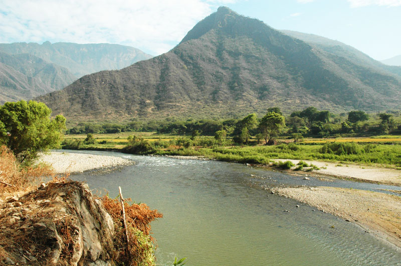
Fig. 1 Proposed damsite at |
LAMBAYEQUE, PERU
TASK 5: ENVIRONMENTAL IMPACT ASSESSMENT
PART 2: SECTIONS 2-3
July 24, 2009
Dr. Victor M. Ponce
Environmental Consultant
2. BACKGROUND
The La Leche River is one of fifty-two (52) rivers that drain the western slopes of the Western Range of the
Peruvian Andes (Carpio, 1999).
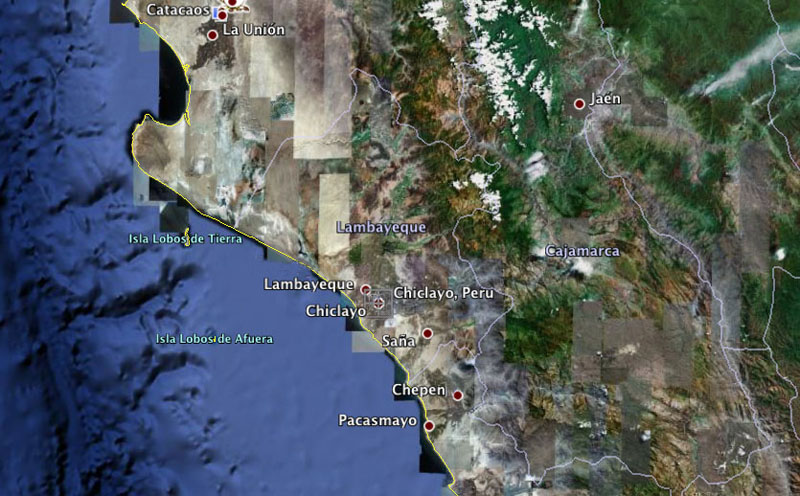
Its watershed is located within the departments of Lambayeque and Cajamarca (Fig. 3).
The steep mountain range, with slopes averaging more than 30% and a significant amount of rock outcroppings,
is conducive to short times of concentration and, consequently, to large flood peaks. The flood risk is exacerbated during strong
El Niño events, which recur every 8 to 15 years (Ponce and Shetty, 2008). These events temporarily change the regional
climatic patterns, from dry to wet, and produce floods which cause substantial damage to existing infrastructure and ecosystems.
 |
|
Fig. 3 Satellite photo of coastal northern Peru, showing Lambayeque and Cajamarca (Source: Google Earth) |
In the aftermath of the El Niño events of 1983 and 1998, which caused widespread flooding, PEOT has formulated a project to enhance flood control and water conservation in the watershed of the La Leche river. Measures for flood control can be either structural or nonstructural. Typical structural measures include levees along the river and dams for upstream storage. Nonstructural measures include watershed treatments and flood proofing.
Levees have been built for centuries in many rivers around the world. Levees can be readily built to any reasonable height; however, levee failure remains a distinct possibility, since overtopping cannot be ruled out. In an overtopping failure, the rushing water, flowing at higher elevation, usually causes more damage than if the levee had not been there in the first place. In addition, levees sequester nutrients and inhibit nutrient replenishment in the flood plain. Aesthetically, levees result in the loss of the sight of the river, which is now being opposed by an increasing number of people. Experience with major rivers such as the Mississippi in the USA, where levees have been built for more than 200 years, shows that the "hold by levees only" strategy is flawed in the long term (McPhee, 1989).
Dams have been used for flood control and water conservation since ancient times. In the past century alone, a large number of dams have been built in the U.S. and elsewhere, many of them for the double purpose of flood control and water conservation. Dams are usually built directly on the streams, and this constitutes in-stream storage. However, dams have a tendency to retain sediment that otherwise would flow unimpeded downstream. This fact is usually given as a negative aspect of dams, particularly of those that are located in-stream. Thus, the benefits of off-stream storage are now becoming more apparent. Dam failure due to overtopping remains a possibility, particularly in the case of rock-fill dams. To reduce the risk of failure, the overflow spillway is sized to adequately pass the Probable Maximum Flood (PMF), which is associated by the Probable Maximum Precipitation (PMP). The PMP is the theoretically greatest depth of precipitation that is physically possible over a given watershed in a given geographic location.
Watershed treatments can help manage floods and mitigate flood damage. Watershed treatments involve distributed measures across the watershed
with the aim to encourage infiltration, lengthen times of concentration, and foster runoff diffusion. The distributed nature of
watershed treatments is usually given as a reason why the technology is not more widespread. Flood proofing consists of the techniques for
building in the flood plain, out of reach of recurrent flood stages. As with watershed treatments, the distributed nature of
flood proofing limits its wide applicability.
3. PROPOSED ACTIONS
The proposed actions are the construction of dams to retain floodwaters
and store water for irrigation and domestic water supply.
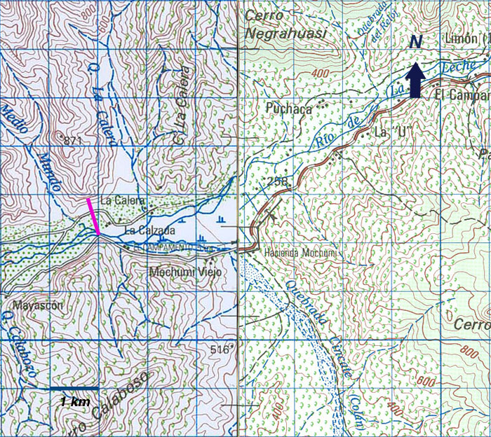
The main feature of the project is a rock-fill dam spanning a natural valley constriction at La Calzada,
between Quebrada La Calera and Quebrada Medio Mundo, near the hamlet of Mochumi Viejo.
The location of the dam axis is shown in Fig. 4.
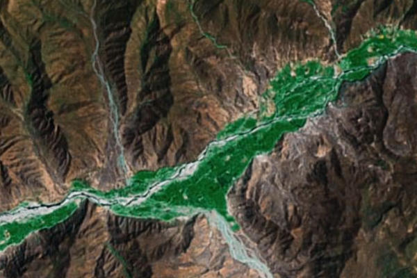
A satellite image of the reservoir site is shown in Fig. 5.
The proposed maximum
height of the dam is 57.8 m, to store a volume of
137,634,000 cubic meters (137.634 hm3).
The dam is designed to attenuate major floods, caused by El Niño events.
 |
|
Fig. 4 Location of proposed dam at |
 |
|
Fig. 5 Satellite image of proposed reservoir site at La Calzada (Source: Google Earth). |
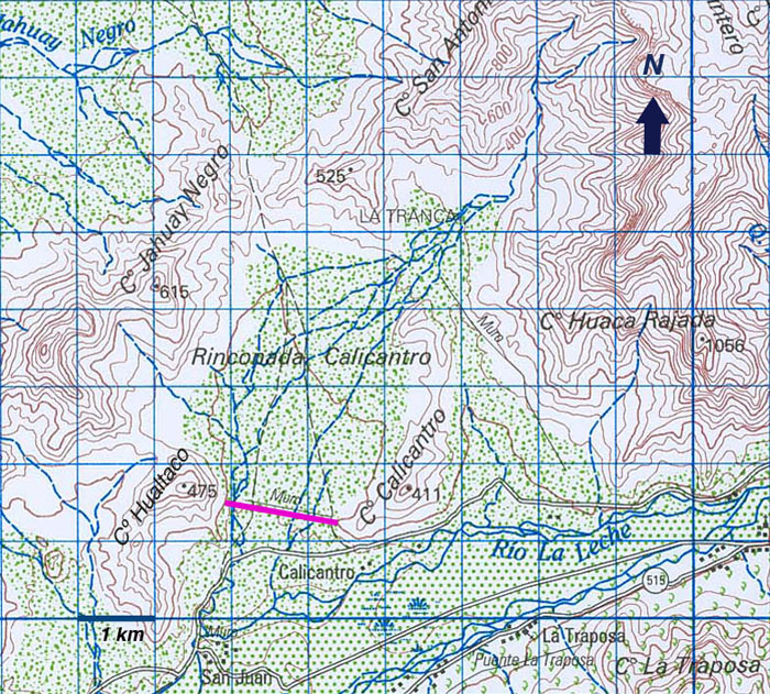
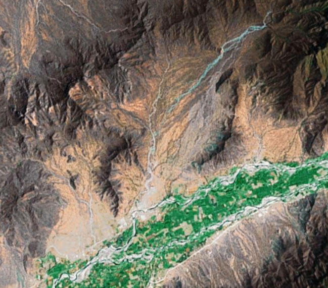
A second dam at neighboring Calicantro valley [Rinconada Calicantro] is proposed. Calicantro is an off-stream dam, located along Hualtacal Creek. The latter flows into the La Leche river near San Juan, about 11 km downstream (west) of La Calzada. The project includes a rock-fill dam between Cerro Hualtaco to the west and Cerro Calicantro to the east, with the approximate dam axis shown in Fig. 6, roughly corresponding with that of the ancient local feature labeled "Muro." A satellite image of the reservoir site is shown in Figure 7.
 |
|
Fig. 6 Location map of proposed dam at |
 |
|
Fig. 7 Satellite image of proposed reservoir site at Calicantro (Source: Google Earth). |
The proposed maximum height of the Calicantro dam is 27 m, to store a volume of 40,600,000 cubic meters (40.6 hm3). The project will require an intake structure and conveyance channel, the latter of approximate 11 km of length, to transport waters from La Calzada to Calicantro for seasonal and long-term storage.
For flood control purposes only, the dam at La Calzada will suffice. However, to extend the design life of the structure, the off-stream storage site at Calicantro is highly desirable. The design setting is similar to that of Tinajones dam, which is located on the neighboring Chancay river valley to the south. From the sedimentation standpoint alone, Tinajones, an off-stream storage project, is faring much better than comparable in-stream storage projects in neighboring basins. It is noted that Poechos, on the Chira river to the north, and Gallito Ciego, on the Jequetepeque river to the south, have undergone extensive sedimentation since they began operations 30 to 40 years ago.
In summary, the following hydraulic structures/features are considered:
- Rock-fill dam and reservoir at La Calzada.
- Principal and emergency spillways at La Calzada dam.
- Intake works at La Calzada dam.
- Conveyance channel from La Calzada reservoir to Calicantro reservoir.
- Rock-fill dam and reservoir at Calicantro.
- Principal and emergency spillways at Calicantro dam.