 |
|
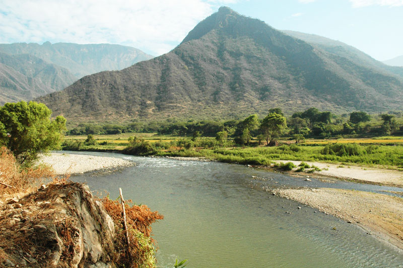
Fig. 1 Proposed damsite at |
LAMBAYEQUE, PERU
TASK 5: ENVIRONMENTAL IMPACT ASSESSMENT
PART 7: SECTIONS 10-12, APPENDICES, REFERENCES
July 24, 2009
Dr. Victor M. Ponce
Environmental Consultant
10. MITIGATION STRATEGIES
Mitigation strategies and/or measures are planned and implemented with the objective to reduce, minimize, and/or neutralize the negative
impacts that have been identified in the EIA. In some cases, mitigation measures will be effective in
reducing the impact; in other cases, it may be difficult to reduce the magnitude of the impact. A few net losses
are deemed an acceptable compromise for the social and socioeconomic benefits to accrue from the project.
Table 41 describes a set of mitigation strategies for the EES parameters tagged with major red flags in Table 40.
| Table 41. Mitigation strategies for EES parameters with major red flags. |
| (1) | (2) | (3) | (4) |
| No. | EES parameter | Description | Mitigation strategies |
| 1 | Terrestrial browsers and grazers | Affected fauna | The reduction in the number of browsers and grazers due to reservoir inundation cannot be readily mitigated. One possibility is to designate alternate areas for grazing, to replace the areas lost to inundation. This is particularly significant in the case of Calicantro. |
| 3 | Terrestrial natural vegetation | Affected flora | The reduction in the number of specimens of natural vegetation cannot be readily mitigated. The loss of this natural resource is considered to be a trade-off for the socioeconomic benefits to accrue from the project. |
| 12 | Land use | Loss of economically useful land | The loss of agricultural lands at La Calzada and grazing lands at Calicantro must be appropriately compensated. This loss is considered to be a trade-off for the socioeconomic benefits to accrue from the project. |
| 17 | River characteristics | Loss of swiftness of the stream | The streams' natural characteristics will be lost once the reservoirs are in place. This will cause significant changes in the hydrobiology, both positive and negative. The loss of the swiftness characteristics of streamflow cannot be readily mitigated. It is considered to be a trade-off for the socioeconomic benefits to accrue from the project. |
| 19 | Basin hydrologic loss | Decrease in runoff | The project will cause a major conversion of runoff to evapotranspiration. This will cause increased salinity in the soil, imposing the need for additional drainage. This effect can be mitigated by reserving a certain portion of the natural runoff to carry the salts to the sea or, in this case, to appropriate sinks such as the La Niña lake. |
| 28 | Stream flow variation | Reduction in flood magnitude and frequency | The project operation will attenuate and reduce a significant number of floods. The effect will be both positive and negative; on the one hand, flood damages will be reduced; on the other hand, basin flushing will be compromised. This effect can be mitigated by a program of periodic artificial floods to reset the basin, partially emulating the work of Nature. |
| 29 | Temperature | Increase in waterbody temperature | Water will be retained in the reservoirs, and this water will gradually increase in temperature in the tropical local climate. This will change the hydrobiology of the waterbody. This effect cannot be readily mitigated. |
| 30 | TDS | Increase in concentration of total dissolved solids | The concentration of total dissolved solids will increase as water naturally destined to runoff is converted to evapotranspiration, leaving the salts behind. This effect can be mitigated with a program of agricultural drainage. A certain portion of the runoff must be reserved to carry the waste solids to the ocean or to an appropriate sink. |
| Table 41. (Continued). | ||||||
| (1) | (2) | (3) | (4) |
| No. | EES parameter | Description | Mitigation strategies |
| 41 | Soil erosion | Degradation downstream of dam | The retention of sediments in the dams, particularly at La Calzada, will produce "hungry water," which will have the tendency to pick up sediments as it flows downstream. There is a need for judicious sediment management to offset the negative effects of aggradation (above the dam) and degradation (below the dam). |
| 42 | Noise | Increased ambient noise during construction | Some noise will occur during construction. It is very difficult to mitigate this effect. The noise will abate as the project is completed. |
| 45 | Width and alignment | Loss of view of the river | The width and alignment of the streams will be markedly affected by the project. There is no way to mitigate this impact. The loss of this natural aesthetic resource is considered to be a tradeoff for the socioeconomic benefits to accrue from the project. |
| 55 | Diversity of vegetation types | Loss of species diversity | The loss of vegetation diversity due to reservoir placement cannot be mitigated. The loss of this natural resource is considered to be a tradeoff for the socioeconomic benefits to accrue from the project. |
| 56 | Variety within vegetation types | Loss of biodiversity | The loss of variety within vegetation types due to reservoir placement cannot be mitigated. The loss of this natural resource is considered to be a tradeoff for the socioeconomic benefits to accrue from the project. |
| 57 | Manmade objects | Loss of natural scenic view | The reduction in aesthetics due to manmade objects cannot be readily mitigated. One possibility is to design them so that they are less obtrusive to the eye. To the extent possible, landscaping should be used as a way of providing a pleasing view of the facility and its surroundings. |
| 62 | Geological | Loss of fossil resources | The dams/reservoirs will flood land that is rich in paleontological resources. Efforts should be made to recover as much as these fossils as possible prior to the first flooding of the reservoirs. |
| 77 | Housing | Loss of housing | Local housing will be significantly affected by the project due to inundation. Compensation and relocation of the affected parties to suitable areas is a fundamental necessity of project development. |
10.1 Endangered species
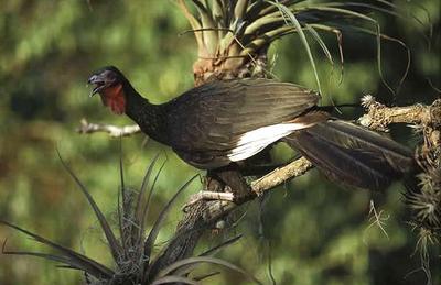
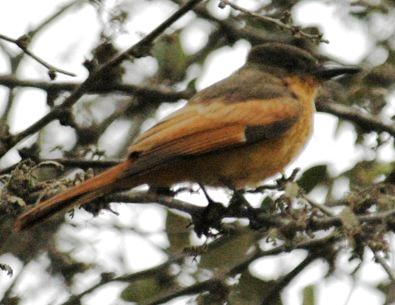
The conservation status of all faunal and floral species identified in this study is listed in Tables 6 and 7, respectively (Section 5.6). One bird species was identified as critically endangered (CE): the white-winged guan (Penelope albipenis); Fig. 54 (a). The habitat of this species is the relic montane ecosystem, which is not directly affected by the project. Two bird species were identified as endangered (EN): (1) the Peruvian plantcutter (Phytotoma raimondii), and (2) the rufous flycatcher (Myiarchus semirufus); Fig. 54 (b) and (c), respectively. The habitat of these species is the floodplain ecosystem, which is not directly affected by the project.
One tree species was identified as endangered (EN): (1)
the Andean walnut (Juglans neotropica).
The habitat of the Andean walnut is the relic montane ecosystem, which is not directly affected by the project.
| |||
|
|

|
Fig. 54 (a) White-winged guan (Penelope albipennis),
(b) Peruvian plantcutter (Phytotoma raimondii), and (c) rufous flycatcher (Myiarchus semirufus) (Source: Google and Wikipedia). |
10.2 Backwater effects
The channel slope at La Calzada is So = 0.0099 (Ponce, 2008a). With the dam height of 57.8 m, it is estimated that
the M1 backwater profile will extend
at least 5,838 m upstream of the dam (Chow, 1959). This distance reaches up to Puchaca, comprising Mochumi Viejo and La "U".
Detailed water-surface profile calculations are recommended to further refine this estimate. A hydraulic model such as
HEC-RAS may be used for this purpose (U.S. Army Corps of Engineers, 2008).
11. ENVIRONMENTAL MITIGATION PLAN
The environmental mitigation plan is the crux of the environmental impact assessment.
It focuses in mitigating the major negative impacts identified in the Leopold matrix and Batelle EES methods.
Accordingly, a mitigation plan has been developed for the following impacts:
The plan consists of:
- Rationale
- Methodology
- Schedule
- Monitoring
- Training
- Human resources, and
- Economic resources.
| Table 42 (A). Mitigation plan for impact of changes in water flow due to dam operation. |
| (1) | (2) | (3) | (4) |
| Action | No. | Phase | Mitigation plan |
A1. Ecological discharge |
1 | Rationale | A minimum ecological discharge must be maintained downstream of dam impoundments to assure the preservation of natural hydrobiological processes (Fig. 55). |
| 2 | Methodology | The ecological discharge should be developed based on local experience. In no case should it be less than 10% of the mean annual discharge. | |
| 3 | Schedule | The minimum ecological discharge should be maintained at all times, throughout the design life of the dam. The latter is estimated at 100 years. | |
| 4 | Monitoring | The regulated flow from the dam to the original stream should be monitored periodically to ensure compliance with the requirement of an ecological discharge. The recommended monitoring interval is once (1) per month. | |
| 5 | Training | One (1) civil/hydrologic engineer is required to assess the proper value of ecological discharge applicable to the La Leche river at La Calzada. | |
| 6 | Human resources | One (1) civil/hydrologic engineer, with field support personnel and logistical support. | |
| 7 | Economic resources | Low (less than U.S. $10,000); per year. |
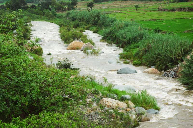 |
| Fig. 55 La Leche river upstream of La Calzada [photo 080211]. |
| Table 42 (A). Continued. |
| (1) | (2) | (3) | (4) |
| Action | No. | Phase | Mitigation plan |
A2. Recharge of groundwater downstream of dam |
1 | Rationale | The aquifer downstream of La Calzada should be monitored to detect increased rates of replenishment, which could be attributed to an increased rate of infiltration at the damsite. |
| 2 | Methodology | Groundwater baseline data, prior to reservoir operation, should be collected. A minimum of five (5) observation wells should be placed in strategic locations along the La Leche river, from La Calzada to Bosque de Pomac. Unusual increases in water table levels, after start of dam operation, should be documented. Measures should be taken, if necessary, to return the water table to baseline levels through appropriate pumping. | |
| 3 | Schedule | Water table should be measured at regular intervals, not to exceed three (3) months. Seasonal variations should be taken into account in establishing the appropriate measurement schedule. | |
| 4 | Monitoring | Monitoring should be performed at regular intervals, not to exceed three (3) months. | |
| 5 | Training | One (1) hydrogeologist is required to assess and monitor the changes in water table which may be attributed to the reservoir presence. | |
| 6 | Human resources | One hydrogeologist, with support personnel and logistical support. | |
| 7 | Economic resources | Medium (between U.S. $10,000 and U.S. $50,000); per year. |
| (1) | (2) | (3) | (4) |
| Action | No. | Phase | Mitigation plan |
A3. Loss of basin flushing |
1 | Rationale | There is a need to flush the basin at recurrent intervals to simulate Nature's use of floods as resetting or flushing agents. |
| 2 | Methodology | Artificial floods may be scheduled from time to time to flush the basin of accumulated sediments and other debris. | |
| 3 | Schedule | The schedule of artificial floods must be in accordance with the historic record of actual floods, which were not controlled by the dam and reservoir. In the absence of an actual flood, an artificial flood must be considered at least every five years, but not longer than every ten (10) years. | |
| 4 | Monitoring | Monitoring to assess the need for basin flushing should be performed at regular intervals, not to exceed five (5) years. | |
| 5 | Training | The training of one (1) civil/hydrologic engineer and one (1) river ecologist is required to assess the need for basin flushing. | |
| 6 | Human resources | One (1) civil/hydrologic engineer and one (1) river ecologist, with support personnel and logistical support. | |
| 7 | Economic resources | Low (less than U.S. $10,000); per year. |
| (1) | (2) | (3) | (4) |
| Action | No. | Phase | Mitigation plan |
A4. Risk of dam overtopping |
1 | Rationale | The reservoirs, particularly La Calzada, must be operated to all but eliminate the risk of dam failure due to overtopping. This requires thoughful reservoir operation rules. |
| 2 | Methodology | Operational rules must be developed to ensure that the emergency spillway is always able to pass the Probable Maximum Flood (PMF). For this purpose, the retarding-pool storage may be kept empty and ready for the PMF during the rainy season (Fig. 56). | |
| 3 | Schedule | Operational rules must be in place at all times to ensure that the emergency spillway is able to pass the PMF. | |
| 4 | Monitoring | Eliminating the risk of dam overtopping must have the highest priority. For this purpose, the reservoir should be monitored on a daily basis, particularly during the rainy season, and whenever strong El Niño events are expected. During El Niño events, the objective of daily monitoring should be to ensure that La Calzada always has its retarding-pool storage empty and ready to store a large flood. Local experience may dictate that even active storage be reserved for very strong El Niño events. Conjunctive use of La Calzada and Calicantro may enable the use of La Calzada only for flood control, reserving most active storage for flood attenuation. | |
| 5 | Training | The training of one (1) civil/hydrologic engineer is required to develop operating policy, and to assess and monitor dam/reservoir operation to minimize the possibility of dam overtopping. | |
| 6 | Human resources | One civil/hydrologic engineer, with field support personnel and logistical support. | |
| 7 | Economic resources | Medium (between U.S. $10,000 and U.S. $50,000); per year. |
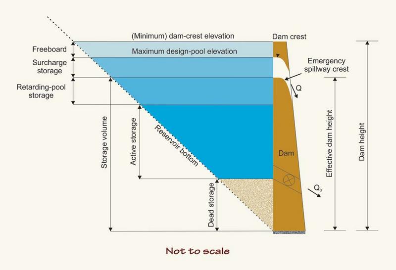 |
| Fig. 56 Storage volumes in reservoirs. |
| Table 42 (B). Mitigation plan for impact of changes in sediment flow due to dam operation. |
| (1) | (2) | (3) | (4) |
| Action | No. | Phase | Mitigation plan |
B1. Degradation below dam |
1 | Rationale | The water released from the dams will be relatively sediment-free, "hungry water." Thus, it will have the tendency to cause degradation downstream. |
| 2 | Methodology | The phenomenon of degradation below dams has been extensively documented by Lane (1955), Ponce (2008b), and others (Fig. 57). The amount of degradation can be estimated based on principles of hydraulic engineering. Conjunctive management of La Calzada and Calicantro reservoirs may help mitigate the effect of "hungry water," since a large portion of the water released from La Calzada may go into Calicantro, bypassing the La Leche river. | |
| 3 | Schedule | The degradation below dams typically occurs in the first ten (10) years of reservoir operation. Bed armoring may arrest degradation well before the new equilibrium channel slope has been established. | |
| 4 | Monitoring | Monitoring of channel bed degradation is recommended for at least the first five (5) years of reservoir operation. Measurements of bed profiles and associated cross sections immediately downstream of the dam should be performed every three (3) months. | |
| 5 | Training | The training of one (1) civil/hydraulic engineer is required to assess and monitor changes in bed profiles and associated cross sections resulting from channel degradation below the dam (La Calzada). | |
| 6 | Human resources | One (1) civil/hydraulic engineer, with field support personnel and logistical support. | |
| 7 | Economic resources | Medium (between U.S. $10,000 and U.S. $50,000); per year. |
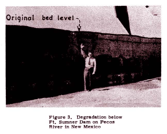 |
| Fig. 57 Degradation below Ft. Sumner Dam (Lane, 1955). |
| Table 42 (B). Continued. |
| (1) | (2) | (3) | (4) |
| Action | No. | Phase | Mitigation plan |
B2. Sediment accumulation in the reservoir |
1 | Rationale | Sediment accumulates in the reservoir due to water storage (Fig. 58). The rate of deposition is a function of the hydraulic and sedimentological properties of the river reach. Calculations of design life, or useful life, should take into account the gradual filling of the reservoir with sediment. |
| 2 | Methodology | Rate of reservoir filling of the reservoir should be estimated by appropriate methodologies. At a minimum, the Brune formula should be used to estimate design life (Ponce, 1989). | |
| 3 | Schedule | The rate of filling of the reservoir should be monitored every two (2) years. Bathymetric surveys are necessary to evaluate rate of filling. | |
| 4 | Monitoring | Monitoring of the rate of filling of the reservoir with sediment is required to follow up on the design and implement corrective measures, if necessary. Equipment for bathymetric surveys is required. | |
| 5 | Training | The training of one (1) civil/hydraulic engineer is required to assess and monitor rates of sediment deposition in the reservoirs (La Calzada and Calicantro). | |
| 6 | Human resources | One (1) civil/hydraulic engineer, with field support personnel and logistical support. | |
| 7 | Economic resources | Medium (between U.S. $10,000 and U.S. $50,000); per year. |
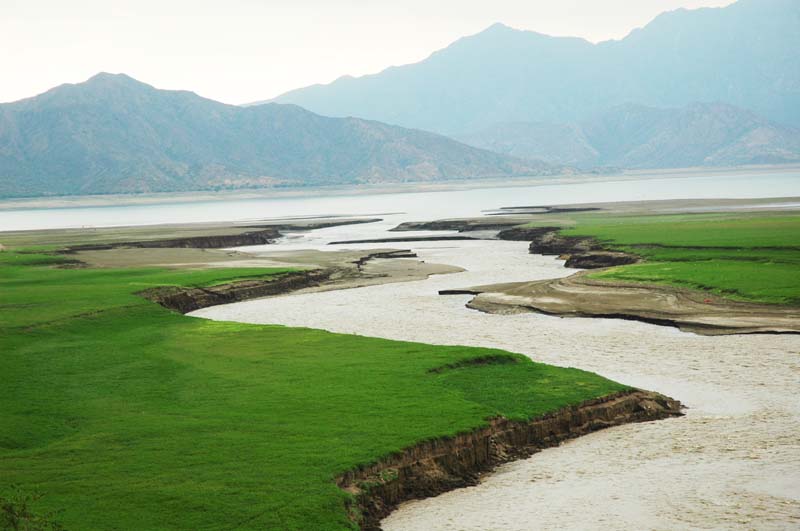 |
| Fig. 58 Sediment accumulation near tail of Tinajones reservoir, Lambayeque [photo 080211]. |
| Table 42 (C). Mitigation plan for impact of changes in nutrient flows flow due to dam operation. |
| (1) | (2) | (3) | (4) |
| Action | No. | Phase | Mitigation plan |
C. Nutrient deficiency in flood plain |
1 | Rationale | Continued reservoir operation will retain sediments and cause a long-term nutrient deficiency in the downstream flood plain. |
| 2 | Methodology | Nutrient deficiency can be mitigated by the proper choice of fertilizers, in addition to those commonly used. | |
| 3 | Schedule | A judicious use of fertilizers will be necessary to optimize the agricultural production and mitigate nutrient deficiency. | |
| 4 | Monitoring | Not applicable. | |
| 5 | Training | Not applicable. | |
| 6 | Human resources | Not applicable. | |
| 7 | Economic resources | Not applicable. |
| Table 42 (D). Mitigation plan for impact of dam and reservoir construction on local fauna. |
| (1) | (2) | (3) | (4) |
| Action | No. | Phase | Mitigation plan |
D. Impact on local fauna |
1 | Rationale | One (1) faunal species has been identified as critically endangered (CE): the white-winged guan (Penelope albipennis). Two (2) faunal species have been identified as endangered (EN): the Peruvian plantcutter (Phytotoma raimondii) and the rufous flycatcher (Myiarchus semirufus ) (Table 6, Section 5.6). |
| 2 | Methodology | The habitat of the white-winged guan is the relic montane forest ecosystem (upstream of the dams). The habitat of the Peruvian plantcutter and the rufous flycatcher is the floodplain ecosystem (downstream). No endangered faunal species are known to exist in the area to be flooded by La Calzada and Calicantro dams. | |
| 3 | Schedule | No action required. | |
| 4 | Monitoring | Not applicable. | |
| 5 | Training | Not applicable. | |
| 6 | Human resources | Not applicable. | |
| 7 | Economic resources | Not applicable. |
| Table 42 (E). Mitigation plan for impact of dam and reservoir construction on local flora. |
| (1) | (2) | (3) | (4) |
| Action | No. | Phase | Mitigation plan |
E. Impact on local flora |
1 | Rationale | One (1) tree species has been identified as endangered (EN): the Andean walnut (Juglans neotropica) (Table 7, Section 5.6). |
| 2 | Methodology | The habitat on the Andean walnut is the relic montane forest ecosystem, outside of the direct influence of the dams. | |
| 3 | Schedule | No action required. | |
| 4 | Monitoring | Not applicable. | |
| 5 | Training | Not applicable. | |
| 6 | Human resources | Not applicable. | |
| 7 | Economic resources | Not applicable. |
| Table 42 (F). Mitigation plan for loss of agricultural lands due to reservoir flooding. |
| (1) | (2) | (3) | (4) |
| Action | No. | Phase | Mitigation plan |
F. Loss of agricultural lands |
1 | Rationale | The flooding of La Calzada reservoir will result in the loss of valuable agricultural land. This encompasses the agricultural areas in the vicinity of Mochumi Viejo and La "U", and may reach Puchaca and beyond, depending on backwater conditions. |
| 2 | Methodology | The area to be inundated should be precisely determined by surveying and backwater calculations (HEC-RAS) (U.S. Army Corps of Engineers, 2008). Land values should be appraised and proper value or other compensation arranged to local landowners. | |
| 3 | Schedule | The survey should be carried out prior to dam construction. | |
| 4 | Monitoring | Not applicable. | |
| 5 | Training | One (1) surveyor is required to perform appropriate topographic surveys; one (1) hydraulic engineer to perform backwater calculations; one (1) rural economist to determine the value of the affected lands. | |
| 6 | Human resources | One (1) surveyor, one (1) hydraulic engineer, and one (1) rural economist, with field support personnel and logistical support. | |
| 7 | Economic resources | High (more than U.S. $50,000); nonrecurrent cost. |
| Table 42 (G). Mitigation plan for loss of grazing lands due to reservoir flooding. |
| (1) | (2) | (3) | (4) |
| Action | No. | Phase | Mitigation plan |
G. Loss of grazing lands |
1 | Rationale | The flooding of Calicantro reservoir will result in the loss of valuable grazing land. This encompasses the "La Viña" ranch, property of Mr. Jesús Montenegro Arrascue. Mr. Montenegro raises fighting bulls on his property. |
| 2 | Methodology | The area to be inundated should be precisely determined by surveying and backwater calculations (HEC-RAS) (U.S. Army Corps of Engineers, 2002). Land values should be appraised and proper value or other compensation arranged to the local landowner. | |
| 3 | Schedule | The survey should be carried out prior to dam construction. | |
| 4 | Monitoring | Not applicable. | |
| 5 | Training | One (1) surveyor is required to perform appropriate topographic surveys; one (1) hydraulic engineer to perform backwater calculations; one (1) rural economist to determine the value of the land. | |
| 6 | Human resources | One (1) surveyor, one (1) hydraulic engineer, and one (1) rural economist, with field support personnel and logistical support. | |
| 7 | Economic resources | High (more than U.S. $50,000); nonrecurrent cost. |
| Table 42 (H). Mitigation plan for loss of housing due to reservoir flooding. |
| (1) | (2) | (3) | (4) |
| Action | No. | Phase | Mitigation plan |
H. Loss of housing |
1 | Rationale | The flooding of La Calzada reservoir will result in the loss of valuable semirural housing comprised within the area to be inundated by the reservoir. This encompasses the populated areas of Mochumi Viejo, La "U", Puchaca, and vicinity. |
| 2 | Methodology | Housing values should be appraised and proper cost or compensation arranged to the local owners. Several dam height alternatives may be considered if the social costs of inundation are deemed to be excessive. | |
| 3 | Schedule | The survey should be carried out prior to dam construction. | |
| 4 | Monitoring | Not applicable. | |
| 5 | Training | One (1) economist or appraiser is required to determine the value of the properties. | |
| 6 | Human resources | One (1) economist or appraiser, with field support personnel and logistical support. | |
| 7 | Economic resources | High (more than U.S. $50,000); nonrecurrent cost. |
| Table 42 (I). Mitigation plan for the increase in salinity of soil and water. |
| (1) | (2) | (3) | (4) |
| Action | No. | Phase | Mitigation plan |
I. Increase in salinity of soil and water |
1 | Rationale | The conversion or runoff to evapotranspiration results in an increase in the salinity of soils and water, as shown by the extreme example of Tulare Lake Drainage District, in California (Fig. 59). The sources of these salts have been explained by Ponce (2009a), among others. |
| 2 | Methodology | A fraction of the runoff should be reserved for carrying the solids to the ocean or an appropriate sink (in this case, the La Niña Lake). The quantity of drainage waters should be an appropriate fraction of the original runoff. A waste runoff of 20% has been recently recommended by Ponce (2009b). | |
| 3 | Schedule | Baseline salt concentrations should be determined in the lands to be irrigated. The irrigated lands should be drained to eliminate and properly dispose of the salts. Drainage development should parallel irrigation development. | |
| 4 | Monitoring | The irrigated lands should be tested periodically to ensure that there is a measure of salt balance, i.e., no appreciable salt accumulation in the soil profile over a medium-term horizon of 10 years. Monitoring for salt balance should be performed at yearly intervals. | |
| 5 | Training | One (1) agricultural engineer to perform salt balance calculations. One (1) chemical engineer to perform soil and water salt concentration determinations. | |
| 6 | Human resources | One (1) agricultural engineer and one (1) chemical engineer or chemist, with field support personnel and logistical support. | |
| 7 | Economic resources | High (more than U.S. $50,000); per year. |
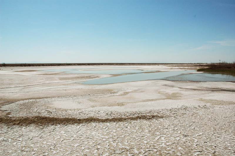 |
| Fig. 59 Evaporation basin at Tulare Lake Drainage District, California [photo 090417]. |
| Table 42 (J). Mitigation plan for loss of fossil resources. |
| (1) | (2) | (3) | (4) |
| Action | No. | Phase | Mitigation plan |
J. Loss of fossil resources |
1 | Rationale | The lands to be flooded by La Calzada and Calicantro reservoirs are rich in paleontological resources (see Section 4.2). |
| 2 | Methodology | A field survey and exploration should be conducted to determine the extent to which fossils can be found on the surface area to be flooded. Fossils found during the survey should be collected and delivered to the appropriate museums or institutions for safekeeping. | 3 | Schedule | The paleontological survey should be carried out prior to the first filling of the reservoirs. |
| 4 | Monitoring | Not applicable. | |
| 5 | Training | One (1) paleontologist to carry out field surveys and retrieval of fossil specimens. | |
| 6 | Human resources | One (1) paleontologist with field support personnel and logistical support. | |
| 7 | Economic resources | Low (less than U.S. $10,000); nonrecurrent cost. |
| Table 42 (K). Mitigation plan for loss of natural scenic view. |
| (1) | (2) | (3) | (4) |
| Action | No. | Phase | Mitigation plan |
K. Loss of natural scenic view |
1 | Rationale | Once in place, the dams will create reservoirs and result in the loss of the view of the river. |
| 2 | Methodology | The scenic beauty provided by the reservoir may serve to offset the loss of the scenic beauty of the stream. Architectural features such as landscaping may also help in offsetting the loss of natural scenic beauty. | |
| 3 | Schedule | Development plans should provide for various landscaping features to minimize the obtrusiveness of the hydraulic structures. | |
| 4 | Monitoring | Not applicable. | |
| 5 | Training | One (1) landscape architect to develop and implement plans for scenic enhancements to the project. | |
| 6 | Human resources | One (1) landscape architect with field support personnel and logistical support. | |
| 7 | Economic resources | Medium (between U.S. $10,000 and U.S. $50,000); nonrecurrent cost. |
| Table 42 (L). Mitigation plan for increase in noise during construction. |
| (1) | (2) | (3) | (4) |
| Action | No. | Phase | Mitigation plan |
L. Increase in noise during construction |
1 | Rationale | Construction operations (dam and spillway) are likely to result in increased noise levels. |
| 2 | Methodology | A noise policy in agreement with the Regulation Law of National Standards for Environmental Quality for Noise (Peru) (2003) should be developed. Efforts should be made during construction to ensure that noise levels are kept under control. Extremely noisy operations should be minimized and reserved for daylight hours. | |
| 3 | Schedule | Increased noise levels are expected only during the construction phase (first 5 years). | |
| 4 | Monitoring | Monitoring to manage and control noise levels should proceed during construction phase. | |
| 5 | Training | One (1) mechanical engineer to develop and monitor noise levels during construction. | |
| 6 | Human resources | One (1) mechanical engineer with field support personnel and logistical support. | |
| 7 | Economic resources | Low (less than U.S. $10,000); per year, for up to five years. |
12. SUMMARY
An environmental impact assessment (EIA) study of the La Leche river flood control project is described in this report. The project aims to enhance flood control and water conservation in the watershed of the La Leche river, which has suffered major floods caused by the El Niño phenomenon. The proposed actions are the construction of two rock-fill dams, one to retain floodwaters and the other to store water for irrigation and domestic water supply. The flood-control dam spans a natural valley constriction at La Calzada. The seasonal and multi-annual storage dam spans the valley of neighboring Rinconada Calicantro to the west of La Calzada.
The environmental impact assessment is performed using the following two well-established methodologies:
- the Leopold matrix, and
- the Battelle Environmental Evaluation System.
The Leopold matrix is described in Section 9.1. The study has identified the following major impacts:
Impact of dams on soils: Dams will retain sands and silts. This will cause degradation of the downstream reach of the La Leche river, as clear water is released from the dam into the channel.
Impact of dams on soil moisture: Dams will retain water. This retention will change the natural distribution of precipitation. More water will go into soil moisture, and therefore, into evapotranspiration.
Impact of dams on nutrients: The reservoirs will hold sands and silts, and therefore, retain the nutrients that are embedded in the sediments. These nutrients will be sequestered and unavailable for use by plants.
Impact of dams on crops: The crops inundated by the reservoir(s) will be lost. The inundated areas can be replaced by irrigated areas downstream, but the physical, chemical, and biological settings is not likely to remain the same.
Impact of dams on agriculture: Substantial portions of the land, which currently are dedicated to agriculture, will be rendered inoperable by the flooding of the reservoir.
Impact of dam failure on structures: Dam failure will cause catastrophic damage to structures. Therefore, the dam/reservoir should be designed using maximum safety criteria (Probable Maximum Flood).
The Battelle Environmental Evaluation System is described in Section 9.2. The application of the methodology has produced a cumulative index of environmental impact EI = -26.3. The negative value indicates that the cumulative impact will be adverse. However, the small relative magnitude of EI indicates that the impact will be readily subject to mitigation.
The EES has identified the following major impacts (Table 41):
Affected fauna.
Affected flora.
Loss of economically useful land.
Loss of swiftness of the stream.
Decrease in runoff.
Reduction in flood magnitude and frequency.
Increase in waterbody temperature.
Increase in concentration of total dissolved solids.
Degradation downstream of dam.
Increased ambient noise during construction.
Loss of view of the river.
Loss of species diversity.
Loss of biodiversity.
Loss of natural scenic view.
Loss of fossil resources.
Loss of housing.
Mitigation measures are formulated for the major impacts identified by the Battelle methodology (Table 41). Detailed plans are developed to mitigate the major negative impacts that may be produced by the project (Table 42). The major negative impacts are grouped into similar categories and expressed as follows:
- Impact of changes in water flow due to dam operation.
- Impact of changes in sediment flow due to dam operation.
- Impact of changes in nutrient flows due to dam operation.
- Impact of dam and reservoir construction on local fauna.
- Impact of dam and reservoir construction on local flora.
- Loss of agricultural lands due to reservoir flooding.
- Loss of grazing lands due to reservoir flooding.
- Loss of housing due to reservoir flooding.
- Increase in salinity of soil and water.
- Loss of fossil resources.
- Loss of natural scenic view.
- Increase in noise during construction.
The most significant impacts are identified as follows:
- The changes in water and sediment flow (Tables 42 A and B, respectively),
- The loss of housing due to reservoir flooding (Table 42 H), and
- The increase in salinity of soil and water (Table 42 I).
Mitigation is an established strategy to minimize the negative impacts of flood control and water supply projects.
APPENDICES
I. The Leopold Matrix for Evaluating Environmental Impact.
II. The Battelle Environmental Evaluation System for Water Resource Planning.
III.
The Battelle Environmental Evaluation System value functions.
REFERENCES
Carpio, M. L. 1999. Consideraciones sobre los endorreismos de la costa norte del Perú en su relación con eventos de El Niño.
Papeles de Geografía, No. 30, 87-102.
Chow, V. T. 1959. Open-channel hydraulics. McGraw-Hill, New York.
Dee, N., J. Baker, N. Drobny, K. Duke, and D. Fahringer. 1972.
Environmental evaluation system for water resource planning (to Bureau of Reclamation, U.S. Department of Interior).
Battelle Columbus Laboratory, Columbus, Ohio, January, 188 pages.
Dee, N., J. Baker, N. Drobny, K. Duke, I. Whitman, and D. Fahringer. 1973.
An environmental evaluation system for water resource planning. Water Resources Research, Vol. 9, No. 3, June, 523-535.
Gobierno del Perú. 1969a. Ley General de Aguas. Decreto Ley No. 11752.
Gobierno del Perú. 1969b. Reglamento de los Títulos I, II y II de la Ley General de Aguas (Decreto Ley No. 11752), Decreto Supremo No. 261-69-AP.
Gobierno del Perú. 2001. Reglamento de Estándares Nacionales de Calidad Ambiental del Aire. Decreto Supremo No. 074-2001-PCM.
Gobierno del Perú. 2003. Reglamento de Estándares Nacionales de Calidad Ambiental para Ruido. Decreto Supremo No. 085-2003-PCM.
Lane, E. W. 1955. The importance of fluvial morphology in hydraulic engineering. Proceedings, American Society of Civil Engineers, Vol. 81, Paper 745, July.
Leopold, L. B., F. E. Clarke, B. B. Hanshaw, and J. E. Balsley. 1971. A procedure for evaluating environmental impact.
U.S. Geological Survey Circular 645, Washington, D.C.
McPhee, J. 1989. The Control of Nature. Farrar, Straus and Giroux.
Pardo, A., and V. Sanz. 1979. Estratigrafía del curso medio del Río La Leche, Departamento de Lambayeque.
Boletín de la Sociedad Geológica del Perú,
No. 60, Abril, 251-266.
Ponce, V. M. 1989. Engineering Hydrology: Principles and practices. Prentice Hall, Upper Saddle River, New Jersey.
Ponce, V. M., and A. V. Shetty. 2008. The facts about El Niño. (http://elnino.sdsu.edu) (090515).
Ponce, V. M., A. K. Lohani, and P. T Huston. 1997. Surface albedo and water resources: The hydroclimatological impact of human activities.
Journal of Hydrologic Engineering, ASCE, Vol. 2 No. 4, October.
Ponce, V. M. 2008a. La Leche River Flood Control Project: Third Project Report--Final (Hydrology), July 2, 2008. [090424].
Ponce, V. M. 2008b. The Lane relation revisited. (http://lane.sdsu.edu) (090722).
Ponce, V. M. 2009a. The salt predicament. (http://salt.sdsu.edu)
(090722).
Ponce, V. M. 2009b. Sustainable runoff for basin salt balance. (http://sustainablerunoff.sdsu.edu)
(090722).
U.S. Army Corps of Engineers. 2008. HEC-RAS: River Analysis System, Hydrologic Engineering Center, Davis, California, Version 4.0.
 |
| Fig. 60 Black-faced ibis [bandurria] (Theristicus melanopis), sometimes seen in the Prosopis forests of the La Leche river. |
| 210902 |